


October 20, 2017 - Most of us have had the bittersweet experience of driving past a house or property where our grandparents lived. Even though they may be gone and the property now owned by others, the place where they spent their lives still has an emotional resonance with most of us. However, as generations pass, knowledge of where our ancestors lived is usually lost. Jim Barrett demonstrated a software tool at the October Timpson Area Genealogical and Heritage Society that can help anyone who want to research the location of property formerly owned by their ancestors.
 DeedMapper, published by Direct Line Software, is “the premier software program for working with old land records, especially those that were surveyed using the metes and bounds survey system. Our site is for anyone who's interested in platting those old land patents, grants, and deeds, and placing them on a modern map” according to their website. As Mr. Barrett explained, most states were platted using the U.S. Bureau of Land Management Public Land Survey System (PLSS), which divides the state into square ranges, which are subdivided into townships, and then sections. The location property using the PLSS is fairly easy to plot since it is on a standard grid.
The metes and bounds system is much older and more difficult to work with since the boundaries of property are usually delineated by topographical features or landmarks, such as creeks, large rocks, roads, trees, and wooden stakes. Mr. Barrett pointed out that working with the metes and bounds system is difficult for obvious reasons. First, the property boundaries are usually of an irregular shape, and second, many of the landmarks referenced in the deed disappear over time. The metes and bounds system is found in East Coast states and...Texas.
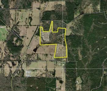
Mr. Barrett demonstrated the use of DeedMapper using first a cemetery, the land for which was donated by Mr. Barrett's grandfather in Erath, later Hood, County. Using the cemetery deed he was able to plot the cemetery's location and then overlay a modern topographical map, establishing its boundaries for demonstration purposes. He then plotted out several parcels of land which had been owned by Mrs. Barrett's father near Timpson. The boundaries of these plots were irregular, the westernmost being the Attoyac River. A modern topographical map overlay made the land's location much more recognizable.
Most of the TAGHS audience recognized the value of such a tool for serious genealogical research as well as simple curiosity and exploration and Mr. Barrett fielded a number of questions regarding the programs cost and use.
The Timpson Area Genealogical and Heritage Society meets on the third Wednesday of each month at 2pm in the Meeting Room of the Timpson Public Library, located on the corner of Austin and Bremond Streets in downtown Timpson. The public is invited