


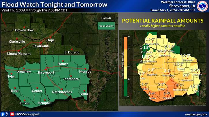
Excessive heavy rainfall is back in the forecast beginning tonight and continuing into tomorrow. Accumulations of 2 to 4 inches are expected. A Flood Watch will be in effect from 1 AM through 7 PM tomorrow.
May 1, 2024 - The National Weather Service, Shreveport, Louisiana issued a Flood Watch at 2:22pm, Wednesday, May 1, 2024 and the Flood Watch remains in effect from 1am Thursday through Thursday evening.
Flooding caused by excessive rainfall continues to be possible for portions of Louisiana, including the following parishes, Bienville, Bossier, Caddo, Caldwell, Claiborne, De Soto, Grant, Jackson, La Salle, Lincoln, Natchitoches, Ouachita, Red River, Sabine, Union, Webster and Winn; and Texas, including the following counties, Angelina, Cherokee, Gregg, Harrison, Nacogdoches, Panola, Rusk, Sabine, San Augustine, Shelby and Smith.
From 1am CDT Thursday through Thursday evening excessive runoff may result in flooding of rivers, creeks, streams, and other low-lying and flood-prone locations. Flooding may occur in poor drainage and urban areas.
A complex of showers and thunderstorms is expected to develop this evening over Central Texas, and quickly shift east across East Texas late tonight and into North Louisiana by and after daybreak Thursday. Locally heavy rainfall is possible with these storms, with widespread rainfall amounts of one to three inches expected, with isolated higher amounts possible. Grounds remain saturated in wake of heavy rainfall that fell Sunday night and Monday, with this additional rainfall quickly running off and possibly resulting in flash flooding.
http://www.weather.gov/safety/flood
You should monitor later forecasts and be alert for possible Flood Warnings. Those living in areas prone to flooding should be prepared to take action should flooding develop.