April 20, 2023 - The National Weather Service, Storm Prediction Center, Norman, OK, issued a Severe Thunderstorm Watch outline update for WS 153 at 1:50pm, Thursday, April 20, 2023.
The severe thunderstorm watch 153 is in effect until 9pm for the following locations in Texas: Anderson, Bell, Bosque, Bowie, Brazos, Burleson, Camp, Cass, Cherokee, Coryell, Delta, Ellis, Falls, Fannin, Franklin, Freestone, Gregg, Hamilton, Harrison, Henderson, Hill, Hopkins, Houston, Hunt, Kaufman, Lamar, Lampasas, Leon, Limestone, Madison, Marion, McLennan, Milam, Mills, Morris, Nacogdoches, Navarro, Panola, Rains, Red River, Robertson, Rockwall, Rusk, Shelby, Smith, Titus, Upshur, Van Zandt, and Wood.
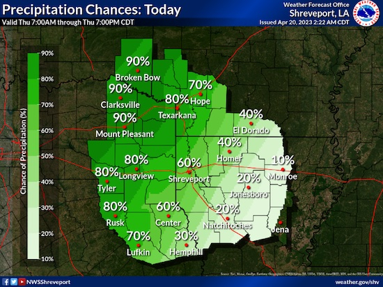
Hazardous Weather Outlook
National Weather Service, Shreveport, LA, issued a Hazardous Weather Outlook at 12:46pm, Thursday, April 20, 2023 for the following locations in Arkansas, Louisiana, Oklahoma, and Texas: Sevier, Howard, Little River, Hempstead, Nevada, Miller, Lafayette, Columbia, Union, Caddo, Bossier, Webster, Claiborne, Lincoln, De Soto, Red River, Bienville, Jackson, Ouachita, Sabine, Natchitoches, Winn, Grant, Caldwell, La Salle, McCurtain, Bowie, Franklin, Titus, Camp, Morris, Cass, Wood, Upshur, Marion, Smith, Gregg, Harrison, Cherokee, Rusk, Panola, Nacogdoches, Shelby, Angelina, and San Augustine.
This article is copied from Shelby County Today without permission.
This Hazardous Weather Outlook is for south central Arkansas, southwest Arkansas, north central Louisiana, northwest Louisiana, southeast Oklahoma, east Texas and northeast Texas.
This afternoon and tonight: Strong to severe thunderstorms will begin to develop this afternoon across much of the Four-State region and become more widespread this evening into the overnight hours. Some of these storms could produce large hail and damaging thunderstorm wind gusts. While conditions are not conducive for a widespread tornado outbreak, isolated tornadoes cannot be ruled out. In addition to the severe weather threat will be an excessive heavy rainfall threat this afternoon through overnight across much of the region. That excessive heavy rainfall threat will shift farther south and east into more of North Central and Northeast Louisiana the first half of Friday. Low-lying and poor drainage flood prone areas will be the most susceptible to flash flooding late today through tonight and into early Friday.
This article is copied from Shelby County Today without permission.
Friday through Wednesday: While showers and thunderstorms will be possible across portions of the Four-State Region next week, atmospheric instability does not appear significant enough or the development of strong to severe thunderstorms at this time.
Spotter Information Statement: Spotter activation will most likely be needed this afternoon into the evening and overnight hours for the threat of severe thunderstorms.