

The story headline links to a better view of the story and share features.


News

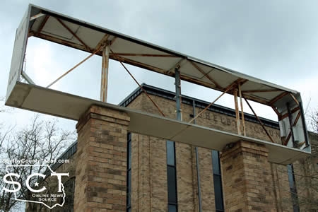
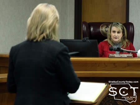
March 14, 2021 - As Shelby County continues its quest for reliable communications for emergency personnel, the commissioners are now faced with an even larger price tag than before of potentially $206,000.
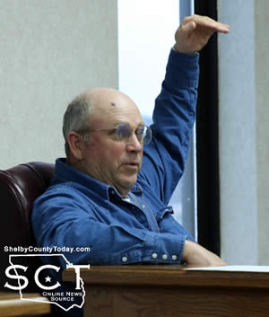
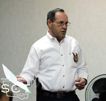
Sheriff Kevin Windham was accompanied by Tracy Rook, Texas Premier Communications, LLC, who presented a proposal for the Sheriff's Department radio system and the volunteer fire department radio system which is dispatched out of the Sheriff's Department.
The proposal for the system dispatching deputies in Shelby County is $117,304 and the separate estimate of cost for the volunteer fire department radios is $88,696. Sheriff Kevin Windham reminded the commissioners around $55,000 was invested in the communications system at the end of 2020 to replace the communications console as the system was not functioning at that time.
"We knew that would not fix the entire radio problem, at the current time we still have no radio service in Timpson. Once you get about just north of FM 1645, we have no radio communication," said Sheriff Windham. "You get into Tenaha, Joaquin, same issues."
Sheriff Windham mentioned a roadway called Hawthorne Road in the south end of the county where he was recently unable to utilize communications. He stated a solution to the problem has been being sought for quite some time and most recently Texas Premier Communications has been working to develop a solution.
"They have found a solution to the problem, so I have asked them to put together the information and let them speak to you because I'm not qualified to answer the questions that could be asked regarding the radios and how this is going to work," said Sheriff Windham.
Sheriff Windham remarked the cost is great; however, he reminded the court the system affects officer safety and those in the public they seek to protect. He stated how glad he is the commissioners also want the officers and members of the public to be safe.

According to Rook the proposed project includes three tower sites which will interact at the same time. They would be outfitted with three microwave antennas for a VHF system to extend the signal further and simulcast. No longer will the radio signal from officers have to travel all the way to the tower on State Highway 7 before reaching the Sheriff's Department.
"We've done some research and I could never find microwave paths between the water tower in Tenaha and the one in Shelbyville to Highway 7," said Rook. "I sent it off to the manufacturer in Israel that builds the microwaves and they found an issue with our software that was giving me the wrong calculations."
Rook said the manufacturer said there is a path, and he proposes installing the microwave antennas with the addition if it doesn't work Texas Premier Communications will take the antennas back and it won't cost the county. Installation and removal would still be an expense.
County Judge Allison Harbison asked about additional cost to use the towers and Rook said he didn't think there would be any. The City of Tenaha owns one water tower and the other tower in Shelbyville used to have equipment on it and he didn't expect there to be a cost.
"This will rebroadcast everything, it's going to give them a whole lot more coverage, a lot more portable coverage. Is this going to fix every spot in the county? No ma'am," said Rook.
Commissioner Stevie Smith asked about the possibility of using a tower in the Joaquin area.
In response to Judge Harbison, Rook explained the work done to the Sheriff's Department radio communications will not improve the fire department communications; however, it could be added on to and would be at a lesser cost. If the equipment for both were done at the same time, it also would reduce overall expense to the county.
"The time servers are what's expensive, and the microwaves. The time servers are about $10,000 each, so you've got three time servers that you can share," said Rook. "So you knock out close to $30,000 right there."
Roscoe McSwain, Commissioner Precinct 1, brought up the possibility of utilizing some of the COVID relief funds Ann Blackwell, County Treasurer, and Clint Porterfield, County Auditor, were able to get reimbursed to the county to go toward the radio work. Porterfield had originally recommended the commissioners set those funds aside to go toward possible Shelby County Jail work in the future.
Discussion continued on the radio system and the commissioners decided to table the item until the next meeting to consider each proposal.
A motion carried to table the discussion of the radio system for the Sheriff's Department until the next meeting.
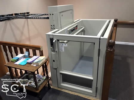
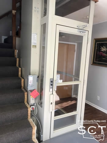
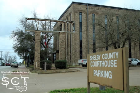
Judge Harbison presented the commissioners with needed repair to the foyer of the Courthouse Annex (District Attorney's office) to complete the elevator installation project.
"We need to build some barriers at the top of the elevator where they had to cut the railing. There needs to be some solid walls put there," said Judge Harbison.
She proposed putting a wall up even with the top of the elevator to provide an added safety measure for children and to prevent anyone falling over. Since the project is expected to be under $50,000 Judge Harbison sought bids from two separate contractors and received a bid for one.
The bid was for $17,447 to build finished walls/railing ap the stairwell and around the new elevator, floor covering on stairs, and floorcovering on the second floor at the top of the stairs/elevator.
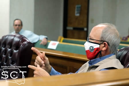
"I am a little bit queasy about jumping out and burning all of our building maintenance and digging into our contingency pretty hard," said Tom Bellmyer, Commissioner Precinct 4.
With there being so many large expenditures recently the county has had to face, Bellmyer initially wanted to wait until the year progressed further due to unknown possible liabilities in the future. Porterfield mentioned another contingency fund available to the county of compressor litigation which wasn't used last year and was budgeted for this year.
"We could amend the budget with the grey public necessity clause, because of the danger of the handrail and the elevator that's been installed," said Porterfield.
Bellmyer said he doesn't want the county to take the chance of someone getting injured and he is in favor of getting the repairs completed as safety is more important.
"We are out of money because it was unforeseen that we was going to pay $186,000 to settle a lawsuit (Morrow v. Tenaha), so if we need to fix this, we need to fix it," said McSwain. "It sounds like we've blown through a lot of money, we ain't blowed through nothin'. We blowed through our contingency, because we had to pay off that lawsuit."
During the discussion, Bellmyer indicated he wants to make the repairs and he made a motion to move forward with the repairs and a budget amendment per recommendation of Porterfield.
Judge Harbison clarified a budget amendment to courthouse repair of $18,000 to move forward with having the repair done due to the safety nature of the needed repair, and for TNT Construction to handle the repair.
Commissioner McSwain seconded the motion.
Judge Harbison presented the commissioners with a proposal to replace the courthouse sign which was damaged during Hurricane Laura in 2020. She stated a bid of $15,000 was received to repair the sign as-is, and that estimate has been submitted to FEMA for possible reimbursement.
"What I am proposing is that we do a digital sign out here. A digital sign that allows us to put messages up like 'Burn Ban in Effect,' 'Early Voting Starts This Day,' 'Courthouse Closed for 4th of July,' I mean things like that, 'Jury Duty Cancelled,'" said Judge Harbison.
The sign could then also flash a date, time and temperature and has a projected cost of almost $30,000. The main portion of that cost is $27,380 and includes the manufacture and installation of a 41"X99" double pack electronic message center. The viewing area is 3'x8' with 16mm RGB pixel pitch, EMC capable of up to six lines 28.8 characters at a 4" type. The electronic message center can also play clips up to 30 frames per second, imports Window Video AVI, animated text and graphics, 4G Wireless with a life-of-sign cellular data plan.
Additionally $2,260 of the total cost goes toward a 3'x8'.3" lighted double sided sign with customer approved artwork, and the electronic message center would be mounted beneath with a 1.5" reveal and 3' ground clearance and the structure to be mounted on two posts.
"Replacing it as-is is going to be $15,000, so really and truly for what you're getting it's not that much more," said Judge Harbison.
A motion carried to table the item and wait for an additional quote to consider at the next meeting on March 17, 2021.
Joe Johnson addressed the court about his desire of Private Road Bussey Lane to be made into a county road.
"I live out there at Bobo and I stay on 4657, a county road, I stay off I'm on the corner of Bussey Lane and 4657," said Johnson. "It's so rough going up through there and Bussey Lane, it needs repairing it needs some road work and they say they can't come down there because it's a private road."
No action was taken so the commissioners and County Judge can further investigate who property owners are around Bussey Lane.
Judge Harbison opened sealed bids on road maintenance materials for Shelby County. A motion carried by the commissioners to accept all of the bids.
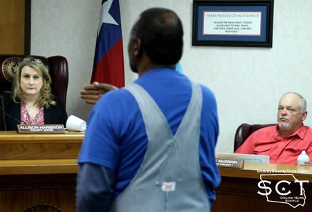
The commissioners considered the racial profiling report presented by the Shelby County Sheriff's Department. As they were reviewing the documents, Sheriff Windham elaborated on the report to explain for anyone unaware for what the report is needed.
"TECOLE (Texas Commission on Law Enforcement), they require us to file an annual report with the commissioners' court and bascially what it is, it documents all of our traffic stops, people that we contact and it tells you the reason they were stopped, if citations were issued, their ethnicity, it just records all of that and all of that is sent to the state. Just so they'll make sure we're not profiling," said Sheriff Windham.
A motion carried to record the report.
The meeting was adjourned.
Related Articles:
- Analog Radio System Shutdown Affects Local Fire Departments
- County Enters into Long-Term Lease Agreement for Radio Tower Use
- Commissioners Grill Ambulance Service on Procedures; Have Round-Table Discussion on Radios
- Commissioners Consider Potential $70,000 Emergency Expenditure
- Commissioners Upgrade Sheriff's Department Dispatch Equipment
Agenda items approved during the meeting include:
1. Approve the minutes of the February 10, 2021 Regular meeting, February 24, 2021, Special meeting of the Shelby County Commissioner’s Court.
2. Pay weekly expenses.
3. Officers Reports.
4. Repair the foyer of the Courthouse Annex which will complete the elevator installation project.
5. Open sealed bids on road maintenance materials for Shelby County.
6. Record Racial Profiling Report for the Shelby County Sheriff's Office.
7. Participation in the TAC CyberSecurity required annual training for 2021. This training is mandatory under state law, Texas Government Code 2054.5191, effective June 14, 2019, for all Elected County Officials and any local government employee who has access to a local government computer system or database.
8. Appoint Ann Blackwell as Course Administrator(s) for TAC CyberSecurity required annual training for 2021.
9. Adjourn.

Agenda items tabled during the meeting include:
1. Take action to replace the Courthouse sign that was damaged during Hurricane Laura.
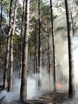
Angelina/Sabine RX Burn "Patroon RX Burn Block A & B" 1,986 acres
March 12, 2021 - Officials with the National Forests and Grasslands in Texas, Sabine National Forest, have advised a prescribed burn involving approximately 1,986 acres located, in the Patroon/Goober Hill and Dreka area. The winds are predicted from the South all day and tonight, and long range drift may affect some of the areas.
 March 12, 2021 - Greg Grant will be conducting controlled burns on his pine savanna projects in Arcadia March 13-21.
In addition to creating a scenic, open, park-like pine forest, regular prescribed fire reduces fuel loads decreasing the chance of catastrophic fires during the summer; controls undergrowth, diseases, and insects; and promotes wildlife habitat for deer, turkey, quail, pollinators, and pine savanna songbirds like brown headed nuthatches, pine warblers, Bachman’s sparrows, and red cockaded woodpeckers.
March 11, 2021 - The Texas DSHS Covid-19 Dashboard updated Thursday, March 11th reporting 8 new cases and 9 new recoveries over the past two days. The new estimated active case count is 87.
Of the new active cases, 1 was a new confirmed case and 7 were new probable cases.
March 11th (3:15pm) Numbers: (changes since March 9th)
Total Confirmed Cases - 881 (1 new case)
Total Probable Cases - 671 (7 new cases)
Total Fatalities - 59
Total Estimated Active Cases - 87
Total Estimated Recovered - 1,406 (9 new)

March 10, 2021 - Shelby County Sheriff Kevin Windham reports the arrest of Robert Bradly Lindsey, 58, of Center.
On March 9, 2021, a team of sergeants with the Office of the Texas Attorney General Criminal Investigations Division Child Exploitation Unit served search warrants on Lindsey as a result of a report initiated by the National Center for Missing and Exploited Children. The investigation revealed Lindsey to be in possession of child pornography.
Lindsey is a registered sex offender with the Shelby County Sheriff’s Office. During the course of the investigation, the Shelby County Sheriff’s Office was able to identify violations on Lindsey’s registration and charged him with three violations.
Lindsey was booked into the Shelby County Jail on two charges of Child Pornography (F-3) and three charges of Failure to Comply with Sex Offender Registration Requirements with a Previous Conviction (F-2).
Lindsey was arraigned by Justice of the Peace Precinct 1 Donna Hughes and he is being held in the Shelby County Jail on bonds totaling $800,000.
The SCSO does not take lightly the severity of crimes against children. Tips and information regarding sex offenders are encourage to be reported. Currently Shelby County has approximately 115 sex offenders residing in our area. Questions and concerns regarding offenders can be directed to Leah Chase – SCSO Sex Offender Registrar by calling our office at 936.598.5601.
The SCSO would like to extend a sincere thanks to the OAG for allowing us to be a part of this investigation. Their diligence to this case resulted in removing a child predator from the streets.
March 8, 2021 - The Shelby County Commissioners' Court voted to move funds from the Pretrial Intervention Program and Drug Court Program accounts for the District Attorney's office to make needed technological upgrades.
This decision was made during the March 3, 2021 meeting of the commissioners' court.
Roscoe McSwain, Commissioners Precinct 1, made a motion to "amend the pretrial diversion budget by $11,000 to be moved to satisfy in lieu of what we talked about doing with it, and $17,500 to be re-allocated in the drug court program."
The motion was seconded and carried.
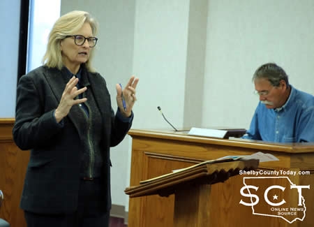
Karren Price, Shelby County District Attorney, spoke with the commissioners' court about the Pretrial Intervention Program funds and the Drug Court Program funds. She suggested they are in "kind of a grey" area.
"I have spoken to for the record Panola County, Gregg County, Angelina County, Collin County, Jefferson counties about their budgets and how they spend this money," said Price.
Price explained, Pretrial Intervention funds are collected by the Probation Department which is a state agency and subject to audit by the state, and she stated they are regularly audited by the state and the county auditor.
"My proposal is to dedicate 10% of an administrative clerk's time and efforts to Pretrial Diversion so that we are directly accountable on that, and we're not going to get in trouble in an audit situation because of it," said Price.
Price stated the county drug court is not officially a drug court, because it isn't registered with the state.
"So we're not officially a drug court. We operate as one does, but we're not registered," said Price, "Therefore, the only auditing is local. So all I can find, and it is even more grey than Pretrial Diversion expenditures."
Price said there are a number of Attorney General opinions on Pretrial Diversion and she says she has read every one of them.
"I've discussed every one of them with the Assistant DA and all of those places that I've told you about, and they have sent me their budgets," said Price. "They pretty much spend it like we would a general budget every year for an office."
The safest approach, according to Price for both funds is to make a substantial connection to probationers and expenditures that directly affect their rehabilitative process.
"Techshare, the software program, is in the process of building our program out for us, and our probation department will have a portal to communicate with us directly," said Price.
All of the files in the District Attorney's office are under an internal audit, according to Price, to discover if those involved in the cases are candidates for Pretrial Diversion, or Drug Court.
"Are we substantially using the funds? Yes we are, and that's how we're going to do it," said Price. "Every file will be evaluated for that funneling effect."
Price listed the needs of the District Attorney's office and the County Attorney's office and one of those items is fiber optic between their offices and the courthouse. She explained all of the computers and scanners in the District Attorney's office are failing constantly, and part of the reason for that is the server utilized by the District Attorney's office is 22 years old. Operating systems on the computers are so outdated they can't be updated any longer.
"It's not a question of we want it, it's a question of we can't get the work done," said Price.
The infrastructure has had no attention, according to Price, and the money is available to make the needed upgrades.
"The AG's opinions say you can pay staff salaries out of it, including assistant DAs, you can pay travel and training, you can refurbish the courthouse facilities," said Price. "Pretty much whatever you need as long as you can connect it to those programs."
The District Attorney wants to drug test those involved in the drug court program. She said the testing is no longer done, and that is mostly because of COVID-19. Once up and running she feels that would be important to be able to test those they are trying to keep off drugs.
Judge Harbison asked Price if a fee is still being collected of those involved in drug court and if the county can collect a fee if they aren't registered with the state.
"The statute doesn't require you to register and it allows for more than one county, you know two or three counties to go together, and kind of do their own policing of each other," said Price. "So it isn't necessary by statute that we be registered. The advantage to us for registration, I suppose is the access to those really big grants. The downside of being registered and having access to those grants is you have an audit every 90 days that is pretty debilitating I'm told."
Judge Harbison asked if the Pretrial Diversion Program and Drug Court each have a plan in place, as she didn't believe the court every received a plan for either program when they were established four to five years previous to Price taking office.
Price said she doesn't know of one; however, she didn't believe the District Attorney's office would have received federal grant funding without having a plan in place. She said she would do the research.
"As I understand the Attorney General's opinions, it's y'all's call, it is at your discretion. It is an abuse of discretion standard in the event that someone complains and sues us," said Price. "I can tell you from having fought that battle more than once, the abuse of discretion standard on the part of commissioners' court or any other court is an extremely difficult hurdle for a combatant to get over."
She said she didn't see a downside for the county and if needed she could accumulate paperwork on the subject over time for the commissioners to review.
(Click here to read: Code of Criminal Procedure, Chapter 102, Costs Fees and Fines Paid by Defendants Art. 102.0121, Reimbursement Fees For Certain Expenses Related To Pretrial Intervention Programs).
Clint Porterfield, County Auditor, elaborated for the court about fee collections involving the Pretrial Intervention Program and Drug Court fee Program
"The Pretrial Intervention Program is in its fifth year. The first year we had about $1,200 in collections, and then the last two years we had about $10,000 in collections each year," said Porterfield. "We're actually going into our seventh month now, the current fiscal year we've had about $1,200. All of the money that's in the Pretrial Diversion/Pretrial Intervention Program has come from fees collections of Shelby County."
Porterfield stated the Drug Court Program is a different situation in that the funds Shelby County started with were a result of the split with Panola County.
"Panola County reimbursed Shelby County, I believe what was called the 'seed money' that both counties put into the program when the program started, so Panola County basically when we did that, what was called the equalization of assets back when we did our split Panola County sent us $20,000 which was our seed money and then they sent us unspent fee collections that were in the program," said Porterfield. "That amounted to nearly $52,000."
Porterfield indicated nearly the entire balance in the drug court program at this time was from money that came from the separation of the two counties. He stated the fee collections haven't been quite as much in the drug court with around $6,000 collected in four years and around $2,000 spent. This leaves the fund balance with around $54,000.
"Just for clarification that, in each of these programs our expenditures have basically been for recognition of participants when they graduated from the program," said Porterfield.
According to Porterfield there's a $51,000 budget in Office Supplies and to expend some of the money being requested during the current fiscal year, line item transfers would need to be initiated to utilize those funds.
"Same way with the Pretrial fund, we have $26,000 actually in cash, we have a budget of $27,000 because we anticipate actually getting a little extra money there. There's a budget of $27,000 in Miscellaneous," said Porterfield.
Porterfield explained these funds are already budgeted per approval of the budget last year.
"As for Pretrial Diversions, my opinion about those is the same as it was 30 years ago, Pretrial Diversion should be for 17-year-olds to 25-year-olds that we never anticipate we're gonna touch again in their lifetimes. They messed up," said Price. "Those are the people I think that Pretrial Diversion was created for, I don't want to create a criminal of a kid that just messed up one day if I can avoid it."
During a review performed by the Texas Comptroller's Office, a discovery was made regarding compliance with tax laws in Shelby County.
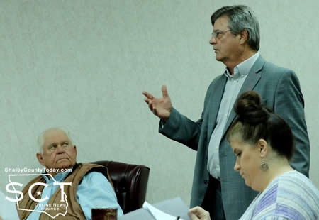
"We have been reporting, for some unknown reason, the Road and Bridge tax as a Farm to Market Flood Control tax the way it was coded in our software," said Bobby Pigg, Shelby County Appraiser. "It made this jump out at the Comptroller's Office."
He explained you can't have a $3,000 state mandated exemption and an optional exemption as well on Farm to Market Flood Control or the Road and Bridge tax.
"If I change the coding to say it's a Road and Bridge Tax, it's going to kick out what's called an EAR submission which our electronic submission that we do to the Comptroller's Office," said Pigg.
Pigg explained they are non-compliant with the property tax code by granting the $3,000 state mandated exemption. He requested the commissioners acknowledge he would have to make the needed changes for the upcoming tax year.
"It boils down to $3,000 state mandated exemption is about $2.39 for every homestead out there, anybody that has a homestead has been in the past getting a $3,000 state mandated exemption," said Pigg. "It's probably cost y'all on the special Road and Bridge tax somewhere in the neighborhood of $14,350 a year."
A motion carried to remove the $3,000 standard exemption on a homestead.
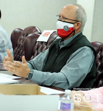
Shelby County Commissioners heard a report from Sheriff Kevin Windham during their meeting Wednesday, February 24, 2021.
Sheriff Windham gave the commissioners an update on the department, and expressed appreciation to Lt. Tanner Peace and Chief Deputy Ruth Gonzalez on going above and beyond on their duties.
Since taking office January 1, 2021, Sheriff Windham informed the court of the following statistics.
- 1,273 calls for service
- Jail population of 44 inmates: 37 male inmates and seven female inmates, with the total jail capacity for 66
- 98 arrests
- 102 reports taken by deputies including information, arrest reports, and those needing to be investigated
- Sheriff's Department currently has 21 vehicles, 17 assigned, four not assigned
Four of the vehicles in service at the Sheriff's Department are between 0-100,000 miles, and he informed the commissioners, any new vehicles have been rotated into patrol to refresh those vehicles in use.
Eight vehicles utilized by the department have between 100,000 and 200,000 miles on them and four of them are running over 200,000 miles. One vehicle has in excess of 300,000 miles.
"Four that we currently have parked is two of our older Crown Victorias, and then we've got our transport van and then we have the old silver truck, it's parked," said Sheriff Windham
Sheriff Windham described for the commissioners some new changes to the deputy uniforms.
"You've probably noticed we have purchased new uniform shirts. We have went back to the more traditional deputy uniforms," said Sheriff Windham.
Windham stated the Sheriff's Department has been able to purchase six new vests for patrol officers, and he shared several vests had aged out a long time ago.
"Some of them was 20 years old, they have a five year life span on them," said Sheriff Windham. "So we were able to find the money to purchase those and we want to thank Mr. Clint [Porterfield] and Mrs. Ann [Blackwell], because they're the ones that helped us find these funds that we need."
Sheriff Windham remarked on the difficulty in locating ammunition; however, the Sheriff's Department has been able to find the necessary ammunition for training and qualifications of officers, as is required.
"We have been able to use the AFIX program for better use in identifying better suspects by prints," said Sheriff Windham. "It's a wonderful, wonderful system to have."
The gate on a fence which surrounds the Sheriff's Department compound is not functioning just yet and there are plans to find someone to make the gate operate properly.
Sheriff Windham stated there are continued issues with the radio communications at the Sheriff's Department. It was already known the newly installed console was not going to fix all issues, but the Sheriff said he would be meeting with Texas Premier Communications who has stated they have found a solution to the radio communication problems.
Social media is being utilized by the Sheriff's Department and Sheriff Windham said they are trying to keep it updated. He stated the statistics for the Facebook page from January 27-February 24 indicates there had been 2,093 views, 473 likes and posts have reached 51,862 people, and 531 followers.
"The reason we're doing this is to portray the transparency of our department and keep our citizens informed," said Sheriff Windham.
Sheriff Windham informed the commissioners there are several part-time positions in the dispatch they are trying to transition to full-time, as well as some in the jail.
Judge Harbison remarked the lock issue has been resolved and asked Sheriff Windham if Texas Premier Communications had gotten the new antenna for volunteer fire department dispatch yet.
Sheriff Windham said the radio communications staff were behind at that time as a result of the ice storms, but they were still catching up.
In light of the $55,760 price tag the commissioners approved to repair the radio console at the Sheriff's Department in October 2020 Roscoe McSwain, Commissioner Pct. 1, asked if continued issues with the radios involved fire departments or Sheriff's Department radios.
"The way they're explaining it to me is the terrain. They say that we're sitting down like in a bowl, is what it is, but we've been exploring the solutions and I'm pretty excited when they called me the other day and said 'we got a solution," said Sheriff Windham. "Now what that solution entails, I have no idea at this time."
Related Article: Shelby County Establishes Pretrial Intervention Fund
Agenda items approved during the February 24 meeting include:
1. Pay weekly expenses.
2. Current payroll.
3. Annual County Investment Policy.
4. Designate a County Investment Officer.
5. Take action to revise the tax exemptions for the Road and Bridge Tax per Property Code, Section 11.13.
6. Amend the pretrial diversion budget by $11,000, and $17,500 to be re-allocated in the drug court program for technology infrastructure upgrades, computer replacements, laptop replacement, training and travel for staff and office supplies.
7. Adjourn.

Agenda items approved during the February 24 meeting include:
1. Pay weekly expenses.
2. Last week's Payroll.
3. Ratify and continue the Declaration of Disaster regarding the Winter Storm 02.2021.
4. Commissioner Pct. 4 to take bids on Kobelco Excavator through online auction.
5. Adjourn.
March 9, 2021 - The Texas DSHS Covid-19 Dashboard updated Tuesday with 2 new cases, 1 new recovery, and a new estimated active case count of 88 on March 9, 2021. Of the new active cases, 1 was a new confirmed case and 1 was a new probable case.
March 9th (12:25pm) Numbers: (changes since March 8th)
Total Confirmed Cases - 880 (1 new case)
Total Probable Cases - 664 (1 new case)
Total Fatalities - 59
Total Estimated Active Cases - 88
Total Estimated Recovered - 1,397 (1 new)
March 9, 2021 - Attorney General Ken Paxton today issued a Civil Investigative Demand (CID) to Intercontinental Gas Exchange, a natural gas exchange that saw massive price increases during the February winter storm that swept through Texas.
“As we learn more about what drove pricing spikes during the recent winter storm disaster, I am expanding the scope of my investigation to include the natural gas industry as well as electricity providers,” said Attorney General Paxton. “These massive price increases impacted businesses and consumers alike and will have long term effects on Texas. Hardworking Texans who pulled together to get their communities through this disaster deserve transparency and justice.”
Two weeks ago, Attorney General Paxton issued 12 CIDs to power companies seeking information related to power outages, emergency plans, energy pricing, and more.
Read a copy of the CID to Intercontinental Gas Exchange here.
March 9, 2021 - Officials with the National Forests and Grasslands in Texas, Sabine National Forest, have advised a prescribed burn, location in the East Hamilton Area north of Highway FM 2261, 1,648 acres (Block A).
Winds are predicted from the South 6 mph, Gusting to 16 mph.
Also, be advised a long range drift may affect some of the areas.
March 8, 2021 - The Texas DSHS Covid-19 Dashboard updated Monday with 3 new probable cases, 1 new recovery, and a new estimated active case count of 87 on March 8, 2021.
March 8th (2:25pm) Numbers: (changes since March 6th)
Total Confirmed Cases - 879
Total Probable Cases - 663 (3 new cases)
Total Fatalities - 59
Total Estimated Active Cases - 87
Total Estimated Recovered - 1,396 (1 new)
Pages