

The story headline links to a better view of the story and share features.


News
May 19, 2019 - Tom Bellmyer, Precinct 4 Commissioner, reports on county roads which have flooding and/or damage
- REOPEN - CR 4323 currently flooded at all three bridge crossings. As a result, he is closing the section of roadway within which the bridges are contained because the areas are almost impassable with a truck.
- CR 4694 is closed due to a cuvert completely washed out by flood waters at the section between CR 4699 and CR 4726. Expect a minimum of a couple of weeks for the repair to be made.
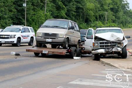
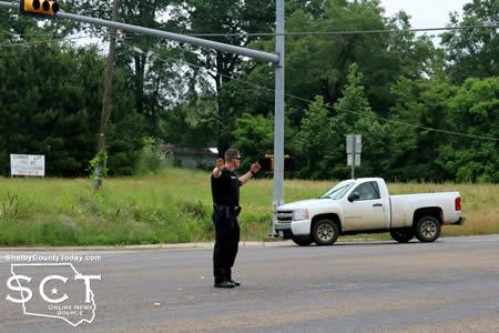
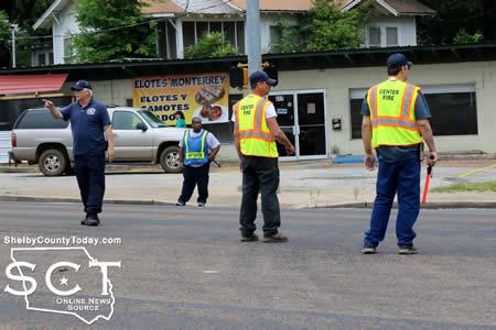
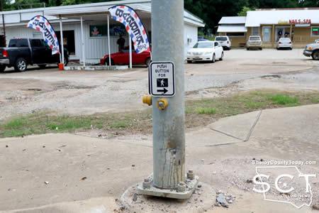
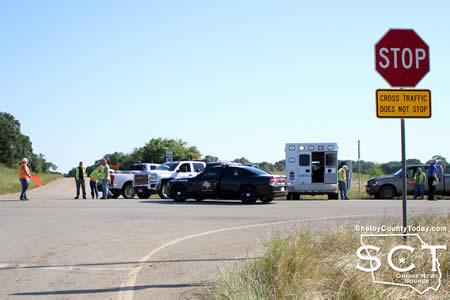
May 19, 2019 - Hurst Street in Center at the intersection of Wheeler Street was the scene of a major traffic incident, sending all involved to the emergency room May 18, 2019.
When law enforcement first arrived on scene, debris from vehicles was strewn across the roadway and witnesses to the event were seeing to the drivers and passengers involved until ambulances could arrive.
One vehicle with a trailer was resting at the traffic pole adjoining the north side of the Hurst and Wheeler Street intersection. An SUV involved in the crash was directly across the roadway on the north side of the Hurst Street and Arcadia Drive intersection.
Just as ambulances began to move in on the location, Center Fire Department Firemen occupied the roadway to divert traffic around the incident.
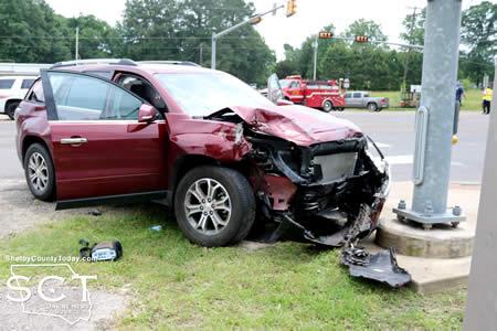
According to Center Police Officer Chris King, at 11:30am a red 2016 GMC Acadia driven by Marjorie Boswell Davis, 89, of Tenaha was southbound on Hurst Street (U.S. 96) and had stopped at the traffic light to turn left onto Wheeler Street.
Billy Eli Paddie, 70, of Center was at that time northbound on Hurst Street driving a white 1996 Chevrolet C1500 pulling a trailer with a van on the back when Davis turned left on an unprotected turn signal.

As the Acadia failed to yield, the C1500 truck was unable to stop in time and it struck the Acadia sending it spinning around and across the north and southbound traffic lanes coming to rest at the traffic light pole.
The truck continued north and collided head-on with the traffic pole at the Wheeler Street intersection and the weight of the trailer behind it spun the truck around before the trailer disconnected and both came to rest.

Davis and her passenger Robert Glenn Davis, Sr., 89, of Tenaha as well as Paddie and his passenger Jennifer Suzanne Paddie, 44, of Center were all transported by ambulance to Nacogdoches Medical Center - Shelby Emergency Department for treatment of their injuries.
No further information is available at this time.

Update: As of 3 PM on Sunday, May 19th, Deep East Texas Electric Cooperative is reporting approximately 1,450 members without power after overnight storms. Crews are working to restore power as quickly as possible.
San Augustine Co: 500 Members
Shelby Co: 390 Members
Nacogdoches Co: 250 Members
Newton Co: 213 Members
Sabine Co: 90 Members
Jasper Co: 5 Members
May 19, 2019 - As of 10am on Sunday, May 19th, Deep East Texas Electric Cooperative is reporting approximately 2,780 members without power after overnight storms. Crews are working to restore power as quickly as possible.
- San Augustine Co: 990 Members
- Shelby Co: 830 Members
- Nacogdoches Co: 640 Members
- Sabine Co: 190 Members
- Newton Co: 150 Members
- Jasper Co: 10 Members
Above all, DETEC encourages everyone to keep safety a priority. Should you encounter a downed line, consider it live and dangerous.
To report your outage, please call 1-800-392-5986.
Thank you for your patience and understanding.
May 19, 2019 - The U.S. Highway 59 overpass north of TImpson is passable again as the flooding has receded.
Travelers are urged to use caution, expect possible travel delays, and take alternate routes to avoid flooded roadways.
- County Road 1245 in Aiken Community is currenlty flooded and impassable as well at one location. Use caution when traveling this area.
- FM 415 at SH 87 south of Timpson is also reported to have two feet of water across the roadway.
- Tenaha is also reported to have flooding at the underpass on U.S. 59. Travelers are urged to use caution here as well.
- Flooding on Hwy 7 West near Excelsior school and tree down blocking entire highway.
- Trees are also down across the road in several locations on SH 87 South just outside Shelbyville.
May 19, 2019 - Tornado watch 189 remains valid until 2am CDT Sunday for the following areas in Louisiana this watch includes 15 parishes in north central Louisiana: Caldwell, Grant, Jackson, La Salle, Lincoln, Ouachita, Union, Winn.
In northwest Louisiana: Bienville, Claiborne, De Soto, Natchitoches, Red River, Sabine, Webster in Texas this watch includes 6 counties.
In northeast Texas: Angelina, Nacogdoches, Panola, Sabine, San Augustine, Shelby.
This includes the cities of Arcadia, Bernice, Carthage, Center, Clarks, Colfax, Columbia, Coushatta, Dry Prong, Farmerville, Gibsland, Grayson, Haynesville, Hemphill, Homer, Jena, Jonesboro, Logansport, Lufkin, Mansfield, Many, Martin, Midway, Minden, Monroe, Montgomery, Nacogdoches, Natchitoches, Olla, Pineland, Pleasant Hill, Ringgold, Ruston, San Augustine, Springhill, Stonewall, Winnfield, and Zwolle.
May 18, 2019 - Severe Thunderstorm Warning for De Soto Parish in northwestern Louisiana, Southwestern Caddo Parish in northwestern Louisiana, Northwestern Sabine Parish in northwestern Louisiana, Eastern Panola County in northeastern Texas, Shelby County in eastern Texas, Northern San Augustine County in eastern Texas until 1:15am CDT.
At 11:36pm CDT, severe thunderstorms were located along a line extending from near Deberry to 12 miles east of Carthage to near Joaquin to 7 miles west of Neuville to 6 miles north of Lufkin, moving east at 35 mph.
HAZARD...Golf ball size hail and 70 mph wind gusts.
SOURCE...Radar indicated.
IMPACT: People and animals outdoors will be injured. Expect hail damage to roofs, siding, windows, and vehicles. Expect considerable tree damage. Wind damage is also likely to mobile homes, roofs, and outbuildings.
Locations impacted include Nacogdoches, Carthage, Center, Tenaha, Timpson, Garrison, Pinehill, New Salem, Trawick, Sacul, Douglass, Minden, Cushing, Appleby, Mount Enterprise, Reklaw, Gary City, Stockman, Lilbert and Dotson.
PRECAUTIONARY/PREPAREDNESS ACTIONS...
A Tornado Watch remains in effect until 2:00am CDT for northwestern Louisiana and eastern and northeastern Texas.
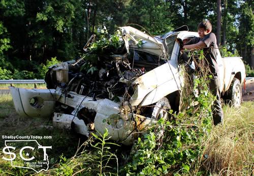
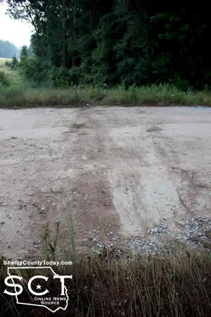
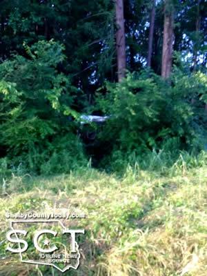
May 17, 2019 - A pickup truck involved in a major crash was located off State Highway 7 West Friday, May 17, 2019 with no driver to be found.
As the vehiicle was being removed at around 8am from the treeline it crashed into, an acquaintance of the driver arrived at the scene and the driver returned not long afterward.
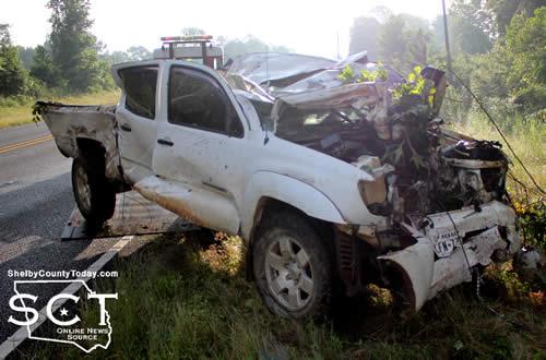
According to Texas Department of Public Safety State Trooper Keith Jones, at approximately 4:30am a white 2008 Toyota Tacoma pickup truck driven by Alan Figueroa, 24, of Nacogdoches was eastbound on SH 7 near CR 1206.
Figueroa stated he fell asleep while driving. The truck traveled straight through a curve in the roadway and left to the right before jumping a private driveway and going airborne. The truck then crashed into a tree in a woodline and came to rest on its side with major damage.
Injuries were not reported which resulted from the crash.

Figueroa was issued citations for fail to drive in a single lane and no driver's license.
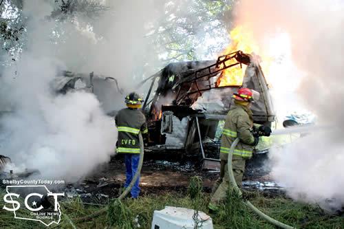
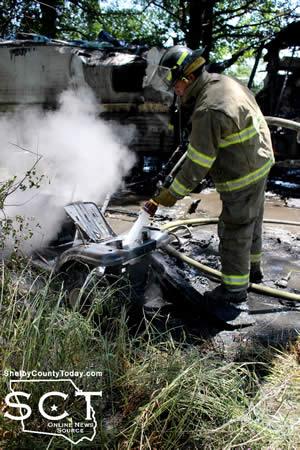
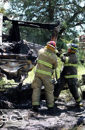
May 17, 2019 - A property off FM 2468 just near Loop 500 was the scene of several fires Wednesday, May 15, 2019, which involved a boat and two travel trailers and a lawn mower.
Center Fire Department firemen began fighting the fire after they were dispatched at 11:24am, dragging hoses to a location in the middle of the flaming objects.
Firemen were able to knock back the flames, putting out the boat and the campers in a short time.
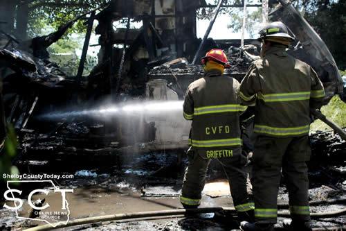
According to the Center Fire Department the owner of the property, Bobby Adams, was working on his boat motor when a fire ignited. The fire then spread from the boat to both of the travel trailers.
It appeared the owner moved the boat from in between the trailers with a tractor; however, all had already caught on fire.
May 17, 2019 - The Jury that was summoned for Monday, May 20, 2019, for the 273rd District Court, Honorable James A. Payne, Jr. presiding, has been cancelled.
All cases scheduled have been resolved or passed.
Anyone receiving a jury summons for this day is released until the receive a future summons.
Lori Oliver
District Clerk
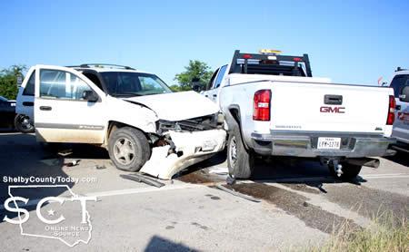
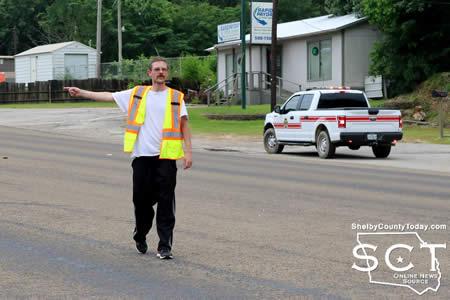
May 16, 2019 - Loop 500 and the intersection of FM 2468 was the scene of a two-vehicle crash involving a white SUV and a pickup truck which was part of a construction crew resurfacing portions of Shelby County roadways.
Texas Department of Public Safety State (DPS) Troopers were dispatched to the location in the morning on May 15, 2019.
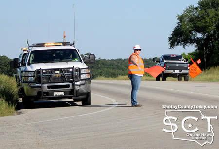
According to Texas DPS Trooper Jonathan Stinson, at around 8:15am a white 2019 GMC pickup truck owned by Lion Mark Construction of St. Louis Missouri and driven by Megan Christina Reynolds, 18, of Missouri was southbound on State Loop 500.
At that time the GMC made an unsafe lane change to the left in the middle of the intersection with FM 2468. A white 2004 Chevrolet Trailblazer driven by Deborah Alain Murray, 64, of Timpson was also southbound at that time, and as a result of the unsafe lane change, struck the driver's side of the pickup truck.
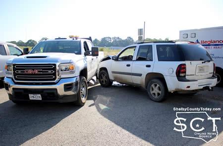
Reynolds and Murray were transported by ambulance to Nacogdoches Medical Center for treatment of possible injuries. Reynolds' passenger Mindy Lynn Hendrn, 25, of Arkansas was taken by ambulance to Nacogdoches Medical Center - Shelby Emergency Department for possible injuries.
Reynolds was issued a citation for turn when unsafe.
Pages