

The story headline links to a better view of the story and share features.


News
June 27, 2025 - Boil Water Notice Rescinded
On June 18, 2025, the Texas Commission on Environmental Quality required the City of Tenaha public water system, PWS ID NO. 2100002, to issue a Boil Water Notice to inform customers, individuals, or employees that due to conditions which occurred recently in the public water system, the water from this public water system was required to be boiled prior to use for drinking water or human consumption purposes.
The public water system has taken the necessary corrective actions to restore the quality of the water distributed by this public water system used for drinking water or human consumption purposes and has provided TCEQ with laboratory test results that indicate that the water no longer requires boiling prior to use as of June 27, 2025.
If you have questions concerning this matter, you may contact Stacy Cranford at 936-248-3841 or at 238 North George Bowers Drive Tenaha, Texas 75974.
June 18, 2025 - Due to a Line Break, the Texas Commission on Environmental Quality has required the City of Tenaha PWS ID NO. 2100002 public water system to notify all customers to boil their water prior to consumption (e.g., washing hands/face, brushing teeth, drinking, etc). Children, seniors, and persons with weakened immune systems are particularly vulnerable to harmful bacteria, and all customers should follow these directions).
To ensure destruction of all harmful bacteria and other microbes, water for drinking, cooking, and ice making should be boiled and cooled prior to use for drinking water or human consumption purposes. The water should be brought to a vigorous rolling boil and then boiled for two minutes.
In lieu of boiling, individuals may purchase bottled water or obtain water from some other suitable source for drinking water or human consumption purposes.
When it is no longer necessary to boil the water, the public water system officials will notify customers that the water is safe for drinking water or human consumption purposes.
Once the boil water notice is no longer in effect, the public water system will issue a notice to customers that rescinds the boil water notice in a manner similar to this notice.
Please share this information with all the other people who drink this water, especially those who may not have received this notice directly (for example, people in apartments, nursing homes, schools, and businesses). You can do this by posting this notice in a public place or distributing copies by hand or mail.
If you have questions concerning this matter, you may contact Stacy Cranford at 936-248-3841 or at 238 North George Bowers Drive Tenaha, Texas 75974.
June 27, 2025 - Commissioner Bellmyer reports that CR 4098 is now open to traffic and anyone that needs to travel on it as of 3:30pm Friday, June 27, 2025.
There remains three to four hours of cleanup to accomplish on Monday.
June 24, 2025 - A section of CR 4098 will be closed in Precinct 4 starting at 7am on Wednesday, June 25, 2025.
Tom Bellmyer, Commissioner Precinct 4, announces the closure on CR 4098 starting at the intersection of CR 4789 and continuing south for a 1/2 mile to the Holloway chicken farm.
The roadway is being closed for a bridge project and barricades will be in place.
(Update): Commissioner Bellmyer expects the roadway to be re-opened about midday on Friday.

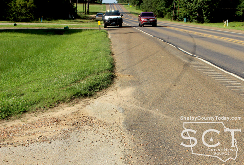
June 24, 2025 - U.S. Highway 96 South at FM 417 was the scene of a two-vehicle crash involving a truck tractor and a pickup truck on Thursday, June 19, 2025.
When emergency personnel arrived, the pickup truck remained in the middle of the roadway and the truck tractor was off the roadway and down an embankment where it had traveled through a fence before coming to rest.
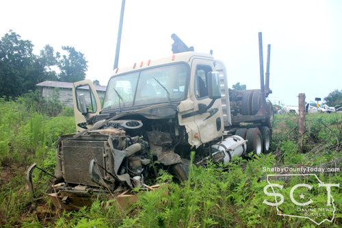
According to Texas Department of Public Safety State Trooper Cpl. David Shields, Jr. at approximately 5:55am a white 2013 Chevrolet 2500 pickup truck driven by Raymond Martin, 58, of Lubbock was northbound and crested a hill where a 2013 Freightliner log truck driven by Richard Livingston, 76, of Center was attempting to turn and back into a private driveway. Upon topping the hill Martin was unable to stop before colliding with the Freightliner.
Martin and Livingston were transported by ambulance to Shelby Emergency Department for treatment of their injuries.
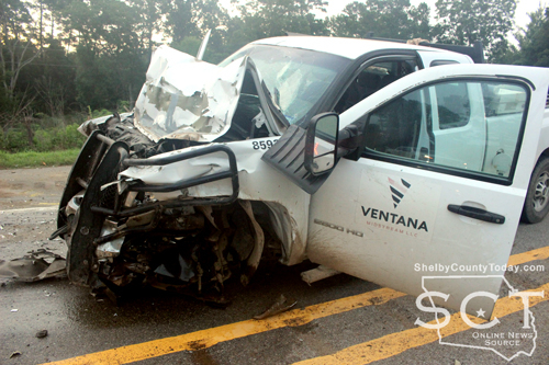
Trooper Shields was assisted at the scene by Sgt. Micah Rucker, Trooper Keith Jones and Trooper Ashlee White.

Jun 24 2025 - A strong thunderstorm will impact southwestern Panola, southeastern Rusk, northern Nacogdoches, northwestern Shelby and east central Cherokee counties through 7:45pm.
At 7:03 PM CDT, Doppler radar was tracking a strong thunderstorm over
Garrison, or 15 miles northeast of Nacogdoches, moving northwest at
30 mph.
Hazard: Wind gusts up to 50 mph and pea size hail.
Source: Radar indicated.
Impact: Gusty winds could knock down tree limbs and blow around unsecured objects. Minor hail damage to vegetation is possible.
Locations impacted include: Nacogdoches, Henderson, Timpson, Garrison, Pinehill, Trawick, Sacul,
Minden, Cushing, Appleby, Mount Enterprise, Reklaw, Stockman,
Fairplay, Stewart, Chalk Hill, Lilbert, Dotson, Laneville, and Oak
Hill.
Precautionary/preparedness actions: If outdoors, consider seeking shelter inside a building.
This storm may intensify, so be certain to monitor local radio stations and available television stations for additional information and possible warnings from the National Weather Service.
June 24, 2025 - A Shelby County Grand Jury delivered four indictments on Thursday, June 19, 2025. The grand jury was impaneled for the June 2025 term of the 123rd/273rd Judicial District Courts.
Mtwakil Ibhrmie Saeed was indicted for murder, first degree felony. The indictment alleges, on December 24, 2024, Saeed intentionally or knowingly caused the death of Cordero Laquasto Wyatt by shooting him in the abdomen with a deadly weapon, a gun. (273rd Judicial District Court) (Related Article: Center PD Investigates Death Off Shelbyville Street; Arrests One On Murder Charge (Update))
Jacorey Atkins was indicted for aggravated assault with a deadly weapon, second degree felony. The indictment alleges, on January 6, 2025, Atkins recklessly caused bodily injury to Wilzayvian Atkins by stabbing him with a knife during an argument. (123rd Judicial District Court)
Ricki Dshain Dutton was indicted for possession of a controlled substance PG 1/1-B >=1G<4G, third degree felony. The indictment alleges on February 25, 2025, Dutton possessed methamphetamine, a controlled substance, in an amount of one gram or more but less than four grams, by aggregate weight including any adulterants or dilutants. (273rd Judicial District Court)
(Some of the following content contained within indictments is of a sensitive nature and may not be suitable for younger viewers.)
Donald R. Moore was indicted on two counts of indecency with a child sexual contact, second degree felony. The indictment alleges, on August 10, 2023, in each count involving separate complainants younger than 17 years of age and with intent to arouse or gratify his sexual desire, Moore engaged in sexual contact by causing the complainants to touch his genitals. (123rd Judicial District Court)
Indictments and Information are not a conviction, and are a matter of public record. All individuals are presumed innocent until found guilty in a court of law.
June 24, 2025 - Following much discussion and careful consideration, the City of Joaquin City Council Members voted to approve an increase to the City’s Water, Sewer, and Gas Rates at the June 17, 2025, City Council Meeting.
The City Council is deeply committed to managing costs and maintaining operations while upholding its commitment to a sustainable future. As part of our ongoing commitment to providing reliable and sustainable services, we periodically review our rates to ensure they align with the cost of delivering utilities to your home and/or business.
As you are probably aware, prices for most utilities, supplies, products, and materials have continued to rise across the country. The same reigns true for the Water, Wastewater, and Gas Department’s operating expenses, including the parts and materials needed to keep our water system, gas system, and wastewater system running properly and efficiently, and meeting regulatory standards.
The Council’s decision to approve this increase was not easily decided. Numerous things were considered during the discussion, including information about the City’s eligibility to apply for various grants. For example, grant assistance is based on the number of people served by the water supply, the number of wells a groundwater supply operates, and/or the source water susceptibility determination, among other things. Applicants are ranked and qualification is determined by a points system where points are awarded for things such as total population, unemployment, average household income, percentage of population served, and water rates. The ability to secure grants such as this would help to ensure continued improvements such as replacing aging infrastructure and facilities, in turn, causing fewer service interruptions. Water rate increases have been relatively modest over the past years. Ensuring that those rate increases remain modest and justifiably necessary is an ongoing objective for City Council Members.
The rate increase that was approved on June 17, 2025, and will become effective on August 1, 2025, is as follows: The base or minimum monthly usage rate for water will increase $5, and the gas will increase $5. There will not be an increase in Wastewater at this time.
If you have questions about the rate increase, your water bill, or other utility questions, please contact the City of Joaquin Utility Department at 936-269-3021.
The notice is posted as required under Government Code Section 551.041. For more information or for a copy of the Open Meetings Act, please contact the Attorney General of Texas at 1-800-252-8011 or the City Secretary at 936-269-3021.
Posted by Cheryl Green on June 24, 2025 at 10:45am.
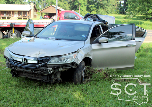
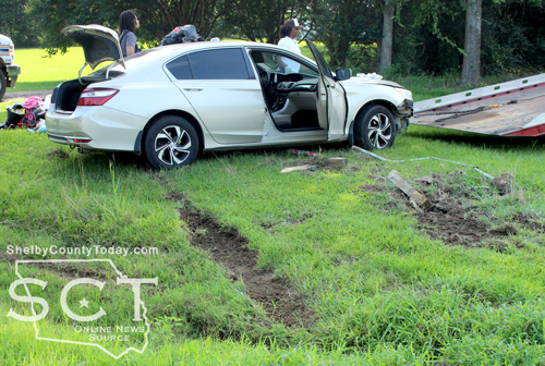
June 20, 2025 - Emergency responders were dispatched to State Highway 7 (SH7) East and CR 3001 around 4:40pm on June 17, 2025. Joaquin Volunteer Fire Department firefighters responded to the scene to assist, as well as Shelby County Sheriff's Deputies.
According to the Texas Department of Public Safety (DPS), a beige 2016 Honda Accord driven by Brianna Palmer, 26, of Mansfield, La.was traveling west. It is reported that Palmer took evasive action to avoid a piece of debris, a bucket. that was in the roadway. The Honda began to side skid, left the roadway, and struck a monument that was off the roadway.
Parker was medically evaluated at the scene by EMS personnel and was reported to have not been injured.
According to DPS, this is an ongoing investigation, and no further information is available at this time.
The crash was investigated by DPS Trooper Matt Chandler.
June 20, 2025 - Due to a power outage in Center, the Shelby County Courthouse and County Offices closed at noon on Friday, June 20, 2025. All offices will reopen on Monday, June 23rd with regular business hours. Courthouse regular business hours are 8am to 4:30pm.
As of 12:45pm, the power in Center has been restored.
June 20, 2025 - The second power outage this week for Center happened around 10:36am Friday, June 20. Swepco reports 3,030 customers are out of power and gives an estimated restoration time 3:00pm. The outage on Wednesday gave an estimated restoration time of 2pm but power was restored just before noon.
The National Weather Service, Shreveport, Louisiana has Center under a heat advisory from 11am until 7pm today. Heat index values between 105-109 are expected. Hot temperatures and high humidity may cause heat illnesses. Be sure to drink plenty of fluids and stay out of the sun. Check up on relatives and neighbors.

June 20, 2025 (1pm) - Shelby County Sheriff Chief Deputy Mike Hanson released the name of the individual who drowned in Lake Timpson to be Gregory Parker who was 43 years old and from Timpson. Hanson advised Parker and a friend were out on the lake in separate kayaks when the friend heard Parker "holler out." Before the friend could get to Parker, he went under the water for an unknown reason. Search teams were finally able to locate him near the location where he went in the water after Texas Game Warden Sam Anderson saw Parker's knee on sonar equipment. The lake is full of downed trees from recent storms along with vegetation which complicated the recovery efforts.
An updated list of agencies and individuals who assisted with the search: DeSoto Parish Fire District #1 Dive Team, San Augustine Fire Department Dive Team; Shelby County Sheriff Gerald Corbell; Shelby County Chief Deputy Mike Hanson; Shelby County Sheriff's Office Investigative Division, Patrol, and Jail Staff; Shelby County Constable Precinct 5 Constable Josh Tipton; Texas Department of Public Safety Highway Patrol Troopers; Texas Department of Emergency Management; Texas Game Wardens; Nacogdoches Police Department; Shelby County Precinct 4 Commissioner Tom Bellmeyer; Shelby County Constable Precinct 3 Constable Roy Cheatwood; Robin and Duncan Connell with Bink's Timpson Quick Stop; Hudson Volunteer Fire Department Cadaver K-9 Unit; as well as several citizens who assisted with their own boats and sonar equipment.
The Shelby County Sheriff's Department thanks all who assisted with the search and recovery operation and with bringing closure to Parker's family.
Recovery Teams Locate Missing Individual at Lake Timpson
June 20, 2025 (10am) - On day three of the search for a missing individual in Lake Timpson, Shelby County Sheriff Gerald Corbell reports the victim was located around 9:30am Friday morning by searchers. Pct. 5 Justice of the Peace Tracy Broadway was called to the scene to perform the inquest and the body was sent to Dallas for an autopsy.
During the search agencies from Shelby County and surrounding counties came to assist including Nacogdoches Police Department, DeSoto Parrish Dive Team, San Augustine Fire Department Dive Team, Texas Parks and Wildlife, Texas Department of Public Safety Patrol officers, and the Shelby County Sheriff's Department. Along with the agencies helping, Sheriff Corbell mentioned there were many citizen volunteers who came to help. The show of support from the community was tremendous.
The identity of the victim will be added once it has been released.
June 18, 2025 - Timpson Lake outside of Timpson is the location of a search for an individual involved in a boating incident on Wednesday, June 18, 2025.
Emergency personnel were notified around 9:15am. Texas Game Wardens and Shelby County Sheriff’s Department deputies are on the water in boats still searching as of 1:15pm.

Shelby County Sheriff’s Department personnel including Sheriff Gerald Corbell, Chief Mike Hanson, Jail Administrator Tiffany Ryals and Araceli Garcia were on scene, as well as Texas Department of Public Safety and Texas Department of Emergency Management.
More information will be updated as it becomes available.


Pages