


March 23, 2023 - The National Weather Service, Shreveport, LA issued the following Hazardous Weather Outlook at 6:14am on Thursday, March 23, 2023.
This Hazardous Weather Outlook is for south central Arkansas, southwest Arkansas, north central Louisiana, northwest Louisiana, southeast Oklahoma, east Texas and northeast Texas.
Today and tonight - An isolated severe threat is possible this evening, as scattered showers and thunderstorms develop over Southeast Oklahoma, portions of extreme Northeast Texas, and adjacent sections of Southwest Arkansas. Also, can`t rule out some isolated flash flooding, brief heavy rainfall will be possible with some storms.
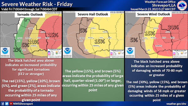
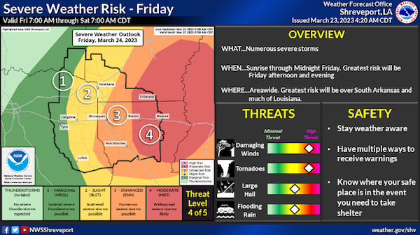
Friday through Wednesday - A much greater and significant severe weather threat will exist across much of the region Friday. Tornadoes, damaging winds, and large hail will be possible, with locally heavy rainfall also accompanying the stronger storms. The threat for severe weather should end late Friday evening as the storms exit the region to the east.
Additional showers and thunderstorms are possible Sunday as a warm front moves northward into the area. Isolated strong to severe storms can not be ruled out Sunday afternoon and evening over portions of Deep East Texas and adjacent North and Central Louisiana south of Interstate 20.
Spotter activation will likely be needed on Friday.