July 12, 2026 - Flood advisory in effect until 6:15pm CDT this evening.
Urban area and small stream flooding caused by excessive rainfall is expected in northeastern Nacogdoches County in eastern Texas, Central Shelby County in eastern Texas until 6:15pm CDT.
Impacts include minor flooding in low-lying and poor drainage areas.
Additional Details: At 5:17pm CDT, Doppler radar indicated heavy rain due to thunderstorms. This will cause urban and small stream flooding.
July 6, 2026 - Severe Thunderstorm Watch 467 is in effect until 10pm CDT July 6, 2026, for the following Texas Counties: Bowie, Camp, Cass, Gregg, Harrison, Marion, Morris, Nacogdoches, Panola, Rusk, Sabine, San Augustine, Shelby, Titus and Upshur.
June 19, 2026 - A Marginal Risk for severe thunderstorms exists for the entire Four State Region later today through this evening, as a complex of showers and thunderstorms spread east southeast across the area. Damaging winds and heavy rainfall are the main threats.
June 15, 2026 - At 10:39am, the National Weather Service in Shreveport has issued a Flash Flood Warning until 1:45pm for Sabine Parish in northwestern Louisiana, Northern Sabine County in eastern Texas, San Augustine County in eastern Texas, and Shelby County in eastern Texas.
March 27, 2026 - Elevated fire weather conditions are expected for all of our four state region which includes extreme southeast Oklahoma, southwest and south-central Arkansas, east Texas, and northern and central Louisiana.
Weather conditions will be favorable for wildfire growth.
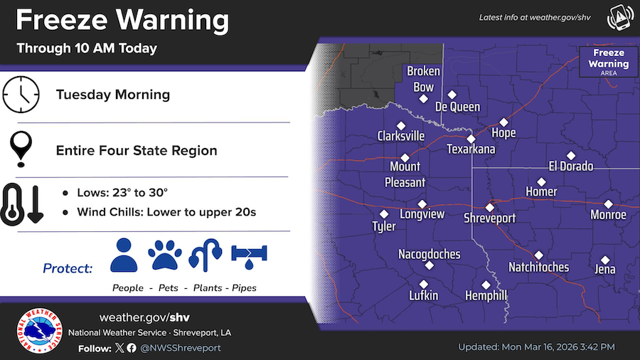
A cold airmass will settle over the region tonight, bringing widespread freezing temperatures by Tuesday morning. Consider taking steps to protect any early season sensitive vegetation.