Editor's note: Shelby County Today has received reports of heavy weather at 3:20pm in the Timpson area, with heavy debris including bricks becoming an issue on the Timpson square.
April 8, 2024 - (Update: 4:22pm) - A strong thunderstorm will impact northeastern Nacogdoches, southwestern Shelby and northwestern San Augustine counties through 4:45pm CDT.
At 4:08pm CDT, Doppler radar was tracking a strong thunderstorm over Martinsville, or 13 miles east of Nacogdoches, moving northeast at 30 mph.
Hazard: Wind gusts up to 40 mph and pea size hail.
April 8, 2024 - Flood Watch now in effect from 12-noon CDT today through Wednesday evening.
What: Confidence continues to increase in a widespread flooding event beginning late today and continuing through Wednesday caused by excessive heavy rainfall.
April 8, 2024 - Flood watch remains in effect from this afternoon through Wednesday afternoon.
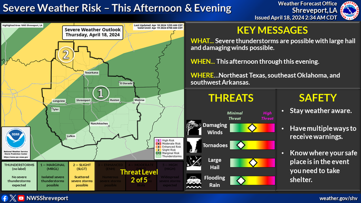
This Hazardous Weather Outlook is for south central Arkansas, southwest Arkansas, north central Louisiana, northwest Louisiana, southeast Oklahoma, east Texas and northeast Texas.
March 25, 2024 - Wind advisory in effect from 10am this morning to 7pm CDT this evening.
This Hazardous Weather Outlook is for south central and southwest Arkansas, for north central and northwest Louisiana, and for deep east Texas and portions of northeast Texas.
Day One - Today and tonight:
Please listen to NOAA Weather Radio or go to weather.gov on the Internet for more information about the Wind Advisory.
January 23, 2024 - The National Weather Service has issued a Flash Flood warning as of 2:27pm CST Tue Jan 23 2024 for the following counties (including Shelby), parishes and cities Caddo, Bossier, Webster, Claiborne, Lincoln, Union, De Soto, Red River, Bienville, Jackson, Ouachita, Sabine, Natchitoches, Winn, Grant, Caldwell, La Salle, Wood, Upshur, Marion, Smith, Gregg, Harrison, Cherokee, Rusk, Panola, Nacogdoches, Shelby, Angelina, San Augustine, Sabine, including the cities of Gibsland, Jonesboro, Bossier City, Jena, Mineola, Marshall, Lufkin, Hemphill, Colfax, Pineland, Mansfi