


Strong to severe thunderstorms are possible across portions of the ArkLaTex this afternoon through this evening.
April 18, 2024 - The National Weather Service, Shreveport, Louisiana issued a Hazardous Weather Outlook at 5:03am Thursday, April 18, 2024. This Hazardous Weather Outlook is for south central Arkansas, southwest Arkansas, north central Louisiana, northwest Louisiana, southeast Oklahoma, east Texas and northeast Texas.
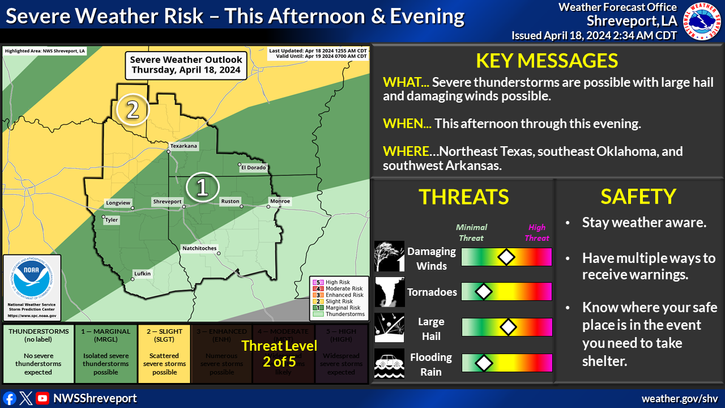
Today and tonight - A round of thunderstorms will be possible this afternoon and evening across northeast Texas, southeast Oklahoma, and southwest Arkansas ahead of a cold front. Some storms may be severe with damaging winds and large hail being the main threats.
Friday through Wednesday - Periods of locally heavy rainfall may be possible this weekend from Friday evening through Sunday.
Spotter activation may be needed for this afternoon and this evening.
This Hazardous Weather Outlook is for the following areas in Arkansas, Louisiana, Oklahoma, and Texas: Sevier, Howard, Little River, Hempstead, Nevada, Miller, Lafayette, Columbia, Union, Caddo, Bossier, Webster, Claiborne, Lincoln, De Soto, Red River, Bienville, Jackson, Ouachita, Sabine, Natchitoches, Winn, Grant, Caldwell, La Salle, McCurtain, Bowie, Franklin, Titus, Camp, Morris, Cass, Wood, Upshur, Marion, Smith, Gregg, Harrison, Cherokee, Rusk, Panola, Nacogdoches, Shelby, Angelina, and San Augustine.