National Weather Service Storm Prediction Center, Norman, OK
6:10am CST, Monday, January 2, 2017
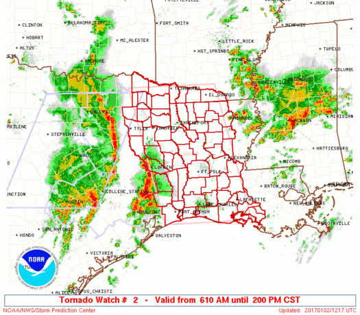
January 2, 2017 - The National Weather Service has issued a Tornado Watch 2 in effect until 2:00pm CST for the following Texas Counties: Angelina, Bowie, Camp, Case, Cherokee, Franklin, Gregg, Hardin, Harrison, Jasper, Jefferson, Marion, Morris, Nacogdoches, Newton, Orange, Panola, Red River, Rusk, Sabine, San Augustine, Shelby, Smith, Titus, Tyler, Upshur, and Wood.
The NWS Storm Prediction Center has issued a Tornado Watch for portions of Southern Arkansas, Louisiana, East Texas, Coastal Waters. Effective this Monday morning and afternoon from 610 AM until 200 PM CST.
Primary threats include... A few tornadoes possible, Scattered damaging winds and isolated significant gusts to 75 mph possible, Isolated very large hail events to 2 inches in diameter possible
SUMMARY...Multiple bands of strong to severe thunderstorms will steadily progress east-northeastward across the region this morning, with the possibility of semi-discrete supercells increasing ahead of multiple fast-moving convective lines and clusters. Damaging winds will be the primary risk, but a few tornadoes will be possible as additional moistening/destabilization occurs by late morning and midday in conjunction with strengthening low/mid-level winds.
The tornado watch area is approximately along and 85 statute miles east and west of a line from 5 miles north northeast of Texarkana AR to 40 miles south southeast of Lake Charles LA. For a complete depiction of the watch see the associated watch outline update (WOUS64 KWNS WOU2).
PRECAUTIONARY/PREPAREDNESS ACTIONS...
REMEMBER...A Tornado Watch means conditions are favorable for tornadoes and severe thunderstorms in and close to the watch area. Persons in these areas should be on the lookout for threatening weather conditions and listen for later statements and possible warnings.


