

The story headline links to a better view of the story and share features.


News
October 2, 2023 - Due to updating of the 2023 tax year data, the Shelby County Tax Office receipts will have to be hand written until the update is completed. Account information can be reviewed and printed. Thank you for your patience during this time.
Tax Office and Vehicle Registration will be closed Friday, October 6 and will resume normal hours on Tuesday, October 10th.
October 2, 2023 - Over the week of September 24th through 30th the Joaquin Volunteer Fire Department had just 2 calls. Here’s a summary of the week’s events.
Tuesday at 3:14pm a page came in for an individual with high blood pressure at a residence on Saddle Street. The JVFD med team was notified along with Allegiance EMS to get the patient the help they needed.
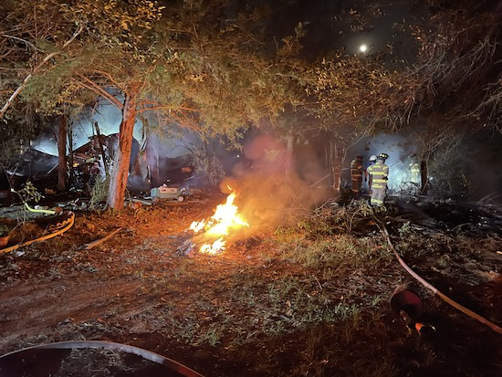
Saturday night at 8:47pm a call was received for a travel trailer on fire on County Road 3341. When JVFD units arrived they found a fully involved travel trailer with brush in the immediate vicinity also on fire. The firefighters on scene split into two hose teams and hit the fire from both sides, containing the blaze. Once all the hotspots were put out the scene was cleared. No one was inside the trailer at the time of the fire.
With that, this edition of the report will come to a close. The Joaquin Volunteer Fire Department hopes everyone has a great and safe week ahead.

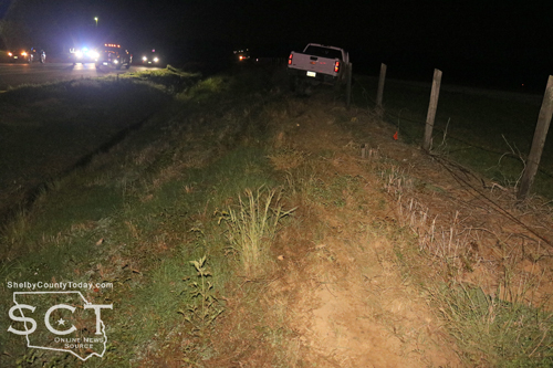
September 30, 2023 - Texas Department of Public Safety (DPS) Troopers are investigating a fatal auto-pedestrian crash that occurred on Farm-to-Market Road 2694, near the 760-mile marker, that occurred, September 29, 2023.
The preliminary crash investigation indicates that at approximately 9:10am, a 2011 GMC pickup driven by Samuel Furlow, 64, of Shelbyville was traveling west. It is reported that the pickup was traveling over a hilltop and struck a pedestrian that was walking in the westbound lane.
Furlow was not reported to have been injured.
The pedestrian, identified as Bobby Cassell, 60, of Shelbyville, was pronounced deceased on scene by a Justice of the Peace.
This is an ongoing investigation, and no further information is available at this time.
September 29, 2023 - The Shelby County Commissioners have lifted the burn ban during their meeting held September 29, 2023.
Roscoe McSwain, Commissioner Precinct 1, moved to lift the burn ban effective today, September 29, 2023, and Tom Bellmyer, Commissioner Precinct 4, seconded the motion.
Those who burn are encouraged to continue to be extremely careful and be aware they can still be liable for damage to others property should their fire get out of control and cause damage.
Editor's note: This article doesn't directly relate to Shelby County; however, it does demonstrate the dangers to everyone and that fraudsters can imppact us all no matter where they may be.
A jury in Los Angeles convicted three individuals for their roles in laundering proceeds of large-scale consumer fraud schemes through gift card transactions. Blade Bai, Bowen Hu and Tairan Shi were convicted of conspiracy to launder proceeds of wire fraud. Bai was also convicted of a separate money laundering conspiracy count.
As part of the scheme, fraudsters engaged in government-imposter scams and tech support scams. In a government-imposter scam, fraudsters contact consumers and impersonate government officials, such as officials with the Social Security Administration or local police officers. The fraudsters falsely claim that victims need to purchase gift cards to resolve an issue, often claiming that the victims are subject to a pending arrest warrant or that the victims have a problem with their Social Security number. In a tech support scam, fraudsters deceive victims into believing that there is a serious problem with the victim’s computer or with an online or mobile app account access and that the problem can only be resolved by paying substantial amounts through gift cards.
In this case, telephone scammers instructed victims to purchase gift cards from the retail store Target and provide the scammers with the account numbers and access codes listed on the gift cards. The defendants then distributed the numbers assigned to the gift cards to “runners,” who used the funds on the cards at Target stores (primarily in Los Angeles and Orange counties) to purchase consumer electronics, other gift cards and other items. In one instance presented as evidence at trial, runners acting on behalf of the defendants redeemed gift cards that originated from a victim in Illinois approximately 13 minutes after the victim purchased the cards. Through the purchases and other transactions at multiple Target stores, the defendants and their co-conspirators sought to conceal the fact that the gift cards had been originally funded with fraudulent proceeds.
“Defendants played a key role in victimizing American consumers,” said Principal Deputy Assistant Attorney General Brian M. Boynton, head of the Justice Department’s Civil Division. “This case is a testament to the commitment of the department and our partners to ensuring that all those who knowingly facilitate fraud face justice.”
“This investigation is a good example of law enforcement collaboration coming together to protect communities from fraudulent activities,” said Special Agent in Charge Eddy Wang of Homeland Security Investigations (HSI) Los Angeles “HSI and its partners on the El Camino Real Financial Crimes Task Force will continue to track down criminal organizations preying on innocent victims and ensure they are held accountable.”
“These defendants knowingly laundered the proceeds of a fraudulent scheme that targeted vulnerable citizens, including older Americans,” said Assistant Director in Charge Donald Always of the FBI Los Angeles Field Office. “This significant conviction should educate potential victims about the scam and send a message to anyone conducting similar schemes that the bureau and our partners are serious about combating this fraud. Anyone being asked to purchase a gift card in order to resolve a technical issue or to avoid an arrest should not spend money but instead, make a report to the FBI at IC3.gov.”
A fourth defendant, Yan Fu, had previously pleaded guilty and was sentenced to 20 months in prison.
Bai, Hu and Shi are scheduled to be sentenced on Jan. 26, 2024.
HSI and the FBI Los Angeles Field Office, West Convina Resident Agency investigated the case. The investigation was conducted under the auspice of HSI Los Angeles' El Camino Real Financial Crimes Task Force, a multi-agency task force comprised of federal and state investigators focused on financial crimes in Southern California.
The Social Security Administration, Office of the Inspector General also provided assistance during the investigation, as did the following: the Brea (California) Police Department, Glynn County (Georgia) Police Department, Fontana (California) Police Department, Charlotte-Mecklenburg (North Carolina) Police Department, Streamwood (Illinois) Police Department, Cleveland (Ohio) Police Department, Madera County (California) Sheriff’s Office, New York Police Department, Norwood (New Jersey) Police Department, Loudoun County (Virginia) Sheriff's Office, Waukesha County (Wisconsin) Sheriff's Department, Fremont (California) Police Department, Marin County (California) Sheriff’s Office, County of Hawaii Police Department, Henderson (Nevada) Police Department, Wilmington (Massachusetts) Police Department, Las Vegas (Nevada) Metropolitan Police Department, Lewisville (Texas) Police Department, Gardena (California) Police Department, Des Moines (Iowa) Police Department, Cobb County (Georgia) Sheriff’s Department, Millburn (New Jersey) Police, Wauwatosa (Wisconsin) Police Department, San Angelo (Texas) Police Department, Fairfax City (Virginia) Police Department and Virginia Beach (Virginia) Police Department.
Trial Attorneys Wei Xiang and Meredith Healy of the Civil Division’s Consumer Protection Branch and Assistant U.S. Attorney Monica Tait of the Major Frauds Section for the Central District of California prosecuted the case.
The Consumer Protection Branch and United States Attorney’s Office for the Central District of California are part of the Transnational Elder Fraud Strike Force, which investigates and prosecutes scams run by transnational criminal organizations, including mass mailing and telemarketing fraud scams.
If you purchased a gift card at the direction of a scammer, immediately call the gift card issuer and ask them to freeze the gift card numbers involved – and save your receipt and the gift card. Then, report the crime to the Federal Trade Commission at www.reportfraud.ftc.gov/#/ or 877-382-4357, to the FBI’s Internet Crime Complaint Center at www.ic3.gov, and to your local police department.
If you or someone you know is age 60 or older and has been a victim of financial fraud, help is standing by at the National Elder Fraud Hotline: 1-833-FRAUD-11 (1-833-372-8311). This Justice Department hotline, managed by the Office for Victims of Crime, is staffed by experienced professionals who provide personalized support to callers by assessing the needs of the victim and identifying relevant next steps. Case managers will identify appropriate reporting agencies, provide information to callers to assist them in reporting, connect callers directly with appropriate agencies and provide resources and referrals, on a case-by-case basis. Reporting is the first step. Reporting can help authorities identify those who commit fraud and reporting certain financial losses due to fraud as soon as possible can increase the likelihood of recovering losses. The hotline is open Monday through Friday from 10:00 a.m. to 6:00 p.m. ET. English, Spanish and other languages are available.
Additional information about the Consumer Protection Branch and its enforcement efforts may be found at www.justice.gov/civil/consumer-protection-branch.
Additional information about the U.S. Attorney’s Office for the Central District of California may be found at www.justice.gov/usao-cdca.
September 27, 2023 - The 47th Annual East Texas Poultry Festival is just days away. The actual Festival will be Thursday – Saturday, October 5th, 6th and 7th.
This year, San Augustine Street and Austin Street will be closed to thru traffic starting around 4:00 on Wednesday, October 4th. We will have 3 ticket booths this year – corners of San Augustine Street one at each end (same as last year) and an additional booth at the corner of Austin and Nacogdoches Street.
Below is the set-up schedule for tents, carnival etc.
- Coupon Booth – Tuesday, September 26th. This will be on inside of the square, next to the inner sidewalk across from The Forge. This will only affect a few parking spots on the inside square.
- Main tent concrete – Thursday, September 28th. This will affect all the inside of the square on San Augustine side and partial Austin Street (across from Citizens Bank, County Clerk’s office and All Hours Fitness)
- Main tents – Sunday, October 1st. This will affect all the inside of the square on San Augustine side and partial Austin Street (across from Citizens Bank, County Clerk’s office and All Hours Fitness)
- Carnival – Tuesday, October 3rd. Inside of the square – Shelbyville Street, Nacogdoches Street. Please DO NOT park on the inside of the square after 5pm on Tuesday, October 3rd.
Please arrange for alternate parking if you usually park on the inside of the square. Everything will be back to normal Sunday, October 8th.
Thank you for your assistance! Have a FUN Festival!!

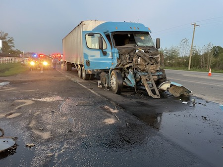
September 25, 2023 - State Highway 7 (SH7) East at the intersection of CR 1656 was the scene of a reported major two-vehicle crash Friday, September 22, 2023.
First responders to the scene of the crash were Center Police Department (CPD) officers and Center Fire Department (CFD) personnel. One pickup truck remained in the middle of the eastbound traffic lane and another involved had left the roadway and traveled through a fence at the edge of the Center Municipal Airport.
Accordng to the Texas Department of Public Safety (DPS), the preliminary crash investigation indicates that at approximately 10:15pm, a white 2012 Chevrolet pickup truck driven by Jose Avila, 23, of Center was traveling west on SH7. It is reported that a white 2020 Toyota pickup truck was traveling on FM 1656 and failed to yield to the Chevrolet at the stop sign, pulling into its path. The Toyota was struck by the Chevrolet on its front left.

The driver of the Toyota, identified as a 16-year-old female juvenile, was injured but refused treatment on scene. She was cited for failing to yield right-of-way at a stop sign. Her passengers, a 16-year-old and a 15-year-old, were not injured.
Avila and four passengers, a 16-year-old, a 17-year-old, a 7-year-old and a 12-year-old, were all uninjured. He was cited for not having a driver's license.
According to the DPS, there is no further information available.
Center Fire Department personnel remained on scene to assist with traffic control until the vehicle were removed, Shelby County Sheriff's Deputies were at the location to assist. The crash was investigated by DPS Trooper Chris Cain.
September 25, 2023 - Over the week of September 17th through 23rd the Joaquin Volunteer Fire Department had 6 calls. Here’s a summary of the week’s events.
Sunday at 12:14pm a call was received for a house fire on County Road 3199. Upon arriving on scene, the JVFD found that the fire was confined to just one bedroom and units were able to make a quick stop on it to save the rest of the house.

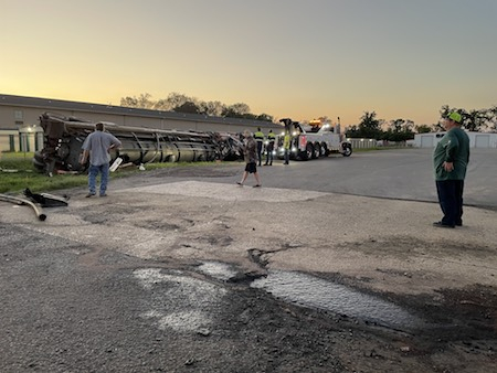
Sunday evening at 5:30pm a page came in for an accident involving two tractor-trailers on the Haslam Strip. When the Joaquin VFD arrived they found one of the rigs lying on its passenger side partially in a driveway to a saltwater disposal, with the other rig still in the roadway. The JVFD medical team went to work with Allegiance EMS to check out both of the drivers, while other members of the department provided traffic control. JVFD units were on scene for several hours while law enforcement investigated the crash and the wreckage was cleaned up. Both drivers were transported to separate hospitals for treatment of their injuries.
Tuesday, Wednesday, Thursday, and Friday all had a single medical call each, which included a seizure patient, person with severe back pain, person with chest pains, and a person with swelling in their arm and hand. In each case, the JVFD med team was notified as well as an ambulance service to help each patient.
With that, this edition of the report will come to a close. The Joaquin Volunteer Fire Department hopes everyone has a great and safe week ahead.
September 25, 2023 - The National Weather Service in Shreveport has issued a Severe Thunderstorm Warning for Southwestern Panola County in northeastern Texas, Southeastern Rusk County in northeastern Texas, Nacogdoches County in eastern Texas, Western Shelby County in eastern Texas, Angelina County in eastern Texas, Northwestern San Augustine County in eastern Texas, Southeastern Cherokee County in northeastern Texas until 12:45am CDT.
At 11:56 PM CDT, severe thunderstorms were located along a line extending from 6 miles northwest of Pinehill to 7 miles north of Nacogdoches to near Kennard, moving east at 40 mph.
Hazard: 60 mph wind gusts and quarter size hail.
Source: Radar indicated.
Impact: Hail damage to vehicles is expected. Expect wind damage to roofs, siding, and trees.
Locations impacted include Lufkin, Nacogdoches, Henderson, Center, Diboll, Hudson, Huntington, San Augustine, Tenaha, Timpson, Garrison, Wells, Melrose, Pinehill, Martinsville, Bland Lake, Neuville, Trawick, Woden, and Pollok.
PRECAUTIONARY/PREPAREDNESS ACTIONS...
For your protection move to an interior room on the lowest floor of a
building.

September 20, 2023 - Kraft Heinz is announcing a voluntary recall of approximately 83,800 cases of individually-wrapped Kraft Singles American processed cheese slices that were shipped to a limited number of customers.
The voluntary recall comes as a precaution after a temporary issue developed on one of our wrapping machines, making it possible that a thin strip of the individual film may remain on the slice after the wrapper has been removed. If the film sticks to the slice and is not removed, it could be unpleasant and potentially cause a gagging or choking hazard.
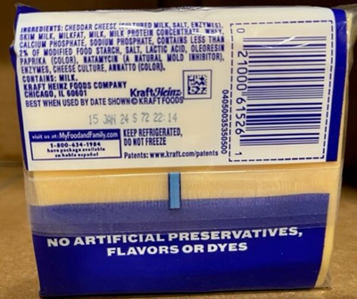
Only Kraft Singles American processed cheese slices with the case/package information below are affected. No other varieties or sizes are included in the recall.
The issue was discovered after we received several consumer complaints about finding the plastic stuck to a slice, including six complaints of consumers saying they choked or gagged in connection with the issue. No injuries or serious health issues have been reported.
Kraft Heinz has fixed the machine that wrapped the affected slices and all other processing machines have been thoroughly inspected.

Consumers who purchased these items should not consume them and can return them to the store where it was purchased for an exchange or refund. Consumers can contact Kraft Heinz from 9 a.m. to 6 p.m. Eastern Standard Time, Monday through Friday, at 1-800-280-8252 to see if a product is part of the recall and to receive reimbursement.
Kraft Heinz is committed to upholding the highest safety and quality standards and apologizes for this inconvenience.
Products included in the recall include 16 oz. Kraft Singles American Pasteurized Prepared Cheese Product with an individual package UPC of 0 2100061526 1 and a “Best When Used By” date of 10 JAN 24 through 27 JAN 24. Individual packages in this recall will contain an S and 72 in the Manufacturing code.
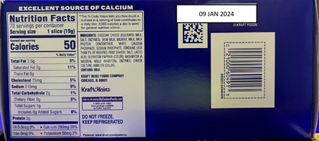
Also included in the recall are 3 lb. multipacks of Kraft Singles American Pasteurized Prepared Cheese Product with a carton UPC of 0 2100060491 3 and a “Best When Used By” of 09 JAN 2024 through 13 JAN 2024 and 16 JAN 2024.
Pages