

The story headline links to a better view of the story and share features.


News
May 13, 2022 - Shelbyville Street in Center just south of the railroad tracks was the scene of a two-vehicle crash Thursday, May 12, 2022.
According to Center Police Officer Spencer Anderson, at 4:24pm a tan 2007 Chevrolet passenger car driven by a 16-year-old minor driver was southbound on Shelbyville Street. At the same time a grey 2018 GMC Acadia driven by Renita Jones, 66, was also southbound.
The Chevrolet failed to control speed and struck the rear of the GMC, causing minor damage to both vehicles.
No injuries were reported and no citations issued as a result of the crash.

May 13, 2022 - State Highway 87 South just outside of Center was the scene of a two-vehicle collision Thursday, May 12, 2022.
Emergency responders with multiple agencies arrived at the scene of the incident just after 12:46pm.
According to Texas Department of Public Safety State Trooper Keith Jones, a white 2017 Hyundai Accent driven by Alyssa Charlene Channel, 20, was northbound on State Highway 87. At that time, a white 2016 Ford F-150 pickup truck owned by Tyson Foods and driven by Emily Marie Skains, 29, had slowed to make a left turn onto CR 1396.
Channel had turned her attention to her infant child in the back seat and the Hyundai collided with the rear of the Ford, causing damage to both vehicles.

Emergency medical services evaluated those involved in the crash and no injuries were reported.
Channel was issued citations for fail to control speed, no driver's license, and no proof of insurance.

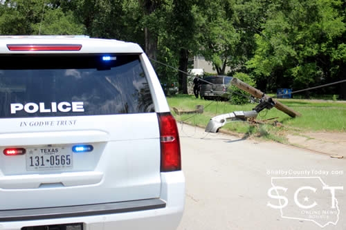
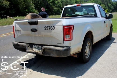
May 13, 2022 - Nacogdoches Street in Center was the scene of a single-vehicle crash Friday, May 13, 2022, involving an SUV striking a utility pole.
According to Center Police Officer John Clevenger, at around 1pm a tan 2003 GMC Yukon driven by LaTreveon Cartwright, 19, of Shelbyville was eastbound on Nacogdoches Street when his seat belt popped loose and hit him in the face, the GMC swerved to the right and struck the utility pole. The vehicle came to rest in a nearby yard.

A Shelby County Sheriff's Deputy was traveling Nacogdoches Street at the time the crash occurred and was immediately on the scene to check on Cartwright and divert traffic.
Center Fire Department personnel arrived to help divert traffic around the incident location. A nearby utility company was able to eventually dislodge the remnants of the utility pole from utility lines and remove debris from the roadway.

No injuries were reported as a result of the crash, and no citations were issued at that time.
The vehicle was towed from the scene.

May 13, 2022 - On May 9, 2022, the Texas Commission on Environmental Quality required the Five Way public water system, 2100008 to issue a Boil Water Notice to inform customers, individuals, or employees that due to conditions which occurred recently in the public water system, the water from this public water system was required to be boiled prior to use for drinking water or human consumption purposes.
The public water system has taken the necessary corrective actions to restore the quality of the water distributed by this public water system used for drinking water or human consumption purposes and has provided TCEQ with laboratory test results that indicate that the water no longer requires boiling prior to use as of May 13, 2022.
If you have questions concerning this matter, you may contact, Matt Di Verdi at 936-591-4346.
May 10, 2022 - Due to a broken water main the Texas Commission on Environmental Quality has required the FIVE WAY Water system, ID# 2100008 to notify customers that were without water 05/09/2022 on Hwy 7 E, FM 699, Spur 699, Airport RD, CR 3129 (anyone without water) to boil their water, prior to consumption (e.g., washing hands/face, brushing teeth, drinking, etc). Children, seniors, and persons with weakened immune systems are particularly vulnerable to harmful bacteria, and all customers should follow these directions.
To ensure destruction of all harmful bacteria and other microbes, water for drinking, cooking, and ice making should be boiled and cooled prior to use for drinking water or human consumption purposes. The water should be brought to a vigorous rolling boil and then boiled for two minutes.
In lieu of boiling, individuals may purchase bottled water or obtain water from some other suitable source for drinking water or human consumption purposes.
When it is no longer necessary to boil the water, the public water system officials will notify customers that the water is safe for drinking water or human consumption purposes.
Once the boil water notice is no longer in effect, the public water system will issue a notice to customers that rescinds the boil water notice in a manner similar to this notice.
Please share this information with all the other people who drink this water, especially those who may not have received this notice directly (for example, people in apartments, nursing homes, schools, and businesses). You can do this by posting this notice in a public place or distributing copies by hand or mail.
If you have questions concerning this matter, you may contact Matt Di Verdi 936-591-4346
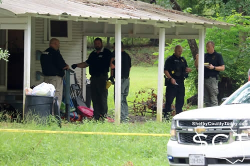
May 13, 2022 - A Shelby County jury returned two guilty verdicts and one not guilty verdict on May 11, 2022, in the trial of Zenas Montre Whitaker. Whitaker was charged with Aggravated Assault with a Deadly Weapon, Aggravated Kidnaping, and Aggravated Sexual Assault. The case was tried in the 273rd Judicial District Court, Judge Jim Payne presiding. Testimony began Monday afternoon and continued throughout Tuesday and part of Wednesday with both the State and the Defense presenting witnesses. After deliberating a little over an hour, the jury returned guilty verdicts for the charges of the Aggravated Assault with a Deadly Weapon and Aggravated Kidnapping. The jury returned a not guilty verdict on the Aggravated Sexual Assault. That same jury, after hearing more evidence about Whitaker’s criminal history in the Punishment trial, assessed punishment for the Aggravated Assault with a Deadly Weapon at 60 years in the Texas Department of Criminal Justice, Institutional Division, and a $10,000 Fine and 45 years in the Texas Department of Criminal Justice, Institutional Division for the Aggravated Kidnapping. Zenas Whitaker was represented by Marshall, Texas attorney Craig Fletcher, and the State of Texas was represented by Karren S. Price, Shelby County District Attorney, and Lynda K. Russell, Assistant District Attorney along with the assistance of Shawna Walker, Legal Assistant to the District Attorney.
On July 7, 2020, Whitaker broke into his ex-girlfriend’s home about noon and proceeded to beat her with an aluminum bat from which the end had been broken, creating jagged and sharp edges on the fat end of the bat. He also kicked her and even bit her. She was in the home with five children, all under the age of six, and all of this occurred with the children in the room watching. The photos of the crime scene were very graphic as there was blood everywhere, all over the floor, on the walls, on the furniture and even on some of the children. After beating her, per his testimony, he took their daughter who was two years old and the bat and headed to Nacogdoches County where he had lived most of his life. He further testified he left the baby’s mother there, believing she was not going to live, and knowing that he had also left four children there with her under the age of six, one of them being an infant. The victim reported that he had taken her cell phone which prevented her from being able to call for help. He testified that while he was driving through the Martinsville area, he threw both his cell phone as well as the victim’s out the window in an attempt to keep the police from finding him.
The Center Police Department reached out to law enforcement in Nacogdoches County and an Amber Alert was issued for the missing child who was only two years old. The Nacogdoches Sheriff’s Office, the Nacogdoches Police Department, the Texas Rangers and the FBI all assisted in the search for the child and Whitaker. Whitaker was located in Cherokee County, Texas. When the Nacogdoches County SWAT team had the home surrounded where they believed Whitaker to be, he came out of the home after they requested on a bullhorn that he surrender. The child was returned to her mother’s family as her mother was in the hospital being treated for the severe beating she had taken at the hand’s of Whitaker.
District Attorney Price proved that only a few weeks prior to the beating that occurred on July 7, 2020, Whitaker had sent multiple texts to the victim, threatening her, to the extent that the officer said it was obvious he was going to try to kill her. Both Ms. Price and Ms. Russell presented evidence that indicated Whitaker had been in trouble many times because of his violent nature. In fact, he was only 11 years old when he was charged with Aggravated Assault with a Deadly Weapon. Over the years after that, he was in trouble numerous times in Nacogdoches County for various crimes, several for which he was convicted, again involving assaultive behavior. Ms. Price told the jury that Shelby County would not tolerate this type of behavior in our community and that we were going to do something about it. She also said that law enforcement had done their job, her office had done theirs, and that the efforts had been made by all up to this point and now the outcome of those efforts were in the hands of the jury. She was very thankful that the jury took her words to heart and returned the verdicts that sent the message she wanted “Shelby County Will Not Tolerate This Type Of Behavior.”
Price contributes the verdicts to the hard work of the officers at the Center Police Department, the Shelby County Sheriff’s Department, the Nacogdoches Sheriff’s Office and Police Department, the Texas Rangers and the FBI and their ability to all work together to try to protect the citizens of Shelby County.

May 13, 2022 - A Shelby County jury has convicted Zenas Montre Whitaker Wednesday, May 11, of aggravated assault with a deadly weapon; and kidnapping following a three day trial regarding the July 2020 assault of a Center woman.
The trial was held in the 273rd Judicial District Court with Judge James Payne presiding.
After Karren Price, 123rd Judicial District Attorney, and Lynda K, Russell, Assistant District Attorney, and Craig Fletcher, criminal defense lawyer, each rested their case the jury convened as they considered three separate charges against Whitaker.
Following an hour of deliberation, the jury found Whitaker not guilty on the first charge of aggravated sexual assault.
The jury found him guilty on the charges of aggravated assault with a deadly weapon, first degree felony, and aggravated kidnapping, first degree felony.
The jury recommended 60 years in the Texas Department of Criminal Justice Correctional Institution Division and $10,000 for the aggravated assault with a deadly weapon conviction and 45 years in the Texas Department of Criminal Justice Correctional Institution Division and no fine for the aggravated kidnapping charge.
Upon sentencing, Judge Payne agreed with the jury recommendation and sentenced Whitaker with the jury's decision. Both sentences for Whitaker are to run concurrently.
Over three days, the jury heard testimony from medical professionals and law enforcement officers involved in the case which resulted from the June 7, 2020, attack.
A doctor from the Shelby County Emergency room, where she spent a couple hours following her attack, indicated the many injuries the victim had and a Sexual Assault Nurse Examiner (SANE) testified as to her interview with the victim later that night in the hospital.
The victim was beaten with a broken aluminum baseball bat, which was presented as evidence for the jury to view, and approximately eight inches of the end of the bat was missing. This created a menacing jagged end with sharp edges to it.
Jurors saw police body cam video during the trial depicting a bloody scene throughout the house, and the victim testified about her blood covering one of the children as that child was behind her on the couch in the living room during the assault.
Ultimately, when Whitaker was on the witness stand in his defense, he took full responsibility for the beating and the main part that differed relating to the bat was the prosecution argued he brought the bat with him while alternatively Whitaker claimed the broken bat was already in the house when he arrived.
"I can't give y'all any excuse about that day, what happened between me and [the victim]," said Whitaker. "Ever since I have been incarcerated and I have sat there and I have wondered myself why I would do something like that."
He stated he was truly sorry he had done that.
There was a Child Protective Services (CPS) case involving the victim, Whitaker and their child and she had been through a drug rehab program after which she stayed with her sister.
The victim was babysitting several children, as well as her own child, when the attack occurred. It began in the kitchen of the home where Whitaker began striking the victim with the bat and the assault then continued to the living room where the children were.
The beating with the baseball bat continued there, and at some point the victim ended up with her child in her hands and that's when she says Whitaker bit her hand when he went to leave and take their child. She related it was a common occurrence when they were in a relationship for Whitaker to bite her hands.
"The beatings have always been bad, but this was the worst time and I really thought this was the end for me, I really did," said the victim.
Related articles:
Center PD Updates on Investigation into Incident at Arcadia Road, Stephens Street; Suspect Arrest, Charges (Updated)
May 12, 2022 - The jury that has been summoned for Monday, May 16, 2022 for the 273rd District Court Honorable James A. Payne, Jr. presiding has been cancelled. All cases have been resolved or passed.
Anyone receiving a summons for that day is released from jury service until they receive a future summons.
Thank you,
Lori Oliver
District Clerk
Shelby County, Texas
May 11, 2022 — In honor of National Police Week, United States Attorney Brit Featherston will recognize the service and sacrifice of federal, state, local, law enforcement. This year, the week is observed Wednesday, May 11 through Tuesday, May 17, 2022.
“This week, we gather to pay tribute to the law enforcement officers who sacrificed their lives in service to our country,” said Attorney General Garland. “We remember the courage with which they worked and lived. And we recommit ourselves to the mission to which they dedicated their lives. On behalf of a grateful Justice Department and a grateful nation, I extend my sincerest thanks and gratitude to the entire law enforcement community.”
“Without the rule of law, the pillars of Constitution will not stand. At its most basic human level, the officer on the street is and must be the protector of the people, the one we turn to when danger or wrongs occur,” said U.S. Attorney Brit Featherston. “Encounters on the street with a police officer is often where the justice system is initiated and where our citizens (victim or accused) begin their journey to protect their life or property from harm. Today, honoring those in blue who have made the ultimate sacrifice, we are also honoring what they stood for. They stood for, at its most basic level, that to live in a free country under our Constitution, that society only remains free when the rule of law is enforced. Those brave men and women, at its core, selflessly died while giving aid to their fellow citizens and their communities. Their lives and memory give us confidence that our free way of life will continue, and their sacrifice will forever not be in vain.”
In 1962, President Kennedy issued the first proclamation for Peace Officers Memorial Day and National Police Week to remember and honor law enforcement officers for their service and sacrifices. Peace Officers Memorial Day, which every year falls on May 15, specifically honors law enforcement officers killed or disabled in the line of duty. Based on data submitted to and analyzed by the National Law Enforcement Officer Memorial Fund (NLEOMF), 472 law enforcement officers died nationwide in the line of duty in 2021. Of that number, 319 succumbed to COVID-19. Four officers have died in the line of duty in the Eastern District of Texas.
Additionally, according to 2021 statistics reported by the Federal Bureau of Investigation (FBI) through the Law Enforcement Officer Killed and Assaulted (LEOKA) Program, 73 law enforcement officers who died in the line of duty in 2021 were killed as a result of felonious acts, whereas 56 died in accidents. Deaths resulting from felonious acts increased in 2021, rising more than 58 percent from the previous year. In 2021, unprovoked attacks[1] were the cause of 24 deaths significantly outpacing all other line of duty deaths resulting from felony acts and reaching the highest annual total in over 30 years of reporting. Additional LEOKA statistics can be found on FBI’s Crime Data Explorer website for the LEOKA program.
The names of the 619 fallen officers added this year to the wall at the National Law Enforcement Officer Memorial will be read on Friday, May 13, 2022, during a Candlelight Vigil in Washington, D.C., starting at 8:00 PM EDT. Those who wish to view the vigil live online, can watch on the NLEOMF YouTube channel found at https://www.youtube.com/TheNLEOMF. The schedule of National Police Week events is available on NLEOMF’s website.
May 11, 2022 - The Shelby County Sheriff’s Office is investigating a theft that occurred at approximately 4 a.m. on May 4, 2022 in the 3000 block of 96 North in Center.
A 2018 white GMC Denali pickup truck, a blue Polaris Ranger XP with an enclosed cabin, and a 2021 16-foot tandem axle utility trailer (Texas Trailers make) were removed from a building on the property.

Stock images and not actual vehicles.

Property owners in this area are asked to review any security surveillance footage around this time frame. If you have footage of the vehicle, trailer or Ranger, or if you have any information regarding this theft, please contact Sergeant Investigator David Haley at 936.572.0667.
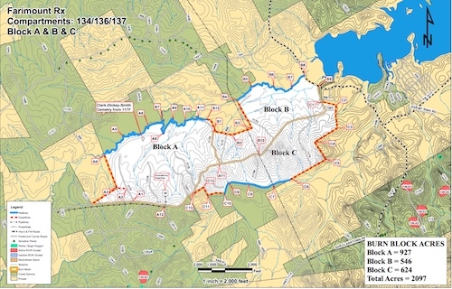
May 11, 2022 - Sabine N.F. – Compartments 134 (Fairmount RX) Block B & C only. Burn unit is located in the Fairmount Community, off State Highway 87, (Fox Hunters Hill) and Farm Market 3315. Burn Unit will be 1170 acres, with Helicopter Support and Winds are predicted from Southeast at 5-8 MPH.
May 10, 2022 - Officials with the National Forests and Grasslands in Texas, Sabine National Forests, have advised a prescribed burn today locations.
Sabine N.F. – Compartments 134 (Fairmount RX) Block A only. Burn unit is located in the Fairmount Community, off State Highway 87, and Farm Market 3315. Burn Unit will be 927 acres, with Helicopter Support and Winds are predicted from South at 6-10 MPH.
Please drive with caution. Also, we advised and long range drift SMOKE may affect some of the areas.
Pages


