

The story headline links to a better view of the story and share features.


News
Would-be Murderer and Child Rapist used the Dark Web to try Necrophilia and Cannibalism
September 17, 2020 - Beaumont, TX – A 23-year-old Joaquin, Texas man has been sentenced for child exploitation violations in the Eastern District of Texas, announced U.S. Attorney Stephen J. Cox today.
Alexander Nathan Barter pleaded guilty on Dec. 20, 2019, to attempted coercion and enticement of a minor and distribution of child pornography and was sentenced to 480 months in federal prison today by U.S. District Judge Michael Truncale. Following the completion of his prison sentence, Barter was also ordered to submit to a lifetime of supervised release.
As part of his plea agreement with the government, Barter agreed to be sentenced to a term of imprisonment of 20 years on each count, with each party reserving the right to request that the terms be sentenced concurrently or consecutively. Barter’s counsel requested that the Court impose a total term of imprisonment of 20 years; the government requested a sentence of 40 years’ imprisonment.
According to information introduced as part of Barter’s plea and at sentencing, in October 2018, Barter posted an ad on a dark web site stating, “I’d like to try necrophilia and cannibalism, and see how it feels to take a life. If you’d be willing to let me kill you, are in the US (preferably in the south) and can travel by car, contact me.” An undercover officer saw the ad and responded, utilizing the persona of a father with a 13-year old daughter. Between October 9, 2018 and October 19, 2018, Barter and the undercover officer exchanged a series of messages that included Barter’s repeated interest in raping, killing, and eating the 13-year old child. Barter provided the undercover with instructions on traveling from Florida to Shelby County, Texas, what to tell the child to get her acquiescence to travel, and how to conceal evidence of their crime. On October 19, 2018, Barter arrived at the designated meet site in Joaquin, Texas with a knife, trash bag, cellular phone, and a tablet.
“As this chilling case demonstrates, online talk is not always just talk. The constant vigilance of our law enforcement partners has prevented an evildoer from finding a likeminded accomplice and bringing his grisly plan to fruition,” said U.S. Attorney Stephen J. Cox. “This case is a sobering reminder of how the brave men and women of law enforcement face down the worst of the worst in the scariest of scenarios.”
“In my 23-year-career in law enforcement, this is among the most morally depraved and appalling criminal conspiracies that I have come across,” said Mark Dawson, special agent in charge of HSI Houston. “Without the quick and decisive actions of special agents from HSI Cocoa Beach and HSI Beaumont this disturbed predator would still be out there looking for potential victims to carry out his sick and demented fantasies.”
This case was brought as part of Project Safe Childhood, a nationwide initiative launched in May 2006 by the Department of Justice to combat the growing epidemic of child sexual exploitation and abuse. Led by U.S. Attorneys’ Offices and the Child Exploitation and Obscenity Section (CEOS), Project Safe Childhood marshals federal, state and local resources to better locate, apprehend and prosecute individuals who exploit children via the Internet, as well as to identify and rescue victims. For more information about Project Safe Childhood, please visit www.justice.gov/psc.
This case is being investigated by Homeland Security Investigations in Lufkin, Beaumont, and Houston, Texas; Homeland Security Investigations Cocoa Beach, Florida, Child Exploitation Task Force; Brevard County Sheriff’s Office (Florida); Nacogdoches Police Department; Texas Department of Public Safety; Customs and Border Protection Air Units; and Shelby County Sheriff’s Office, and prosecuted by Assistant U.S. Attorney Marisa Miller and U.S. Department of Justice Senior Trial Attorney Jennifer Toritto Leonardo.
Related Articles (Oldest to newest)
September 17, 2020 - With the flip of a (digital) switch Wednesday, Deep East Texas became the second region in the state to complete the conversion to Next Generation 9-1-1 technology. After months of planning and preparation, the Deep East Texas Council of Governments, which administers the Emergency 9-1-1 Network for the 12-county region, announced that “NG9-1-1” call routing is now live throughout the region.
This new system routes calls to 9-1-1 dispatchers using geospatial routing, which allows calls to arrive faster and provides more accurate location information of those making calls to 9-1-1. DETCOG Regional 9-1-1 Director Van Bush also noted the changes make DETCOG’s 9-1-1 system technology-proof and will allow further improvements to 9-1-1 services in the area over time. Call transfers between agencies will also be smoother.
“The old legacy 9-1-1 network was designed to accept calls from plain copper wire phones,” Bush said. “We’ve had to make adjustments over the years to take care of wireless, voice over internet protocol (VOIP), and text messaging. The NG9-1-1 system is an all IP environment where those services are easier to handle, and other new services can be easily brought onboard in the future.”
When a person in Deep East Texas encounters an emergency and dials 9-1-1, the call goes to one of 16 Public Safety Answering Points (PSAPs) around the region. There is at least one PSAP in each county, and all now employ the new technology. DETCOG was designated as a “beta” Council of Governments to deploy NG9-1-1 early and document lessons learned, which will aid in the transition of other regional 9-1-1 networks in Texas.
“We’ve been talking about the need to move to a Next Generation 9-1-1 environment for years,” Bush said. “There had to be a lot of planning and work to make this happen, not just us, but the county GIS coordinators in each county. It took thousands of hours of work put in to get the data quality we need for NG9-1-1 call routing.”
“And it certainly could not have been done without the support of the Commission on State Emergency Communications (CSEC) which is the state’s authority on emergency communications. CSEC is charged with administering the State 9-1-1 Service Program and is a valued partner. All of the funding for our program comes through them.”
The improvements were made using network infrastructure provided by AT&T’s Emergency Services IP Network (ESInet), which Bush touted as the backbone of DETCOG’s NG 9-1-1 network.
“The Commission on State Emergency Communications congratulations the DETCOG 9-1-1 regional program for its leadership in the state program’s transition to Next Generation 9-1-1,” said CSEC Executive Director Kelli Merriweather. “This transition will ensure that DETCOG continues to provide the excellent service it always has to its citizens both now and in the future as technology continues its rapid change.”
For the general public, little should change initially. The calls will simply go through more swiftly and locations will be more accurate, especially for wireless callers. For operators, the system comes with backend improvements and flexibility for the future.
DETCOG Executive Director Lonnie Hunt noted, “At the end of the day it’s all about public safety. The 9-1-1 network is a tool that connects citizens in an emergency to first responders. This enhancement will help save lives and better equip the responders. The old system served us for 50 plus years but was not designed for today’s digital world. NG9-1-1 makes things better now, but even more importantly it opens the door for new services and features that will be coming in the future.”
“It makes me proud to know we are leading the way,” Hunt added. I believe there are currently 24 PSAPs in the Texas CSEC program that have converted to NG9-1-1 and 16 of those are here in Deep East Texas. Van Bush and his staff, along with our county GIS coordinators, CSEC, and AT&T have all done a tremendous job getting this in place.”
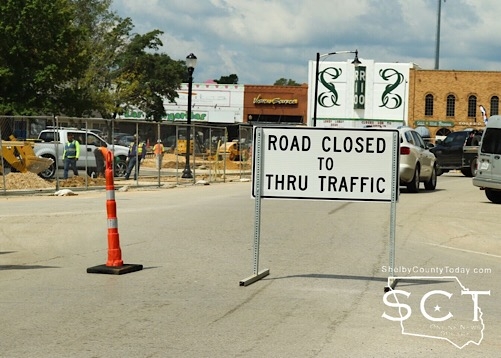
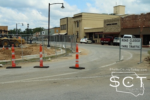
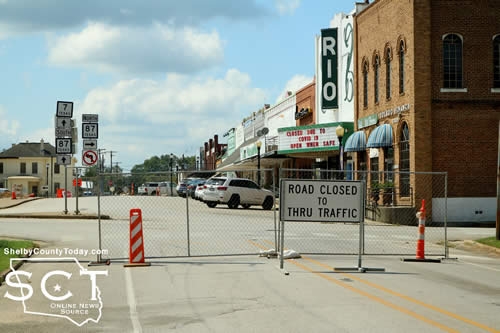
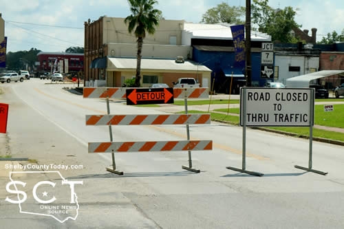
September 16, 2020 - The intersection of San Augustine and Shelbyville Streets in Center has now been blocked by construction crews working on the Center square.
In addition, Logansport Street is closed at the intersection of Porter Street toward the square. Tenaha Street is also closed at the intersection of Church Street leading to Nacogdoches Street.
Nacogdoches Street remains closed to through traffic in front of East Texas Awards and Engraving. The other side in front of Primp Salon leading to Nacogdoches and Austin Streets is open.
Many driver’s approaching the intersection from all directions are confused and having to redirect due to the unexpected closures.
Travelers should consider alternate routes when possible and use caution
On another note, the intersection of Nacogdoches and Austin Streets is once again open to the flow of traffic.


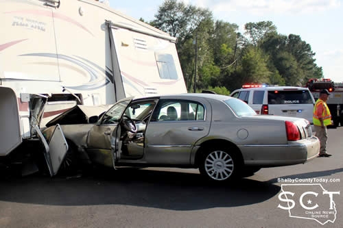
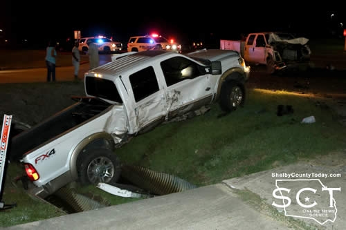
September 14, 2020 - Loop 500 at Martin Luther King Drive in Center was the scene of a major two-vehicle collision Monday, September 14, 2020 at around 5:15pm between a passenger car and an RV trailer.
Center Police Department confirms Quinnon Gardner, 41, of Center was the driver of a gold 2005 Lincoln Town Car which was traveling from Martin Luther King Drive and onto Loop 500 where it collided with the side of a Keystone Alpine 5th wheel being pulled by a grey Ford F350 4x4 pickup truck.
The driver of the truck appeared to have been unharmed, and Gardner was transported by ambulance to Nacogdoches Medical Center - Shelby Emergency Department for treatment.
Additional information will be added to this article when it's made available.
Construction work has been ongoing on Loop 500 and pilot vehicles kept traffic moving while Center Fire Department personnel diverted traffic around the crash scene.


September 14, 2020 - The Shelby County Emergency Management office reported Tuesday, September 8, 2020 its last COVID-19 report which included a cumulative case count of 442 for Shelby County.
According to Kerri Shofner, Emergency Management Coordinator, "After a lengthy discussion with DSHS this morning, we have decided that at this point the COVID numbers for Shelby County should be reported using the DSHS dashboard as opposed to the numbers reported to us that we’ve been providing."
The change in reporting is due to the fact Texas Department of State Health Services (DSHS) has stopped reporting deaths directly to the local officials and the numbers on the Texas COVID-19 dashboard are more quickly reported.
As of Sunday, September 13, 2020, the DSHS dashboard reports 455 cumulative cases, 418 recoveries, and 21 deaths for Shelby County.
No available breakdown of cases by zip code is available.
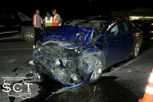
September 13, 2020 - U.S. Highway 84 East (Haslam Strip) in Joaquin was the scene of a major two-vehicle crash incident Friday, September 11, 2020.
When emergency responders arrived at the location, both vehicles remained in the middle of the roadway. Joaquin Volunteer Fire Department fire personnel began diverting traffic around the crash scene while also assisting with those involved in the crash.
According to Texas Department of Public Safety State Trooper Keith Jones, at 9:01pm a black 2005 Chevrolet Avalanche driven by David Charles Nunes, of Joaquin, was exiting a private driveway onto U.S. 84, turning left.
Nunes failed to yield right of way to a 2015 Chrysler 200 driven by Alexis Rajae Carter, of Logansport, that was traveling westbound on US 84 and subsequently struck the Avalanche.
Carter was transported by ambulance to Nacogdoches Medical Center - Shelby Emergency Department for treatment of minor injuries.
Nunes was issued a citation for fail to yield right of way approaching traffic turning left. Carter was issued a citation for fail to present proof of insurance.
Trooper Jones was assisted at the scene by Texas Department of Public Safety State Trooper Jesse Fountain and Constable Roy Cheatwood.
September 9, 2020 - The Shelby County Commissioners chose to abandon a portion of CR 2020 and to lease a location for the Justice of the Peace and Constable for Precinct 5 during their meeting held September 9, 2020.
Discussions have been ongoing at previous meetings over CR 2020, and many instances of trash being dumped along the road. The most horrific circumstances were that of the body of a man being burned and dumped on the roadway.
Roscoe McSwain, Precinct 1 Commissioner, wanted to make clear the property owners on either side of the roadway that is being closed are Hawkeye Hunting Club and East Texas Asphalt. Jimmy Lout, Commissioner Precinct 2, remarked a small portion of Tammy Warren's property touches the road, but she has access on another road.
Once the portion of the road is abandoned, dead end signs will be placed at either end to prevent people driving through the area. McSwain stated it will be up to the property owners to close the roadway with fencing.
Although the commissioners moved in a previous meeting to close 6 tenths of a mile, a motion carried to abandon one mile of CR 2020.
"It'll be full of garbage before long anyway. We've been moving it everytime we have to go through there" said Lout. "We've done hauled off eight or 10 bobtail loads of garbage over the years; they just keep dumping it out."
McSwain stated the road has been heavily used for drug traffic.
"By people from San Augustine and other places, that's where they found that dead body burned not long ago and it's been a trash problem for years," said McSwain.
He elaborated there are a lot of roads that might have trash problems in the county, and notably County Road 1000 near the baseball park, which he says has stopped.
"We don't need to get into a situation where there's individuals everywhere that's got problems with the road and start running to abandon the road or close it, because if the road needs abandonment or closed the commissioner should have foresight to see that and have that as his own idea," said McSwain. "We don't need the public telling us to start closing roads everytime, because there's going to be a lot of hard feelings."
The commissioners discussed the lease of a building on Austin Street directly across from the Timpson Public Library for the use of Tracy Broadway, Justice of the Peace Precinct 5, and Josh Tipton, Constable-Elect for Precinct 5.
When Judge Mike Crouch took office as Justice of the Peace for Precinct 5 in 2015, the office of the Justice of the Peace was moved to the former library location on Bremond Street.
March 9, 2015 the commissioners met and the contract for that lease was reviewed by County Attorney Gary Rholes and it was determined the lease was not a benefit to the county. At that time, in relation to the contract, the idea began for the county to purchase a structure and the City of Timpson had offered to provide the property for it to sit on at no cost. By March 27, 2015 the commissioners decided to purchase the building.
The new plan is for the Justice of the Peace to move out of the current structure and it will then be moved to the courthouse where it can be utilized by the treasurer, auditor and county judge for storage. Judge Harbison also plans on the porch currently attached to the structure to move.
"The only thing is we're not going to be able to rent it until October 1, but they're needing a deposit to hold it," said Judge Harbison. "So they're asking that we do a security deposit of $650 on it."
Judge Harbison suggested to Blackwell, the funds for the deposit could be taken from the current year budget of the Justice of the Peace and the Constable equally because the owner of the building has someone else interested in the space.
"I am going to go ahead and let the JP go ahead and start moving over there on October as well as the constable if he wants to," said Judge Harbison.
A motion carried to approve the lease agreement and approve the security deposit for the new Justice of the Peace and Constable location.
Rholes confirmed with Judge Harbison the new lease space is replacing the building the Broadway is currently using and Judge Harbison explained why.
"It's not large enough for a constable. Whenever we purchased that building and put it over there the constable was working out of the city PD office," said Judge Harbison. "The one that's coming in office in January, they would like to have an office together."
Judge Harbison said the new office location would be large enough to hold court and provide an office for the Justice of the Peace and constable.
"The city I believe is going to put in a handicap entrance to be able to get up onto the sidewalk," said Judge Harbison.
Judge Harbison opened and presented to the commissioners a bid from DGJD Inc. for delivery and installation of a 10 row, 106 foot long elevated bleacher seating for 700 people, with aluminum steps and seats, aluminum foot planks, materials delivered and installed for $54,400. Owner, Shelby County, will provide a level compacted pad for the bleachers.
A motion carried by the commissioners to accept the bid of $54,400 from DGJD Inc.
Judge Harbison presented a bid from ThyssenKrupp for a savaria lift elevator in the amount of $44,170, which is less than was expected.
"It is going to be kind of an open lift, with the gates and a cage and everything," said Judge Harbison.
Charles Barr, Precinct 3 Commissioner, and Commissioner McSwain said they have considered other possibilities, including renting space for the District Attorney's office, and one option for rent would cost a minimum of $36,000 for rent according to McSwain.
They also stated the annex building isn't up to code, and never has been.
"If somebody's handicapped, they have to meet them outside, a handicapped person can't go up to the DA's office," said McSwain.
A motion carried to approve the bid from ThyssenKrupp in the amount of $44,170 for the Annex Building, contingent upon Gary Rholes inspection of the contracts.
The meeting was adjourned at 10:12am.
Agenda items approved during the meeting include:

1. Minutes of the August 5, 2020 Special Meeting, August 12, 2020 Regular Meeting, August 19, 2020 Special Meeting, August 26, 2020 Special Meeting, August 26, 2020 Public Hearing, August 26, 2020 Special Meeting of the Shelby County Commissioner’s Court.

2. Pay weekly expenses.

3. Abandon a portion of CR 2020.

4. Office Lease for JP/Constable #5 and authorize a security deposit for said lease.

5. Award bid of $54,400 from DGJD Inc. for bleachers.

6. Award bid for elevator to be installed in the Courthouse Annex to ThyssenKrupp in the amount of $44,170.

7. Adjourn.
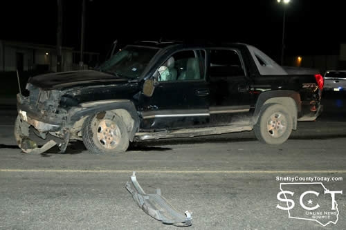
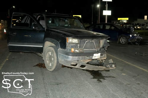
September 9, 2020 - Hurst Street at the intersection of Foster Street was once again the scene of a major two-vehicle collision early Monday, September 9, 2020.
One vehicle remained in the roadway, while another was in a deep drainage ditch when emergency personnel arrived.
According to Center Police Officer Angela Neal, at 5:14am a white 2012 Ford Super Duty F-250 driven by Brittany Campbell, 30, of Center crossed Hurst Street from the Walmart parking lot driveway attempting to reach Foster Street.

At that time a white 2015 Ford Super Duty F-350 driven by Bobby Hill, 64, of Center was northbound on Hurst Street when the F-250 crossed in his path causing the F-350 to strike the F-250 on the passenger side, causing major damage.
The F-250 spun around and came to rest in a ditch and the F-350 came to rest in the outside traffic lane of Hurst Street.
Hill's passenger Jesus Preza, 53, of Center was transported by ambulance to Nacogdoches Medical Center- Shelby Emergency Department for treatment of possible injuries. Campbell was taken to the hospital by private vehicle.

No citations were issued at the time of the crash. The Center Fire Department responded to the scene and assisted by diverted traffic around the crash scene.
As of this report, 20 crashes of varying severity have been reported to the State of Texas to have occurred at this location in the past five years.

September 8, 2020 - The Timpson square Tuesday, September 8, 2020 was the scene where two men allegedly began shooting at one another in front of a beauty salon, as reported by law enforcement.
One of the men received a gunshot wound in the arm, following which he made his way by vehicle to the other side of the square and across the railroad tracks to the Timpson Police Department where he found Timpson's only police officer, Chief Kent Graham.

According to Chief Graham, at around 3:50pm, Kody Newman received a bullet wound to the forearm, which was later determined to be non-life threatening.
The suspect Jimmy Drew Harris, 56, was taken into custody by Shelby County Sheriff's Deputies and Precinct 4 Constable Taylor Fanguy, 30 minutes following the incident.
The Shelby County Sheriff's Department confirms Harris has been charges with aggravated assault with a deadly weapon, felony 2; and deadly conduct, felony 3.
Newman was taken to a hospital for treatment of his injury.
The investigation into the incident remains ongoing.


September 8, 2020 - (Update) - In regards to the suspicious death that occurred Thurs., Sept. 4 on CR 3754 in Center, the deceased hs been identified as Kristy Simmonds of Center.
No further information is available at this time.
September 4, 2020 - The Shelby County Sheriff’s Office (SCSO) is actively investigating a suspicious death that occurred Thursday, Sept. 3, 2020 on County Road 3754 in Center. Upon arrival at the residence, officers spoke with an 88-year-old male who had been assaulted. Officers were advised that the subject was still inside the residence. Upon entry, officers found the body of a white female who was deceased in a back room of the residence. The body of the female subject was sent to Tyler for an autopsy.
If anyone has any information related to this incident, you are urged to contact Chief Deputy Kevin Windham at 936.598.5601.
Leah Chase, SCSO Media Relations
Pages