

The story headline links to a better view of the story and share features.


News
Stay alert for signal outages and flooding
August 26, 2020 - TxDOT is reminding the public to stay alert to traffic signals that may not work in the case of power outages and possible flooded roadways during Hurricane Laura.
Traffic signals that are not working due to electrical power outages should be treated as a four-way stop intersection.
“It is likely with possible power outages that motorists could encounter signal lights that are not operating,” said Rhonda Oaks, public information officer. “Motorists must stop at the intersection before proceeding. A blacked-out traffic signal is the same as a four-way stop.”
Motorists should also stay alert for flooded roadways and never drive through flooded areas. If barricades are set, do not attempt to drive around them.
Drivers should remain alert beginning tonight through tomorrow. Power outages and downed trees could cause some roadways to be blocked. TxDOT crews will respond and clear the roadways as soon as it is safe to do so.
“We are currently working 12-hour shifts and will continue this work schedule until the roadways are clear and open,” said Oaks. “We encourage people to stay off the road, if possible. Once the storm passes and motorists begin to move about, we urge them to stay alert for TxDOT and emergency workers responding to this emergency. Give them room to work and slow down.”
Visit drivetexas.org for statewide road closures. Follow the Lufkin District alerts on Twitter at TxDOT Lufkin. For more information, contact Rhonda.Oaks@txdot.gov or call (936) 633-4395.
August 26, 2020 - Whereas, the County of Shelby, Texas, on the 26th of August, 2020, is in imminent threat of being in the path of Hurricane Laura as described in reports by the United States National Weather Service and the Texas State Operations Center, potentially causing widespread injury or loss of life and severe property damage resulting from conditions created by torrential rainfall, major flooding with high speed winds and tornadic activity over an excessive period of time in residential, agricultural and commercial areas, as well as, major infrastructure damage preventing access to, or the safe passage on many roadways, as well as, the potential for long term countywide electrical power and utility outages. Such conditions will create an imminent public safety hazard.
WHEREAS, the County Judge of Shelby County, Texas, has determined, based upon trajectory reports issued by the National Weather Service and the Texas State Operations Center, that extraordinary measures be taken to protect life, as well as, to protect and/or rehabilitate property, and are necessary and hereby ordered.
NOW, THEREFORE, BE IT PROCLAIMED BY THE COUNTY JUDGE OF SHELBY COUNTY:
I. That a local state of disaster is hereby declared for Shelby County, Texas, pursuant to Section 418.108(0) of the Texas Government Code.
II. Pursuant to Section 418.108(b) of the Texas Government Code, the state of disaster shall continue for a period of not more than seven days from the date of this declaration unless continued or renewed by the Commissioners' Court of Shelby County, Texas.
III. Pursuant to Section 415.108(c) of the Texas Government Code, this declaration of a local disaster shall be given prompt and general publicity and shall be filed promptly with the County Clerk.
IV. Pursuant to Section 418.108(d) of the Texas Government Code, this declaration of a local state of disaster activates the county/city Emergency Management Plan.
Ordered this 26th day of August, 2020.
August 26, 2020 - The Shelby County Commissioners approved for the County Auditor to conduct an audit of the District Attorney Forfeiture/Seizure funds during their meeting held Wednesday morning, August 26, 2020.
According to the Code of Criminal Procedure regarding the audit, "All law enforcement agencies and attorneys representing the state who receive proceeds or property under this chapter shall account for the seizure, forfeiture, receipt, and specific expenditure of all the proceeds and property in an audit, which is to be performed annually by the commissioners court or governing body of a municipality, as appropriate. The annual period of the audit for a law enforcement agency is the fiscal year of the appropriate county or municipality and the annual period for an attorney representing the state is the state fiscal year."
County Attorney Gary Rholes stated, "I hear they might try to get rid of that the next session, or require a conviction before you get the money, seizure money."
Ann Blackwell, County Treasurer, commented there is a lot of it, suggesting there is a lot of money currently held by the county subject to seizure.
"It needs to all be done per law, by code and it needs to be done timely too as far as I'm concerned," said County Judge Allison Harbison. "I don't know whether it is or not, but I'm just saying that we have a lot in there and I really think it should move a little bit faster than that."
She said she hopes everyone is doing what they are supposed to be doing lawfully.
A motion carried to approve the County Auditor to conduct audit of District Attorney Forfeiture/Seizure funds per code of criminal procedure 59.06(g)(1).
Agenda items approved during the meeting inlcude:

1. Pay weekly expenses.

2. County Auditor to conduct audit of District Attorney Forfeiture/Seizure funds per code of criminal procedure 59.06(g)(1)..

3. Adjourn.
August 26, 2020 - The Shelby County Emergency Management office reports as of 8:49am on Wednesday, August 26, 2020, TxDSHS has reported 1 new case and the cumulative case count is now 426. The death count is 14 for Shelby County. (The DSHS website dashboard shows 19 deaths for Shelby County as of Aug 25th.)
According to the state's algorithm to determine recoveries, there are no new recoveries reported and the total of recoveries is 383. The number of active cases is 29.
Breakdown of cumulative cases by zip code and ages:
Active Cases in each zip code: (Change in Data)
Center (75935) - 14 (1 new)
Joaquin (75954) - 6
Shelbyville (75973) - 2
Tenaha (75974) - 3
Timpson (75975) - 4
Cumulative Cases in each zip code:
Center (75935) - 282 (1 new)
Joaquin (75954) - 29
Shelbyville (75973) - 27
Tenaha (75974) - 50
Timpson (75975) - 38
Ages of Confirmed Cases:
Ages 1 to 20: 40 cases
Ages 21 to 40: 139 cases (1 new)
Ages 41 to 60: 128 cases, 4 deaths
Ages 61 to 80: 77 cases, 4 deaths
Ages 81 to 100: 35 cases, 6 deaths
Age unknown: 7 cases
August 26, 2020 - Hostess Brands, LLC (“Hostess Brands”) is expanding its voluntary recall of certain Hostess® Raspberry Zingers® because the product may develop mold prior to the best by date.
The products were sold to mass merchandisers, grocery stores, distributors, dollar and discount stores, and convenience stores throughout the United States.
Consumers who have purchased the affected product are urged to discontinue consumption and contact the place of purchase about returning them for a full refund.
This recall does not affect any other Hostess Brands products.
Consumers with questions may contact 1-800-483-7253 Monday through Friday from 8:30 am to 4:30 pm Central Time.
Hostess Brands, LLC is headquartered in Lenexa, Kansas and operates bakeries in Emporia, Kansas, Chicago, Illinois, Columbus, Georgia, Indianapolis, Indiana and through its Voortman Cookies Limited subsidiary, Burlington, Ontario.
August 25, 2020 - A Hurricane Warning means hurricane-force winds are expected somewhere within this area within the next 36 hours. Locations affected include [Shelby County].
Wind - Latest local forecast: Equivalent Strong Tropical Storm force wind. Peak Wind Forecast: 45-60 mph with gusts to 85 mph. Window for Tropical Storm force winds: Wednesday evening until Thursday afternoon.
Threat to life and property that includes typical forecast uncertainty in track, size and intensity. Potential for wind 74 to 110 mph. The wind threat has remained nearly steady from the previous assessment.
Plan: Plan for life-threatening wind of equivalent CAT 1 or 2 hurricane force.
Prepare: Remaining efforts to protect life and property should be urgently completed. Prepare for considerable wind damage.
Act: Move to safe shelter before the wind becomes hazardous.
Potential impacts: Extensive. Considerable roof damage to sturdy buildings, with some having window, door, and garage door failures leading to structural damage. Mobile homes severely damaged, with some destroyed. Damage accentuated by airborne projectiles. Locations may be uninhabitable for weeks. Many large trees snapped or uprooted along with fences and roadway signs blown over. Some roads impassable from large debris, and more within urban or heavily wooded places. Several bridges, causeways, and access routes impassable. Large areas with power and communications outages.
Flooding rain: Latest local forecast: Flash Flood Watch is in effect.
Peak Rainfall Amounts: Additional 3-6 inches, with locally higher amounts.
Threat to life and property that includes typical forecast uncertainty in track, size and intensity:
Potential for major flooding rain: The flooding rain threat has remained nearly steady from the previous assessment.
Plan: Emergency plans should include the potential for major flooding from heavy rain. Evacuations and rescues are likely.
Prepare: Strongly consider protective actions, especially
if you are in an area vulnerable to flooding.
Act: Heed any flood watches and warnings. Failure to take action will likely result in serious injury or loss of life.
Potential impacts: Extensive- Major rainfall flooding may prompt many evacuations and rescues.
Rivers and tributaries may rapidly overflow their banks in multiple places. Small streams, creeks, canals, arroyos, and ditches may become dangerous rivers. In mountain areas, destructive runoff may run quickly down valleys while increasing susceptibility to rockslides and mudslides.
Flood control systems and barriers may become stressed. Flood waters can enter many structures within multiple communities, some structures becoming uninhabitable or washed away. Many places where flood waters may cover escape routes. Streets and parking lots become rivers of moving water with underpasses submerged. Driving conditions become dangerous. Many road and bridge closures with some weakened or washed out.
Tornado: Latest local forecast: Situation is somewhat favorable for tornadoes
Threat to life and property that includes typical forecast uncertainty in track, size and intensity: Potential for a few tornadoes
The tornado threat has remained nearly steady from the previous assessment.
Plan: Emergency plans should include the potential for a few tornadoes.
Prepare: If your shelter is particularly vulnerable to tornadoes, prepare to relocate to safe shelter before hazardous weather arrives.
Act: If a tornado warning is issued, be ready to shelter quickly.
Potential impacts: Limited
The occurrence of isolated tornadoes can hinder the execution of emergency plans during tropical events. A few places may experience tornado damage, along with power and communications disruptions. Locations could realize roofs peeled off buildings, chimneys toppled, mobile homes pushed off foundations or overturned, large tree tops and branches snapped off, shallow-rooted trees knocked over, moving vehicles blown off roads, and small boats pulled from moorings.
For more information: http://ready.gov/hurricanes
August 25, 2020 - Shelby County is among the list of 36 newly added counties to the State's Disaster Declaration concerning Hurricane Laura on Tuesday, August 25 due to the threat of severe rain, wind, and flooding.
Shelby County Attorney Gary Rholes would like to remind everyone that price gouging in a disaster area is a crime. If anyone suspects price gauging, please contact the Shelby County Attorney's office at 936-598-6100 and it will be investigated.
August 25, 2020 - Governor Greg Abbott today held a press conference at the Alternate State Operations Center in Austin where he provided an update on the state's response to Hurricane Laura. This hurricane is expected to impact the Texas Coast and Southeast Texas as early as Wednesday and bring heavy rainfall, flooding, high winds, and storm surge. The Governor also received a briefing from the Texas Division of Emergency Management (TDEM), which included an update on response and preparedness efforts from state agency directors and the Federal Emergency Management Agency (FEMA). Additionally, the Governor announced that he has added 36 counties to his State Disaster Declaration due to the threat of severe rain, wind, and flooding.
During the press conference, Governor Abbott discussed the threat of high winds as well as life-threatening storm surge where Hurricane Laura makes landfall. The Governor also discussed evacuation efforts throughout the state, and announced that reception centers in San Antonio, Dallas-Fort Worth, and Austin will open later today. The state is providing buses to transport Texans that are evacuating. There are also over 225,000 hotel rooms available across the state to provide shelter to evacuees. A full list of mandatory and voluntary evacuations can be found on the Texas Hurricane Center web page. Governor Abbott urged Texans to take action now to protect themselves and their property.
"Hurricane Laura is rapidly intensifying and poses a major threat to communities in Southeast Texas and along the coast," said Governor Abbott. "Texans in the path of this storm should waste no time preparing for the impact of Hurricane Laura and take immediate action to keep themselves and their loved ones safe. I urge our Southeast and Coastal communities to heed the guidance of local officials, follow evacuation orders, and remain vigilant as we brace for the impact of Hurricane Laura. The State of Texas will continue to monitor this storm and provide the resources needed to keep Texans safe."
Hurricane Laura was upgraded from a Tropical Storm earlier today. It is currently a Category 1 hurricane but is expected to gain strength to a Category 3 or 4 hurricane as it makes landfall over Southeast Texas and Southwest Louisiana late Wednesday or early Thursday. Beginning Wednesday, these areas will experience tropical storm force winds, heavy rain, significant storm surge, possible flash flooding, and rising water levels. The chances of hurricane force winds will increase Wednesday evening. Heavy rainfall that begins over Southeast Texas on Wednesday will shift into Northeast Texas on Thursday. The primary water threat will be from storm surge. Texans are urged to remain vigilant and aware as Hurricane Laura continues to head towards Texas.
Additional state resources have been rostered to help respond to Hurricane Laura. TDEM has activated the following resources and personnel:
- Texas A&M Forest Service: Incident management teams, chain saw crews, firefighting strike teams, and water evacuation and rescue teams
- Texas A&M Engineering Extension Service: Urban search and rescue teams and swift water rescue teams, including Texas A&M Task Force 1 and 2
- Texas A&M Agrilife: Agents positioned to support emergency operations centers and disaster finance teams
- Texas Military Department: High profile water rescue vehicles, airplanes and helicopters for evacuation and rescue, shelter management teams, evacuee tracking network teams, 6th Civilian Response Team available for Hazmat response
- Texas Department of Public Safety: Rescue helicopters, command and control airplanes, swift water rescue boat teams, flood response boat teams, dive boat teams, as well as Troopers, agents, and Rangers to assist local Law Enforcement with evacuation and securing evacuated areas
- Texas Parks and Wildlife: Game Wardens, State Park Police, swift water rescue boats, Shallow water evacuation boats, air boats, incident management teams, and a helicopter rescue team
- Texas Department of State Health Services: Emergency Medical Task Force (EMTF) Ambuses, EMTF ambulances, EMTF Medical incident management and support teams
- Texas Department of Transportation: High profile water rescue vehicles, traffic control devices, and flood protection barriers
- Texas Commission on Environmental Quality: Water and waste water monitoring teams and hazmat response teams
The Texas Health and Human Services Commission and the Public Utility Commission are also assisting in response efforts. For more information on the state's response to Hurricane Laura, as well as resources for those impacted by the storm, visit the Texas Hurricane Center.
Reception Centers for Evacuees:
San Antonio (Opening at 3:00 PM CT today)
254 Gembler Road
San Antonio, TX 78219
Austin (Opening at 4:00 PM today)
Circuit of the Americas
9201 Circuit of the Americas Boulevard
Austin, TX 78617
Dallas-Fort Worth (Opening at 7:00 PM today)
Mesquite Reception Center
15515 E. IH-20
Mesquite, TX 75181
Ellis County (Opening at 7:00 PM today)
Knights of Columbus Hall
850 S IH-45
Ennis, Texas 75119
View the Governor's proclamation adding more counties to his State Disaster Declaration.
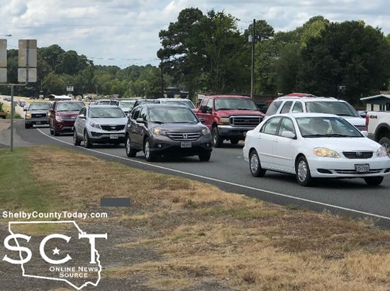
August 25, 2020 - Highway 96 North is heavy with traffic as evacuees are making their way north to avoid Hurricane Laura. Be alert to traffic delays especially if trying to cross over US 96.

August 25, 2020 - The Shelby County Emergency Management office reports as of 9:18am on Tuesday, August 25, 2020, TxDSHS has reported 2 new cases and the cumulative case count is now 425. The death count is 14 for Shelby County. (The DSHS website dashboard shows 19 deaths for Shelby County as of Aug 25th.)
According to the state's algorithm to determine recoveries, there are 6 new recoveries reported and the total of recoveries is 383. The number of active cases is 28.
Breakdown of cumulative cases by zip code and ages:
Active Cases in each zip code: (Change in Data)
Center (75935) - 13 (1 new, 3 recoveries)
Joaquin (75954) - 6 (1 recovery)
Shelbyville (75973) - 2 (1 recovery)
Tenaha (75974) - 3
Timpson (75975) - 4 (1 new, 1 recovery)
Cumulative Cases in each zip code:
Center (75935) - 281 (1 new)
Joaquin (75954) - 29
Shelbyville (75973) - 27
Tenaha (75974) - 50
Timpson (75975) - 38 (1 new)
Ages of Confirmed Cases:
Ages 1 to 20: 40 cases
Ages 21 to 40: 138 cases (1 new)
Ages 41 to 60: 128 cases, 4 deaths
Ages 61 to 80: 77 cases (1 new), 4 deaths
Ages 81 to 100: 35 cases, 6 deaths
Age unknown: 7 cases
Pages