


June 3, 2024 (9:39pm) - At 9:39pm, severe thunderstorms were located along a line extending from near Waskom to near Deberry to 6 miles north of Joaquin to near Timpson, moving east at 50 mph.
June 3, 2024 (9:35pm) - Severe Thunderstorm Watch 385, previously in effect until 10pm this evening, is now in effect until Midnight tonight for the following areas.
- North Central Louisiana - Caldwell, Grant, Jackson, La Salle, Winn
- Northwest Louisiana - Bienville, Bossier, Caddo, De Soto, Natchitoches, Red River, Sabine and Webster
- Northeast Texas - Angelina, Cherokee, Harrison, Marion, Nacogdoches, Panola, Rusk, Sabine, San Augustine, and Shelby
June 3, 2024 (6:50pm) - At 6:50pm Monday, June 3, 2024, the National Weather Service Shreveport, LA advises Severe Thunderstorm watch 385 to include the following areas until 9pm this evening.
- North Central Louisiana - Caldwell, Grant, Jackson, La Salle, Ouachita, Winn
- Northwest Louisiana - Natchitoches and Sabine
- Northeast Texas - Angelina, Cherokee, Nacogdoches, Sabine, San Augustine, and Shelby
This includes the cities of Center, Clarks, Colfax, Columbia, Dry Prong, Grayson, Hemphill, Jacksonville, Jena, Jonesboro, Lufkin, Many, Midway, Monroe, Montgomery, Nacogdoches, Natchitoches, Olla, Pineland, Pleasant Hill, Rusk, San Augustine, Winfield, and Zwolle.
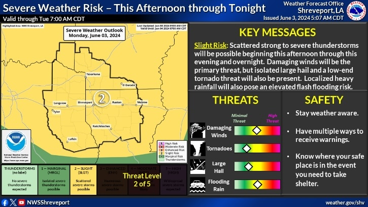
June 3, 2024 - The National Weather Service, Shreveport, LA issued at 2:57pm on Monday, June 3, 2024 a Hazardous Weather Outlook for north central Louisiana, northwest Louisiana, east Texas and northeast Texas.
Monday afternoon and tonight - A complex of thunderstorms is developing across Oklahoma and has approached the Four State area this afternoon and evening, some may be severe with damaging winds primarily. Overnight, we may see a second complex of thunderstorms arriving in southeast Oklahoma and southern Arkansas by daybreak. These thunderstorms have been progressive, but due to the widespread rains lately, flash flooding may accompany the lightning and gusty winds with some heavy downpours on our wet soils.
Tuesday through Sunday - Isolated to scattered showers and thunderstorms will persist to some extent during midweek. However, the coverage and intensity of thunderstorms should see a decrease each day through Thursday. Then, we can expect another weak cold front to arrive on Friday with more widespread thunderstorms affecting our area in this same night and or day pattern. The weekend now looks to see the front become stationary west of I-49, acting to focus areas of rainfall. Additional rivers and bayous will see rises and minor flooding continue into next week.
Spotter activation may be needed.