

The story headline links to a better view of the story and share features.


News
March 20, 2023 - Over the week of March 12th through 18th the Joaquin Volunteer Fire Department responded to a total of 5 calls. Here’s a summary of the week’s events.
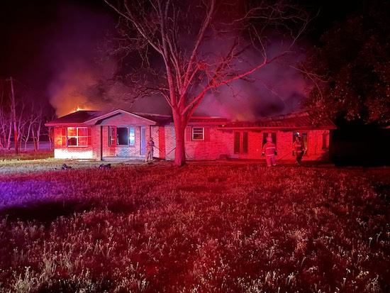
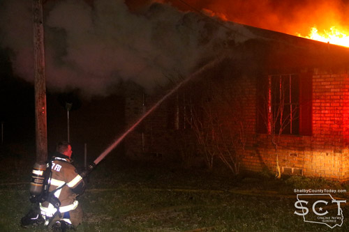
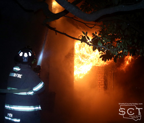
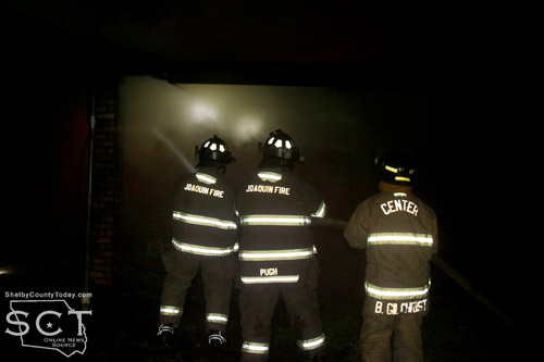
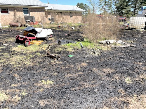
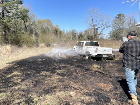
Early Sunday morning at 4:24am Center Fire Department requested assistance from the JVFD on a house fire on Highway 7 East. Upon arriving, the house was found to be fully involved with flames on the back side that were quickly spreading to the front rooms. The Joaquin VFD took 2 trucks with large capacity water tanks, both of which had to be refilled during the fight to get the fire under control. After a couple of hours of intense firefighting by both Center and Joaquin, the fire was able to be contained. The house was a complete loss, but was fortunately uninhabited.
Tuesday night at 8:51pm a call was received in regards to a large burn pile that may be spreading on County Road 3290. This was later discovered to be a control burn and showed no signs of potentially spreading any further.
Wednesday morning at 12:26am Allegiance EMS requested the JVFD’s help with a lift assist on a patient at a residence on Carroll Street.
Thursday afternoon at 3:02pm a call came in for a female possibly having a heart attack at a residence on Highway 7 East. The Joaquin VFD responded is association with Allegiance EMS to get the patient the help they needed.
Lastly on Saturday at 12:00pm a call was received for a person in respiratory distress at the Joaquin Apartments on Highway 84 East. The JVFD responded to provide assistance until Allegiance could arrive.
With that, this edition of the report will come to a close. The Joaquin Volunteer Fire Department hopes everyone has a great and safe week going forward.
Related article: Center Fire Department Fights Two House Fires on Sunday
March 17, 2023 - Center Fire Department personnel responded to two house fires on Sunday, March 12, 2023, with one in the county and the other within the Center city limits.
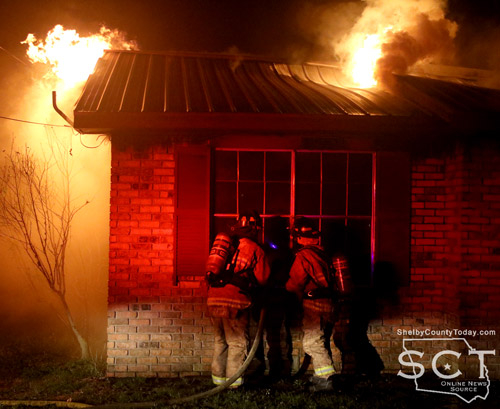
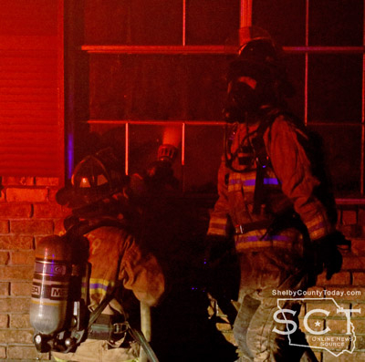
The first fire took place before dawn in the 3000 block of State Highway 7 East at 4:06am. According to the Center Fire Department, when fire personnel arrived at the house, the structure was well involved in fire and there was smoke throughout the house. Fire personnel entered the building and began performing a search for anyone inside the structure. Due to worsening conditions, the firefighters backed out of the building and due to the need of additional support called for assistance from the Joaquin Volunteer Fire Department, who responded with other units and provided additional water.
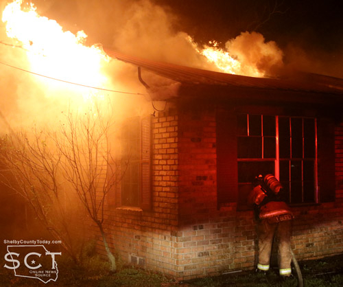
Indications are the fire started in the back of the structure; however, the cause is unknown. It was later confirmed the house was unoccupied. Fire personnel returned to the station at 8:31am.
Later that day at 4:43pm, fire personnel were dispatched to a structure fire in the 1300 block of Louisiana Street, and when they arrived arrived heavy smoke could be seen pushing from the attic space of a brick structure. Fire was showing through a window and door on the left side of the house, and entry was made into the home where the main body of the fire was knocked down at that time.
It was then discovered that fire had made its way into the attic space. Ventilation was made and final extinguishment was accomplished. Once it was determined all fire was clear, the fire department units returned to the station at 7pm.


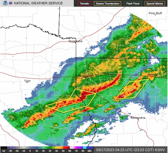
March 16, 2023 - The National Weather Service (NWS), Shreveport, LA, issued an updated Hazardous Weather Outlook at 11:14pm, Thursday, March 16, 2023.
Tornado Watch 69 in effect until 1am, Friday, March 17, 2023.
This Hazardous Weather Outlook is for southwest Arkansas, northwest Louisiana, east Texas and northeast Texas.
- Tonight - A line of strong to severe thunderstorms will continue to move across portions of Southwest Arkansas, East Texas, and Northwest Louisiana tonight. Damaging straight- line winds, large hail are the primary threats. A tornado or two cannot be completely ruled out. The severe weather threat should diminish during the early morning hours of Friday.
- Friday through Wednesday - Temperatures are expected to fall to near or below freezing Saturday and Sunday nights across portions of extreme Northeast Texas, Southwest Arkansas, and North Louisiana, as colder and drier air continues to spill south into the region this weekend. Precautions should be taken to protect tender vegetation from these cold temperatures.
At 11:07pm, the NWS in Shreveport issued a severe thunderstorm warning until 11:45pm for Southwestern De Soto Parish in northwestern Louisiana, Northwestern Sabine Parish in northwestern Louisiana, Southeastern Panola County in northeastern Texas, Northern Nacogdoches County in eastern Texas, Shelby County in eastern Texas, and Northern San Augustine County in eastern Texas.
At 11:06pm, severe thunderstorms were located along a line extending from 7 miles north of Logansport to near Center to near Nacogdoches, moving southeast at 35 mph. Radar indicated 60 mph wind gusts and penny size hail. Expect damage to roofs, siding, and trees.
A Tornado Watch remains in effect until 1:00am for eastern and northeastern Texas. A Tornado Watch also remains in effect until 5:00am for northwestern Louisiana.
For your protection move to an interior room on the lowest floor of a building.
Tornado Watch 69 remains valid until 1am Friday for the following areas:
- In Southwest Arkansas - Columbia, Lafayette, and Nevada
- In Northwest Louisiana - Bossier, Caddo, and Webster
- In Northeast Texas - Angelina, Cherokee, Nacogdoches, Panola, Rusk, San Augustine, and Shelby.
This includes the cities of Bossier City, Bradley, Carthage, Center, Henderson, Jacksonville, Lewisville, Lufkin, Magnolia, Minden, Nacogdoches, Prescott, Rusk, San Augustine, Shreveport, Springhill, and Stamps.
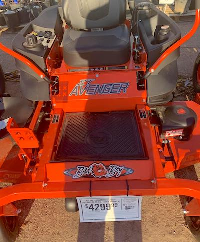
March 16, 2023 - On Tuesday, March 14, 2023, a Bad Boy Avenger Lawn Mower was stolen during the daytime hours from the Iglesia Fiesta Pentecostal Church located at 1318 Shelbyville Street. If you or anyone you know has any information regarding this theft please contact the Center PD at 936-598-2788 or the Church Pastor, Martin Soto at 936-572-2375.
March 15, 2023 - County Road 1520 will be closed starting tomorrow, March 16, from FM 138 to CR 1515
March 13, 2023 - The week of March 5th through 11th was an active one for the Joaquin Volunteer Fire Department with a grand total of 8 calls responded to. Here’s a summary of the week’s events.
On Sunday at 12:41pm a call was received for a grass fire spreading toward a home on County Road 3000. The homeowner was able to get much of the fire under control before the JVFD arrived, but the yard was still sprayed down again with a brush truck to prevent any flare ups.
Monday morning at 9:18am a call came in for a female having trouble breathing at a residence on County Road 3598. The EMR team responded in association with Allegiance EMS to help the patient.
On Tuesday two calls were received within minutes of each other, with the first being a male with chest pains on County Road 3822, and the second being the same patient from Monday on County Road 3598 with breathing trouble.
Wednesday morning at 6:23am a page was received regarding a man who was not breathing at a residence on Highway 84 East. It is unknown how long the man had not been breathing but, despite efforts made through CPR to restart his breathing, he was pronounced deceased at the scene.
Wednesday evening at 5:47pm a call came in for a man having a mental episode at a residence on Highway 7 East. The EMR team attempted to calm down the man, but he was later taken into the custody of the Shelby County Sheriff’s Office.
Thursday morning at 11:11am the EMR team was called to help Allegiance EMS with a lift assist on Carroll Street.
Lastly, on Friday night a page came in for an unresponsive male at the Joaquin Apartment’s on Highway 84 East. The JVFD medical team responded, as well as Allegiance EMS, to check out the patient. The scene was cleared once it was found that the patient’s vitals were good and they had regained their alertness.
With that, this edition of the report will come to a close. The Joaquin Volunteer Fire Department hopes everyone has a great and safe week ahead.

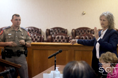
March 12, 2023 - Shelby County Commissioners decided March 1, 2023, to move forward in assisting the Texas Department of Public Safety by supplying the funds for the purchase of a device to access a vehicle Event Data Recorder (EDR).
District Attorney Karren Price and Texas Department of Public Safety State Trooper Taylor Buster presented the Shelby County Commissioners with a proposal for equipment necessary for crash investigations.
“Each of you in your precinct can remember a wreck or an incident where, had we been able to download the box on the vehicle quickly, we might have a different result at the end of the day,” said Price.
Price described two main ways data is extracted from the EDR via a Crash Data Retrieval (CDR) with the first being by consent of the driver, and the other being a search warrant issued by a District Judge. She assured the commissioners there wouldn’t need to be a worry about an officer just accessing the EDR on a whim, because that would be a civil rights violation of the fourth amendment resulting in federal charges.
“DPS doesn’t buy these pieces of equipment for their own staff to use,” said Price. “Counties have to buy it, DPS is in charge of it, they keep custody care and control of it at all times. No one else in the county is able to do that, no one else in the county is certified to do that, to use that equipment.”
The equipment would be assigned to Trooper Buster for him to use, because Price said he is the only one in the county that will be certified and be responsible to use the equipment. Price said the proposed purchase will cover every make of vehicle with the exception of Kia and Hyundai. She said Nacogdoches County is buying the equipment which will work with Kia and Hyundai which will put it in a neighboring county.
That way neither county will have to carry the entire financial burden and, when necessary, the troopers can share the equipment. There is an annual fee for updates of software to the CDR. Price explained to the commissioners they would not have to bid for the equipment since Bosch is the only manufacturer of the CDR.
Trooper Buster explained there are several variables involved in the information gathered by the CDR from different vehicles.
“Toyota’s more diverse, it’s going to have a lot more data that’s collected,” said Trooper Buster.
According to Trooper Buster, there is a national standard that all vehicles must meet, and although the EDR is very much like a “black box” which would be included in an airplane that would be a misnomer because it doesn’t collect the exact same data.
“It’s not recording voice, it’s not recording like a airplane would record your cockpit and everything else,” said Buster.
He elaborated that the EDR is recording things like vehicle speeds, and whether brakes activated or not.
“Toyota before, I believe it was 2012 on a Toyota they had limits, they didn’t record speeds higher than 78.8 miles an hour,” said Trooper Buster. “The newer vehicles are recording higher speeds than that. You have some that when you plug into it it’s going to tell you that they were going 120-130 miles an hour. Now to go into court with that, we’re still going to use the math, but that gives us a checking point to where when I run the numbers on the side of the road from a skid mark and I download that, I’ve got something to give the District Attorney or the County Attorney in that case to back up the charges that we’re using as more evidence.”
Price interjected there currently is a case where the equipment used for extraction of data was second generation, and the vehicle being investigated was first generation, and there was a .03 difference in the math between that which Trooper Buster performed and the math of the device.
“The problem with the case, the difficulty in the proof of the case the evidence is that 78.[8 mph] is the highest that we record,” said Price. “The speedometer broke at 84 [mph], so the question is gonna be what was he really doing when the speedometer broke?”
She further explained speedometers don’t necessarily break at the highest speed, or indicate the exact highest speed of the vehicle. Price stated the new equipment will catch all of that data accurately every time.
Price further explained the CDR will remove the doubt in both criminal and civil cases involving liability when the deciding factor may be .03% of one mile per hour.
Trooper Buster shared there have been times when they have needed access to a CDR, and before the equipment could make it to Shelby County for use, enough time would pass so that the vehicle in question may have been crushed and cease to be available.
“It will benefit us, because we will have one that we will be able to collect the data and the evidence from the side of the road, or there shortly after that crash has occurred to where we will be able to prove our case,” said Trooper Buster.
The quote for the purchase includes an annual fee of $1,500 for yearly updates to software, this also had what is called a TEDR kit which is specific to Tesla and has a one time download of software for Tesla as well as cables, adapters, power to perform in-vehicle and direct to module downloads on Tesla Model 3, Y, S and X vehicles.
“On the Tesla they have no subscription annually, there is no annual renewal fees on the Tesla. Tesla says, ‘here is all of our cables, here is our box to download the Teslas,” said Buster.
He remarked there are many Teslas on Shelby County roads even now. Trooper Buster said the county, citizens as a whole and the city of Center will benefit from the purchase of the equipment.
A motion carried by the commissioners to use the remainder of the Coronavirus Relief funds for part of the purchase and to take the rest out of the contingency fund. The total amount on the quote was $32,625.
The commissioners considered a Resolution clarifying the closure of two portions of County Road 2794, containing 0.427 acres and 0.151 acres in Precinct 2 and adopting a 0.627 acre tract designated as County Road 2706, this Resolution will correct the Resolution adopted January 12. 2022.
“Mr. [John] Price, [County Attorney], has worked tirelessly on this to get this straightened out, but we’re going to have a good deed to that road,” said Judge Harbison.
County Attorney Price explained the adoption of the resolution will clear up the description from the January 2022 meeting where the item was approved as far as acceptance of the new road, but it will also close out those portions of County Road 2794 which will be abandoned.
“I think Commissioner [Jimmy] Lout has seen the road, and I’ve seen pictures of the road, they did an awfully good job constructing that new road down there,” said Price.
A motion carried by the commissioners to approve the resolution to approve the permanent closure of two portions of County Road 2794.
Judge Harbison related that she and County Attorney Price met with the city of Center and their maintenance department to discuss installing a manhole and addressing a sewer issue at the jail by installing a sewer screen.
A motion carried to approve the change order for the project Whitaker Plumbing is working on from $150,000 to $162,000.
The meeting adjourned at 10:08am.
Agenda items approved during the meeting include:

1. Pay weekly expenses.
2. Current payroll.
3. Purchase EDR equipment for use by DPS.
4. Resolution clarifying the closure of two portions of County Road 2794, containing 0.427 acres and 0.151 acres in Precinct 2 and adopting a 0.627 acre tract designated as County Road 2706, this Resolution corrects the Resolution adopted January 12. 2022.
5. Change Order No. 1 to amend the "Shelby County Jail Emergency Repairs Agreement" with Whitaker Plumbing.
6. Adjourn at 10:08am.
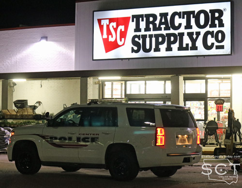
March 10, 2022 - Predator Poachers, a group of private citizens out of Houston, Texas, assisted in initiating the arrest of a Timpson man for soliciting a minor for sex at a local retail store in Center.
According to the Center Police Department, they were called to the Tractor Supply on Friday evening, March 3, 2023 and upon arrival located four individuals near the loading dock on the side of the store. The first officer on scene was notified immediately of an undercover operation by private citizens regarding a child predator who had solicited sex from a person the predator believed to be a 13-year-old female.
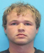 The Center Police Department began their investigation and James Alan Burke, 33 of Timpson, was arrested. At the time of the incident, he was an employee of the store. Burke was taken into custody without incident and charged with Online Solicitation of a Minor as well as four counts of Failure to Comply with Sex Offender Requirements. He is currently being held in the Shelby County Jail with a bond of $675,000 for the charge of Online Solicitation of a Minor and bonds of $100,000 on each of the four charges of Failure to Comply with Sex Offender Requirements for a total of $1,075,000 in bonds set by Donna Hughes, Justice of the Peace for Precinct 1.
The Center Police Department advised this is an ongoing investigation and no additional information is available at this time.
According to Texas Department of Public Safety records, Burke is a lifetime sex offender and his last reported verification on record was from July 21, 2022 with the Shelby County Sheriff’s Office. In 2013, Burke was convicted with sexual assault in the fourth degree in Arkansas where the victim was a 14-year-old female.
Predator Poachers makes online profiles of minor children and publishes them on different social media websites where a predator can message and solicit them for sex.
A video of the encounter with James Alan Burke was made and lasted over 1 hour starting from the moment the group walked into the store with a decoy until after the Center PD showed up on scene. At 4 minutes into the video, Burke is approached by the interviewer just as he is showing the girl the bathroom door.
The interviewer tells Burke he has everything saved from his correspondence with the 13-year-old showing him a stack of papers of the messages. He adds he just wants to talk to him. One of his first questions was “Why were you bringing her to the bathroom?” Burke replies, “I actually wasn’t going to do anything, I really wasn’t, I just was going to meet her.” He added, “I was wanting to meet her, she seemed cool.”
At 12 minutes, the interviewer is telling Burke he understands he is employed and a worker which is good and Burke adds, “Not to mention I’m ordained.” The interviewer replies, “Oh, you’re an ordained minister” and Burke answers, “Pagan minister, yeah.” As the conversation continues, the interviewer keeps working to get Burke to confirm the messages are his. Burke claimed some of the messages being presented were not him because his account had been hacked.
Burke confirms at just over 25 minutes that there were some requests for pictures but they were just getting carried away type of things. The interviewer asks point blank, “Did you ask for nudes?” and Burke grimaces as he nods saying, “But thankfully she declined.” He then turned to the girl decoy and says, “Thank you, by the way” and grins. The interviewer reiterated, “Ok, but you asked for…” and Burke repeats in a louder tone, “It was requested but thankfully she had a better mind.” Burke then looks at the girl decoy and asks her how old she is and she replies 26. Burke then adds, “They still would have been legal nudes. Thankfully.” The interviewer replies, “Well this isn’t, you weren’t talking to her, this is just somebody that looks like her. But honestly you were requesting pictures of who you thought was 13. So, you know.”
The interviewer pushed Burke more regarding exactly what pictures he requested and Burke just kept saying “thankfully nothing was sent and I’m really glad.” Burke gave the excuse of it was just getting carried away. The more the interviewer read out loud the requests Burke made of the 13-year-old, Burke covered his eyes saying, “Yes, yes, yes, I know, I’m not going to deny it. I just don’t want to be in trouble. I really don’t.” The interviewer offered some sympathy and suggested maybe it’s too much time on the internet. Burke replies that he is going to delete all his accounts. Their conversation continued regarding the different social media platforms and the number of underage users online pretending to be older.
After checking on something at work, Burke returns to talk. The interviewer continued addressing the messages between Burke and the 13-year-old. The messages from the night before their scheduled meeting were very graphic descriptions of things they could do. One of the least graphic messages from Burke the interviewer read aloud included, “I crave you. You want me to be your first.”
The interviewer got more direct saying this isn’t rookie stuff and I think you got carried away. Burke confessed in reference to the 13-year-old, “I was not going to force it… if she was willing, yeah.” The interviewer asked, “Was sex going to happen if she was willing,” and Burke covered his month and responded, “Most likely. If I didn’t back out, because, you know, the fear of getting caught.”
At 1 hour and 4 minutes, the Center Police Department showed up on scene. Burke quickly talks to the officers saying they are just talking about stuff in Fort Smith, Arkansas when the interviewer says, “He invited a 13-year-old girl to his work to have sex with her and has child porn that he’d received.” Burke said, “There weren’t no porn.” A camera person with the citizen group added, “He’s also a sex offender on the run.”
As the officer is talking to the interviewer, Burke can be heard saying repeatedly, “I’m going to jail. I’m going to jail.” When the officer is informed Burke has a warrant out of Fort Smith, Arkansas, Burke responds, “It is an in state pickup only.”

Bullet entry of victims vehicle
March 10, 2023 - Sheriff Kevin W. Windham reports the arrest of Michael Barbee, 56, of Nacogdoches.
 On March 9, 2023, at approximately 7:18 p.m., a call was received through the Telecommunications Center at the Shelby County Sheriff’s Office (SCSO) in reference to shots fired at the car wash near Timpson Quick Stop. Constable Precinct 5 Josh Tipton was first to arrive on scene and began gathering information from witnesses. Deputies arrived on scene, and learned that Barbee allegedly fired shots at two individuals, and that the gunfire struck an innocent bystander. The suspect and victim left the scene before deputies arrived, and SCSO investigators began searching for all involved parties.
At approximately 10pm, investigators located the shooting victim in Carthage, and interviewed him in reference to the incident. At approximately 11pm, investigators learned that the suspect was in Nacogdoches. Investigators contacted Nacogdoches Police Department (NPD), and NPD located the suspect at a gas station and detained him until SCSO investigators arrived. Once on scene, investigators arrested Barbee on three counts of Aggravated Assault with a Deadly Weapon. Barbee was transported back to Shelby County and booked into the Shelby County Jail where he is being held on bonds totaling $150,000 set by Donna Hughes, Justice of the Peace for Precinct 1.
The victim who sustained the gunshot wound was not critically injured.
The SCSO would like to thank Constable Precinct 5 Josh Tipton; Constable Precinct 4, Taylor Fanguy; Constable Precinct 2 Jamie Hagler; Constable Precinct 1 Zack Warr; Texas Department of Public Safety; Nacogdoches County Sheriff’s Office; Nacogdoches Police Department; and Carthage Police Department for their assistance with this situation.
Related article: Timpson Fuel Station Scene of Reported Multiple Gunshots (Updated)
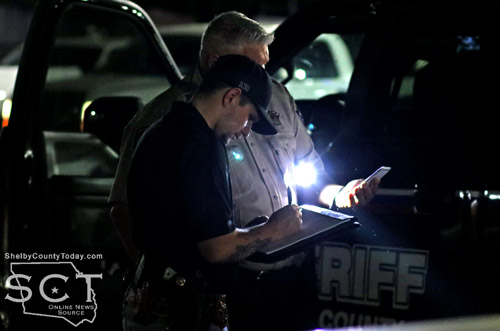
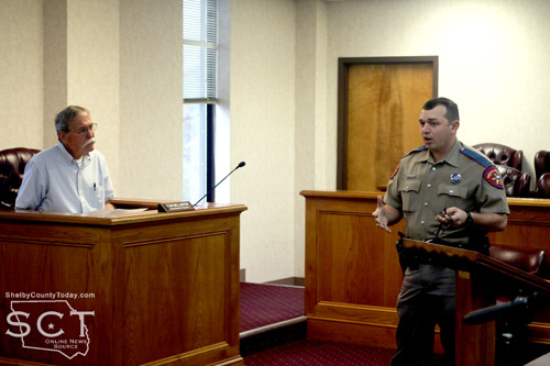
Shelby County Sheriff's Investigator Aaron Jones is seen going over details with Sheriff's Deputy Cody Muse.
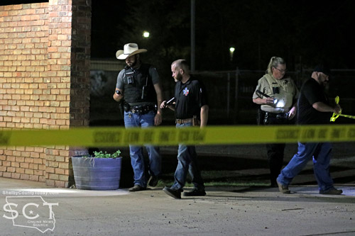
March 9, 2023 - Emergency personnel responded to the Timpson Quick Stop when multiple gun shots were reported from the area of the business’s car wash Thursday, March 9, 2023, around 7:18pm.
When law enforcement officials arrived at the scene of the incident, the suspect and potential victim had each fled the scene. The area of the car wash was cordoned off with crime scene tape as an investigation ensued.
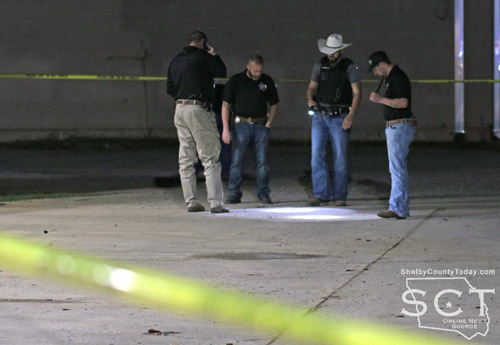
Constable Josh Tipton, Investigator Chad Hooper, Constable Taylor Fanguy and Investigator Aaron Jones examine area of the Timpson Quick Stop Car Wash.
Officers with the Shelby County Sheriff’s Department, Constables from Precincts 2,4, and 5 were all at the scene working together along with Texas Department of Public Safety.
The Shelby County Sheriff's Department has provided updated information on this incident and suspect, Michael Babee, is in custody. See more information here: Barbee in Custody Following Shooting Incident in Timpson
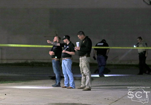
At around 9:16pm, officers performed a final sweep of the cordoned off area for any remaining evidence.
Related article: Barbee in Custody Following Shooting Incident in Timpson
Pages