
The story headline links to a better view of the story and share features.


News
Public Service Announcement (PSA) is being brought to you Shelby County Judge Allison Harbison and the Office of Emergency Management.
March 20, 2020 - First and foremost, I would like to thank the citizens of Shelby County for their response to the current health crisis. I am so proud of our businesses, industries, county and city governments, health associates and everyone who is working together to keep our County safe. I especially want to thank the businesses that supply groceries, medicine, and fuel to the public. With your continued efforts, we will keep everyone in Shelby County, safe, nourished, and virus free.
As of this morning, Shelby County has no reported COVID-19 cases. At this time I am issuing a Declaration of a Local State of Disaster Due to a Public Health Emergency. Again, we have no reported cases in the County; however, this Declaration is to reinforce Governor Abbott’s Executive Orders within our County.
The Declaration will also activate our Emergency Management Plan, so if we need State and Federal Assistance we will have the necessary documentation in place to request and receive such assistance.
All County Offices will be closed to the public, as of Monday, March 23. The offices will be staffed and you will be admitted on an as needed basis. If you would like to make an appointment with any office or official, all contact information has been shared with all media outlets and posted on the front of the offices.
Shelby County is at a pivotal moment in our response to COVID-19. At this time, there are still no confirmed cases of coronavirus in Shelby County or in our surrounding counties. The statewide confirmed case count has risen to 194 with 5 deaths being reported and over 5,000 having been tested.
The most effective way to prevent the spread of this virus is by promoting social distancing. Shelby County businesses, schools, churches and organizations have been extremely proactive early on by either cancelling and/or postponing events or offering alternative methods of delivering services and are to be commended for their efforts in their preemptive measures.
Texas Governor, Greg Abbott, issued executive orders yesterday in accordance with federal guidelines to mitigate the spread of COVID-19. The components of the executive order that directly affects the citizens of our county include:
- Avoiding social gatherings of more than 10 people.
- Avoid eating or drinking at bars, restaurants, and food courts, provided, however, that the use of drive-thru, pick-up, or delivery options is allowed and highly encouraged throughout the limited duration of the executive order.
- Avoid visiting gyms or massage parlors.
- People shall not visit nursing homes, retirement, or long term care facilities unless to provide critical assistance.
- Schools shall temporarily close.
These orders will be effective on a statewide basis beginning at 11:59 PM Friday March, 20th, 2020 and will remain in effect until 11:59 PM on Friday April, 3rd, 2020 and subject to extension based on the status of COVID-19 and recommendations of the CDC.
As a result of the statewide disaster declaration by Governor Abbott on March 13th and these recent executive orders issued by the Governor, Shelby County will file the necessary paperwork to the state of a Local Disaster Declaration. This is only a precautionary move to assist with any actions that need to be taken at a later date.
I ask everyone to remain calm but vigilant; our ultimate goal is to make sure Shelby County does their part to prevent the spread of COVID-19. Again, I want to thank our citizens and all of our partners within the county, together we will weather this storm and be stronger because of it.
Thank you,
Allison Harbison – Shelby County Judge/Emergency Management Director
Kerri Shofner – Shelby County Emergency Management Coordinator
March 20, 2020 - In efforts to help slow the COVID-19 outbreak, we are announcing a temporary closure to the public starting Monday, March 23rd, 2020 through April 3rd, 2020.
We will have staff in the offices to answer the phones and any questions that you may have.
We apologize for any inconvenience but the safety of our staff and our county residents are a main concern at this point. The offices will be staffed and you may set up appointments as necessary. Each Elected Official has the discretion for their office and may set additional guidelines.
List of County Offices and Phone numbers:
COUNTY JUDGE - 936-598-3863 or email judgeadmin@co.shelby.tx.us
INDIGENT HEALTHCARE OFFICE - 936-598-5611 or email judgeadmin@co.shelby.tx.us
COUNTY COMMISSIONERS OFFICE - 936-598-6136 or email commissioners@co.shelby.tx.us
- Commissioner Pct. 1 - Roscoe McSwain 936-591-4333
- Commissioner Pct. 2 - Jimmy Lout 936- 591-2456
- Commissioner Pct. 3 - Charles Barr 936-591-4311
- Commissioner Pct. 4 – Tom Bellmyer 936-254-4571
EMERGENCY MANAGEMENT COORDINATOR, Kerri Shofner - 936-598-3664 or email shelbyemc@co.shelby.tx.us
911 ADDRESSING - 936-598-5183 or email shelbycounty911@gmail.com
COUNTY CLERK - 936-598-6361
DISTRICT CLERK - 936-598-4164
TAX ASSESSOR - 936-598-4441 (Shelby County Tax Office / Motor Vehicle and Voter Registration Office Closure)
DMV - 936-598-8172
COUNTY TREASURER - 936-598-3581
COUNTY AUDITOR - 936-598-3535
DISTRICT ATTORNEY - 936-598-2489
COUNTY ATTORNEY - 936-598-6100
COUNTY AGENT - 936-598-3223
VETERAN’S OFFICE - 936-598-6530
VOTER’S REGISTRATION - 936-598-5340 (Shelby County Tax Office / Motor Vehicle and Voter Registration Office Closure)
SHERIFF DEPARTMENT - 936-598-6100 (Shelby County Judge Statement Regarding COVID-19 Update)
COURTHOUSE SECURITY - 936-598-3222
123RD DISTRICT JUDGE - 936-598-9928
273RD DISTRICT JUDGE - 936-598-3201
ADULT PROBATION - 936-598-2718
JUVENILE PROBATION - 936-598-4587
March 20, 2020 - The National Weather Service in Shreveport has issued a flood warning for the Attoyac Bayou Near Chireno, Texas from Sunday morning until further notice or until the warning is cancelled.
At 7:30am Friday the stage was 8.0 feet.
Minor flooding is forecast.
Flood stage is 14 feet.
Forecast...Rise above flood stage by late Sunday morning and continue to rise to near 14.9 feet by Monday early afternoon.
Impact...Minor lowland flooding.
Do not drive vehicles through flooded waterways. Use caution when walking near flooded riverbanks. Do not try to wade or swim in flooded rivers and bayous.
For additional hydrologic information, click the following link:
water.weather.gov/ahps2/index.php?wfo=shv
March 19, 2020 AUSTIN – At the direction of Governor Greg Abbott and in light of the governor’s State of Disaster Declaration related to the coronavirus disease 2019 (COVID-19), the Texas Department of Public Safety (DPS) has been directed to extend the expiration date of Texas identification cards (ID), driver licenses (DL), commercial DLs (CDL) and election identification certificates (EIC). Additionally, the department has been directed to close DL offices, effective Thursday, March 19, until directed to reopen by the governor. These actions come as the state works to limit the ongoing spread of COVID-19 by increasing social distancing in communities.
DRIVER LICENSE OFFICE CLOSURES
Effective Thursday, March 19, 2020, DL offices across the state have been closed until further notice. The temporary closure does not apply to individuals seeking an initial CDL. A number of DL offices across the state are designated as CDL sites — these offices will offer CDL testing by appointment only. If you already have a CDL skills test scheduled, that appointment remains valid. For those needing to schedule a CDL test, you can schedule an appointment by sending an email to cdlappointments@dps.texas.gov. Please include your name, DL number, date of birth, telephone number, email address and your preferred office location in your request.
DRIVER LICENSE EXTENSION
In accordance with section 418.016 of the Texas Government Code, the Office of the Governor approved DPS’ request to suspend provisions of the Texas Transportation Code to the extent necessary to delay the expiration of Texas DL/CDL/ID/EIC cards. This means that if your Texas DL/CDL/ID/EIC card expires on or after March 13, 2020, it falls under the period that encompasses the State of Disaster Declaration related to COVID-19 and will remain valid for 60 days after which time DPS issues public notice that the extension period for this disaster declaration has been lifted.
It’s important to note that this extension applies to the expiration date only. A person who is not eligible to drive due to an active enforcement action (suspension, revocation or denial) may use the card for identity purposes only.
DPS is communicating with law enforcement agencies across the state to notify and inform them about the changes and what the extension means for their interactions with the public.
ONLINE SERVICES AVAILABLE FOR TEXANS
The majority of customers who come into Texas DL offices (for example, 3.2 million people in Fiscal Year 2019) don’t have to. These customers can actually conduct their transaction online, by phone or by mail. DPS encourages Texans to check the expiration date on their card and call 1-866-DL-RENEW (1-886-357-3639) or visit Texas.gov to see if you’re eligible to conduct your transaction online, particularly in light of the closures due to the COVID-19 pandemic.
The fee is the same for online, in-person and telephone renewals. For additional information about renewing your DL or ID card, visit the DPS website. Address changes and replacement of a lost DL or ID can also be taken care of online (or by mail) in many instances. Find out if you are eligible for online services by visiting Texas.gov.
WHEN WILL YOUR OFFICES REOPEN?
The department continues to be in constant communication with state leadership regarding this rapidly changing situation. The department will follow guidelines set by the governor as to when our offices will reopen and will keep the public informed as the situation continues to evolve.
ADDITIONAL RESOURCES
- DPS DL COVID-19 Informational Web Page
- Governor Abbott, DPS Waive Expiration Dates for Driver Licenses, March 18, 2020 (view here)
- Governor Abbott Announces Temporary Closure of Driver License Offices, March 18, 2020 (view here)
- Governor Abbott Holds Press Conference on Coronavirus, Declares State of Disaster for All Texas Counties, March 13, 2020 (Announcement | Declaration)
- DPS Takes Preventative Measures Against COVID-19, Encourages Texans to do the Same, March 12, 2020 (view here)
March 19, 2020 - Texas Health and Human Services encourages all Texans in need of COVID-19 information and referrals to community resources to call the 2-1-1 Texas hotline 24 hours a day, 7 days a week.
“As we encourage people to use social distancing and to stay at home when possible, this state resource can help the public stay informed, stay calm and stay safe,” said Wayne Salter, HHS Deputy Executive Commissioner of Access and Eligibility Services. “Our trained staff are working tirelessly around the clock to respond to all the public’s questions, through 2-1-1 as well as our HHS social media platforms.”
Did You Know? DETCOG operates one of 25 Area Information Centers that are part of the 2-1-1 Texas network. Our Deep East Texas call center handles an average of 30,000 calls each year.
Texans, no matter where they live, can dial 2-1-1 or (877) 541-7905 and select option 6 to get information and referrals to COVID-19 social services, including testing, community clinics, unemployment benefits and more. Texans can also dial 2-1-1 to find information about local community resources such as financial assistance for utilities or rent and food pantries, housing assistance, crisis counseling, utility payment assistance, and senior services.
Call center operators answered more than 785,000 calls by Texans for information and services during Hurricane Harvey and are available to help during this public health crisis.
For general health-related information and precautions on COVID-19, visit the DSHS website and the CDC page.
Stay up-to-date on the latest news and updates impacting HHS services and regulated providers by visiting the HHS COVID-19 page.
For more information on the state hotline, visit 211texas.org.
March 19, 2020 - The City of Center wants to reassure our residents and businesses that essential City services are not anticipated to be affected by the COVID-19 pandemic. We are following our emergency response plans and taking necessary steps to ensure we can continue to serve our citizens. The City will be enhancing emergency response services by the Center Police and Fire Departments. Also, City water, sewer and garbage services should not be interrupted. The City will make some operational modifications consistent with guidance from the Centers for Disease Control and Prevention (CDC) and today’s Emergency Order by Governor Abbott in efforts to reduce in-person interactions for city business and postpone public events of ten or more persons. These steps are being taken to protect staff, customers, the public health and particularly our most vulnerable citizens.
The City is taking measures to ensure the continuity of services throughout the community including communications with local medical facilities, industry partners, retail businesses and other utility providers. Center Police and Fire personnel are coordinating with other emergency responders. Public Safety contacts remain 936/598-2788 for the Center Police Department and 936/598-3288 for the Center Fire Department. If anyone requires emergency services, they still call 9-1-1. The Center Police and Fire Stations will limit access to the public to reduce contact as a precaution for the individual health of our public safety personnel.
City water and sewer utility service will continue. The City is operating both water plants on regular schedule so that all water needed is available and in compliance with all drinking water standards. City utility plants and the City annex on Riggs Street will also limit public access. If anyone has utility or public works requests, call 936/598-2941 to initiate a response.
The Governor’s current order inhibits many business operations and we encourage all citizens and residents to continue to support local businesses that continue operations in adjusted fashion to comply with the Governor’s statewide health order. The Center Economic Development Corporation staff has been directed to monitor State of Texas and US Small Business Administration programs for resources, information and potential aid for businesses affected by COVID-19 and will provide information on the City website as it becomes available. Staff remain available to answer any questions at 936/598-2941.
The CDC and TxDSHS encourage individual preventative measures:
- Frequently washing hands;
- Staying at home if you have any symptoms of illness, especially fever or difficulty breathing;
- Avoiding close personal contact with people, such as shaking hands; and
- Frequently disinfecting surfaces at home and in the workplace.
Additional recommendations of the CDC and TXDept of State Health Services include start practicing social distancing by:
- staying away from other people to avoid catching or spreading illness;
- avoiding crowds and minimizing physical contact; and
- staying at least six feet away from others Operational Modifications/Update:
City Hall will also reduce public access. Customers can call 936/598-2941 for assistance or with questions including need to talk directly to personnel. To make a utility payment or service changes, the options include:
- The payment kiosk at City Hall open 24/7 accepts cash, checks, and credit/debit cards
- The night drop box at City Hall for cash or checks
- The online payment portal at www.CenterTexas.org is now available
- For additional assistance, please call 936/598-2941.
The Center Municipal Court, located at the Center Police Station is also closed to the public. Anyone wishing to resolve a ticket or citation can make payments via:
- Online at trafficpayment.com
- Mailing plea with money order to P.O. Box 1900, Center, Texas 75935
- Calling 936/598-3080 with questions or additional assistance.
Garbage collection is continuing regular Tuesday/Friday or Monday/Thursday schedules for residences and daily scheduled collection for all commercial accounts. Bulky waste disposal at the Riggs St. Annex is temporarily unavailable.
All athletic activities coordinated by Center Recreation Department are temporarily postponed. While City parks, pavilions, playgrounds, and cemeteries remain open at this time, all are encouraged to follow the recommended health and safety protocols, including the Governor’s order prohibiting gatherings of more than 10 persons, social distancing and individual prevention.
The John D. Windham Civic Center and Community House staff will coordinate the postponing or rescheduling events at no additional cost to renters to honor Governor Abbott’s order of no meetings larger than ten persons until April 3rd. All public events until April have been postponed by event coordinators.
The Center Municipal Airport will remain open to accommodate aviation needs and there are currently no restrictions on flight operations.
March 19, 2020 -Texas Attorney General Ken Paxton continues to caution Texans about scams emerging during the statewide Coronavirus disaster declaration announced by Governor Abbott last Friday.
Several cyber scams involving false emails or text messages have been reported, and Attorney General Paxton advises all Texans to be on alert for electronic communications with dangerous attachments or fraudulent website links. Unscrupulous actors send these messages with the intention of deceiving citizens into revealing sensitive information or donating to false charities. Any email or social media post with a Coronavirus (COVID-19) subject line, attachment or hyperlink should be treated with caution.
Remember these tips to avoid cyber scams:
- Avoid clicking on links in unsolicited emails and be wary of email attachments.
- Use trusted sources like legitimate, government websites for up-to-date, fact-based information about COVID-19.
- Do not reveal any personal or financial information in an email, and do not respond to any email solicitations for this information.
- Verify a charity’s authenticity before making donations.
The current disaster declaration is effective across the entire state, and under Texas consumer protection statutes, it is illegal for a person to take advantage of a disaster declaration by engaging in deceptive trade practices.
Texans who believe they have encountered disaster scams should call the Office of the Attorney General’s toll-free complaint line at (800) 621-0508 or file a complaint online. For additional information on disaster scams, please visit our disaster scams website.
For information on the spread or treatment of Coronavirus (COVID-19), please visit the Texas Department of State Health Services.
To Shelby County Residents:
March 18, 2020 - I would like to take this opportunity to provide an update on the very fluid situation surrounding the COVID-19 (Coronavirus) Pandemic. Myself and the Emergency Management Coordinator, Kerri Shofner, are continuing to monitor information and participate in conference calls with The Department of State Health Services (DSHS) and Texas Division of Emergency Management (TDEM).
As of 1:00 PM March 18th (most recent conference call) there are 83 confirmed cases of COVID-19 in the state of Texas and 2 confirmed deaths. Approximately 1,900 COVID-19 tests have been performed state wide. We currently have no COVID-19 positive test results being reported to us for Shelby County. And have been assured that if that should occur, DSHS will notify county officials.
Many Shelby County businesses, churches, and organizations have reached out to us for guidance on closures and/or limiting services. We have advised them to refer to guidelines set by the Centers for Disease Control & Prevention (CDC) and DSHS.
All the guidelines set by the aforementioned agencies highly recommend social distancing as the most effective way possible to prevent the spread of the disease.
I would like to take this opportunity to thank all the businesses, schools, churches, and organizations that have adhered to these recommendations by closing, using alternative methods for doing businesses, and cancelling and/or postponing events & meetings. Your proactive efforts to practice social distancing and avoid the spread of the coronavirus and help insure the continued good health of populations most susceptible to the virus are to be applauded.
Please continue to provide all local media outlets & social media outlets of all closings, cancellations, rescheduling & alternative business methods. This will aid tremendously in keeping the public informed of all pertinent information.
Please refer to the following web sites to keep abreast of all COVID-19 information/recommendations:
We will continue to monitor the situation and will provide the public with information as it is provided to us.
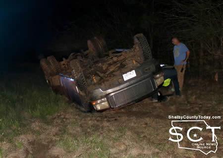
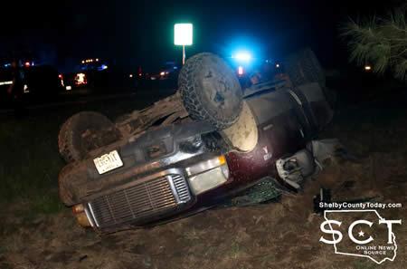
March 17, 2020 - FM 1970 South just before County Road 4755 was the scene of a single-vehicle rollover crash Thursday, March 12, 2020 at around 7:50pm.
According to Texas Department of Public Safety (DPS) State Trooper Taylor Buster, a maroon 1999 Ford F-350 driven by Logan Yates, 19, of Timpson was northbound on FM 1970 South. The truck was traveling at an unsafe speed for the curve in the roadway.
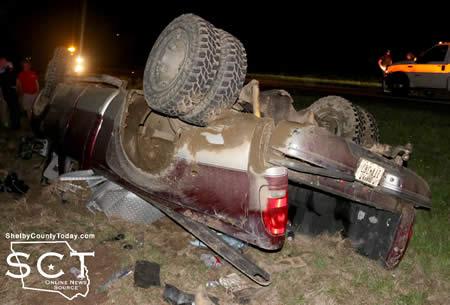
Yates tooks faulty evasive action traveling into the oncoming lane and leaving the roadway where the vehicle rolled and came to rest on its top.
Emergency personnel with the Timpson Volunteer Ambulance Service was dispatched to the scene.
Yates was charged with unsafe speed and driving while intoxicated. He was later taken into custody and transported by Texas DPS State Trooper Dustin Ramos.
According to the Shelby County Jail log, Yates was arrested for driving while intoxicated.
March 16, 2020 - In an effort to reduce the need for in-person transactions, the Texas Department of Motor Vehicles (TxDMV) worked with Governor Greg Abbott and our stakeholders to temporarily waive certain requirements for vehicle registration, vehicle titling and disabled parking placards.
On March 13, 2020, Governor Greg Abbott issued a proclamation, declaring a state of disaster for all counties in Texas due to the threat of COVID-19. Governor Abbott also issued a statement on March 16, 2020, granting a temporary extension to obtain initial registration, renewal of registration, vehicle titling, and renewal of a permanent disabled parking placard. Governor Abbott also granted a temporary extension for an individual with an expired 30-day temporary permit to obtain another permit or Texas registration.
The temporary waiver applies to vehicle owners in all Texas counties as set forth in the above-referenced proclamation and statement. This temporary waiver is in effect until 60 days after TxDMV notifies the public that normal vehicle registration, vehicle titling and related services have resumed. The 60-day period will be the same for all counties.
The purpose of the waiver is to prevent customers from having to physically visit a county tax assessor-collector office to obtain initial registration, to obtain a 30-day temporary permit, to transfer title; or to renew registration or a permanent disabled parking placard. Customers may continue to renew their registration online at www.TxDMV.gov. At this time, TxDMV continues to fill online registration sticker requests and process all other online services.
TxDMV has informed law enforcement agencies and the offices of the county tax assessor-collectors of the temporary waiver.
Pages