

The story headline links to a better view of the story and share features.


News
9:53 AM CST Monday, January 15, 2018
January 15, 2018 - The National Weather Service, Shreveport, Louisiana advises a Winter Storm Warning remains in effect from this evening through Tuesday for much of Northeast Texas, Southwest Arkansas, and Northwest Louisiana.
Also, a Winter Weather Advisory remains in effect from early this evening through noon tomorrow for extreme Southeast Oklahoma, and adjacent sections of Northeast Texas and Southwest Arkansas. The Winter Weather Advisory is now in effect for Deep East Texas, and much of North Louisiana along and south of Interstate 20.
The Winter Weather advisory is for Lincoln, De Soto, Red River, Bienville, Jackson, Ouachita, Sabine, Natchitoches, Winn, Grant, Caldwell, La Salle, Nacogdoches, Shelby, Angelina, and San Augustine and includes the cities of Ruston, Mansfield, Stonewall, Logansport, Coushatta, Martin, Arcadia, Ringgold, Gibsland, Jonesboro, Monroe, Many, Zwolle, Pleasant Hill, Natchitoches, Winnfield, Colfax, Montgomery, Dry Prong, Clarks, Grayson, Columbia, Jena, Midway, Olla, Nacogdoches, Center, Lufkin, San Augustine, Hemphill, and Pineland.
The Winter Weather Advisory is in effect from 3am to 6pm CST Tuesday, January 16, 2018. Periods of light to moderate snow are expected. Plan on slippery road conditions, including during the Tuesday morning commute. Expect total snow accumulations of up to one inch with isolated higher amounts possible for much of North Louisiana and all of Deep East Texas.
Additional Details... Look for reduced visibilities at times.
Precautionary/Preparedness Actions - A Winter Weather Advisory for snow means periods of snow will cause primarily travel difficulties. Be prepared for snow covered roads and limited visibilities, and use caution while driving. The latest road conditions for the state you are calling from can be obtained by calling 5-1-1.
January 12, 2018 - The Shelby County Sheriff’s Office warns area residents of a scam circulating.
The caller is impersonating a law enforcement officer with the Shelby County Sheriff’s Office. The caller is stating they have warrants for not appearing for a grand jury summons. The caller will request that you pay court costs and/or a retainer fee.
The number the caller is using belongs to a Shelby County employee. Once the call is answered, the caller will give instructions to call what appears to be a switchboard at the Shelby County Courthouse. They will ask you for your credit card information. This is a scam. Do not give out any information.
If you have any questions concerning this scam, please contact the Shelby County Sheriff’s Office at 936-598-5601.
(4:56pm) - Shelby County Today has received reports individuals have been receiving scam calls claiming they will be fined for having not attended grand jury or jury service. It has even been indicated an amount demanded by the scammers was up to $2,000.
Anyone receiving such calls should contact their nearest law enforcement entity, and never give personal information over the phone when a caller is demanding payment.
Lori Oliver, Shelby County District Clerk, has confirmed it is not procedure for the court system to call someone in an attempt to collect a fine for failure to report to jury service or grand jury service.
National Weather Service, Shreveport, LA
11:27am CST Friday, January 12, 2018
January 12, 2018 - This Hazardous Weather Outlook is for portions of south central Arkansas, southwest Arkansas, north central Louisiana, northwest Louisiana, southeast Oklahoma, east Texas and northeast Texas including Sevier, Howard, Little River, Hempstead, Nevada, Miller, Lafayette, Columbia, Union, Caddo, Bossier, Webster, Claiborne, Lincoln, De Soto, Red River, Bienville, Jackson, Ouachita, Sabine, Natchitoches, Winn, Grant, Caldwell, La Salle, McCurtain, Bowie, Franklin, Titus, Camp, Morris, Cass, Wood, Upshur, Marion, Smith, Gregg, Harrison, Cherokee, Rusk, Panola, Nacogdoches, Shelby, Angelina, and San Augustine.
DAY ONE... This Afternoon and Tonight...
No hazardous weather is expected.
DAYS TWO THROUGH SEVEN... Saturday through Thursday...
After a very cold and dry weekend, another Arctic cold front will arrive Monday night. Temperatures will fall to below freezing once again, and rain will begin mixing with freezing rain, sleet and snow. There is still a lot of uncertainty in the forecast for this event, but some accumulation of wintry precipitation does appear possible at this time.
.SPOTTER INFORMATION STATEMENT... Activation of emergency managers, skywarn networks, and amateur radio operators will not be needed through the weekend.
 January 12, 2018 - (Update): Andrea Chadwick was arrested in Panola County on January 11, 2018. She was transported to the SCSO January 12.
She has been charged with: Theft of Livestock; Theft - $15,000 Bond; Burglary of Habitation - $5,000 Bond; Fraud Use/Poss of Identifying Info against the Elderly - $15,000; and Theft against the Elderly - $20,000.
January 10, 2018 - The Shelby County Sheriff’s Office is seeking the whereabouts of Andrea Janise Chadwick. Chadwick is 5’7’ and weighs approximately 155 pounds. She has brown hair and green eyes. Her last known address is in Shelbyville.
Chadwick has active warrants in Shelby County. If you have information on her whereabouts, please contact SCSO Chief Deputy Kevin Windham at 936-5272-1972 or 936-598-5601.
If anyone is found to be hindering the apprehension, harboring or concealing, providing or aiding with any means of avoiding arrest or effecting escape, or warns Chadwick of impending discovery or apprehension, will be arrested and charged in accordance to Penal Code 38.05 Hindering Apprehension or Prosecution, a Felony 3 offense.

January 12, 2018 - Hom/Ade Foods, Inc is voluntarily recalling Mary B’s® brand biscuits due to potential contamination with Listeria monocytogenes. The problem was discovered in a product sampling conducted by an outside co-packer, who manufactured the product. Listeria monocytogenes is an organism which can cause serious and sometimes fatal infections in young children, frail or elderly people, and others with weakened immune systems. Although healthy individuals may suffer only short-term symptoms such as high fever, severe headache, stiffness, nausea, abdominal pain and diarrhea, Listeria infection can cause miscarriages and stillbirths among pregnant women.
The Mary B’s products affected are frozen bagged biscuits with the UPC codes listed below. All “Best If Used By” dates Before September 23, 2018 and with the letter “M” immediately after the date are included in the recall. The code may be found on the back of the bag, lower right corner. No other code dates are affected.
Upc #, Description, Count Per Package
- 2059300007 Mary B’s Jumbo Buttermilk Biscuits, 35oz 10 / 3.5oz
- 2059300015 Mary B’s Buttermilk Biscuits 26.4oz 12 / 2.2oz
- 2059300018 Mary B’s Southernmade Biscuits 26.4oz 12 / 2.2oz
- 2059300020 Mary B’s Buttermilk Value Pack Biscuits 44oz 20 / 2.2oz
- 2059300021 Mary B’s Southernmade Value Pack Biscuits 44oz 20 / 2.2oz
- 2059300022 Mary B’s Buttermilk Tea Biscuits 24oz 24 / 1oz
- 2059300023 Mary B’s Buttertaste Value Pack Biscuits 44oz 20 / 2.2oz
- 2059300028 Mary B’s Thin Buttermilk Biscuits 28.6oz 22 / 1.3oz
- 2059300033 Mary B’s Buttermilk Family Pack Biscuits 60oz 30 / 2oz
- 2059300034 Mary B’s Southernmade Family Pack Biscuits 60oz 30 / 2oz
- 2059300035 Mary B’s Buttertaste Family Pack Biscuits 60oz 30 / 2oz
- 2059383000 Mary B’s Buttermilk 0 Trans Fat 220ct Bulk Biscuits 220 / 2.2oz
- 2059383004 Mary B’s Buttermilk Biscuits 220ct Bulk Biscuits 220 / 2.2oz
- 2059387000 Mary B’s Made With Whole Grain 220ct Bulk Biscuits 220 / 2.2oz
- 3059320583 Mary B’s 3.5 Oz Jumbo Buttermilk 144ct Bulk Biscuits 144 / 3.5oz
Click here to view each individual package included in the recall
Products were distributed to AL, AR, CA, FL, GA, IL, IN, KS, KY, LA, MD, MO, MS, NC, OK, OR, PA, SC, TN, TX, VA, WI, WV and sold in retail stores. Although these products are not ready-to-eat items and have baking instructions which, if followed, will reduce consumer risk, there remains some risk that the mishandling of this product prior to or without adequate baking may cause illness.
There has been no illness to date associated with these products. Hom/Ade Foods Inc. has voluntarily recalled all affected products and is working with the FDA and supplier to fix the problem. Consumers are urged to return affected products to the place of purchase for a full refund. Customers or consumers with questions may call Hom/Ade Foods Inc. at 1-855-562-7773, Monday to Friday, between 8 a.m. and 5 p.m. Central Time.
January 11, 2018 - Rainy weather conditions are proving to be a hazard for Shelby County drivers as traffic incidents are keeping DPS Troopers busy responding to such situations.
Some have been more minor incidents of a driver losing control on a roadway and merely coming to rest on the shoulder, while others have come into contact with objects on the side of the road causing crashes.
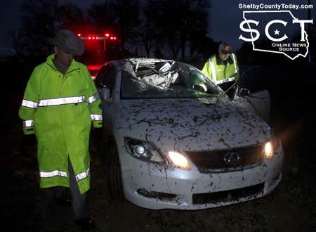
According to Texas Department of Public Safety State Trooper Dustin Ramos, at 5:10pm Thursday, January 11, 2018, DPS Troopers were dispatched to a single-vehicle crash on U.S. Highway 96 South at the intersection of County Roads 1015 and 1021.
Upon arrival, it was determined a white 2007 Lexus owned and driven by Carlos Johnson, Jr., 18, of San Augustine was northbound on U.S. Highway 96 at an unsafe speed for wet roadway conditions and traveled off the roadway to the right. As the Lexus continued traveling it struck multiple bushes and tree branches, causing damage to the front and coming to rest off the roadway with damage.
Johnson was transported by ACE EMS to Nacogdoches Medical Center - Shelby Emergency Department for treatment of minor injuries.

Johnson was issued a citation for unsafe speed.
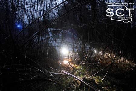
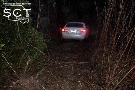
Immediately following the crash scene being cleared at around 6pm, DPS Troopers were dispatched to another crash incident on U.S. 96 North at Flat Fork Creek.
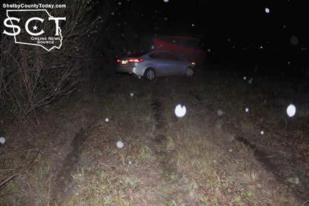
Upon arrival, the troopers discovered a silver Kia which had traveled off the roadway to the left and through a fence before coming to rest in a boggy area. Injuries were not apparent as the drive of the vehicle was not transported from the scene by ambulance and instead was interviewed by DPS Troopers before being released.
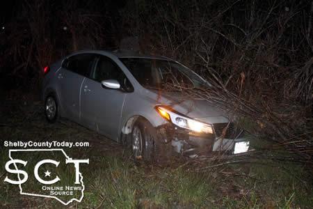
Drivers traveling during the wet weather are urged to use extra caution to help decrease the occurrence of incidents.


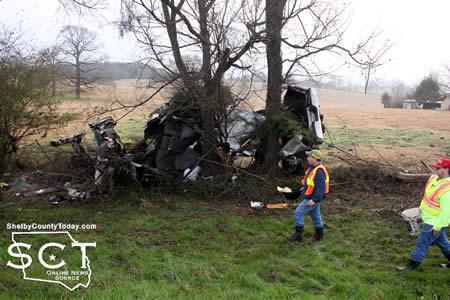
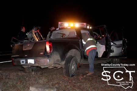
January 11, 2018 - The driver involved in a major crash on FM 711, which left the vehicle involved unrecognizable, is in Tyler at ETMC hospital for treatment.
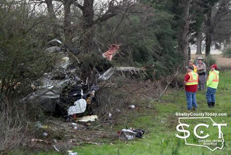
According to Texas Department of Public Safety State Trooper Jesse Fountain, at 7:20am January 11, 2018 troopers were dispatched to a one-vehicle crash just over 1/4 mile south of CR 1005 in the Jericho Community involving a silver 2002 Dodge 2500 SLT pickup truck driven by Allen Joseph McSwain, 32, of Center.
Indications are McSwain fell asleep while traveling northbound on FM 711 and ran off the road striking several trees along the way. During that time he was ejected from the Dodge.
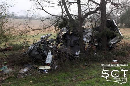
McSwain stated the crash occurred at around 4am.
McSwain was transported by ACE EMS to Nacogdoches Medical Center - Shelby Emergency Department before being taken by ambulance to ETMC in Tyler for treatment of his injuries.
West Shelby County Volunteer Firemen were on scene to provide assistance. Damage to the vehicle was so severe, it was hauled away in separate sections by Hughes Wrecker Service. A neighbor and the owner of the property where the crash occurred offered the use of tractor equipment to help move the truck.
 \
\


January 11, 2018 - The public water system has taken the necessary corrective actions to restore the quality of the water distributed by this public water system used for drinking water or human consumption purposes and has provided TCEQ with laboratory test results that indicate that the water no longer requires boiling prior to use as of 1/11/2018. If you have questions concerning this matter, you may contact Derek Diverdi at 936-332-7683.
January 4, 2018 - Due to a break in the main line, the Texas Commission on Environmental Quality has required the Paxton public water system ID# 2100031 to notify all customers on Hwy 7, FM 139 Hwy 84 , that were without water, to boil their water prior to consumption (e.g., washing hands/face, brushing teeth, drinking, etc). Children, seniors, and persons with weakened immune systems are particularly vulnerable to harmful bacteria, and all customers should follow these directions).
To ensure destruction of all harmful bacteria and other microbes, water for drinking, cooking, and ice making should be boiled and cooled prior to use for drinking water or human consumption purposes. The water should be brought to a vigorous rolling boil and then boiled for two minutes.
In lieu of boiling, individuals may purchase bottled water or obtain water from some other suitable source for drinking water or human consumption purposes.
When it is no longer necessary to boil the water, the public water system officials will notify customers that the water is safe for drinking water or human consumption purposes.
Once the boil water notice is no longer in effect, the public water system will issue a notice to customers that rescinds the boil water notice in a manner similar to this notice.
Please share this information with all the other people who drink this water, especially those who may not have received this notice directly (for example, people in apartments, nursing homes, schools, and businesses). You can do this by posting this notice in a public place or distributing copies by hand or mail.
If you have questions concerning this matter, you may contact Derek Di Verdi at 936-332-7683
 January 10, 2018 - The Shelby County Sheriff’s Office is seeking the whereabouts of 54 year-old Teresa Glynn Stephens. Stephens was last seen in Shelby County in the Spring of 2016. Stephens may also go by the names Teresa Glynn Roof or Teresa Glynn Kocyba. She is described as a white female, 5’10” and 200 pounds.
Stephens has ties to South Carolina, Florida, Georgia, Missouri and Texas City, Tx.
If anyone has any information regarding her whereabouts or any information on Stephens, you are urged to contact Shelby County Sheriff’s Office Chief Deputy Kevin Windham at (936) 598-5601 or (936) 572-1972.

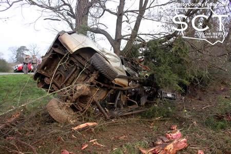
January 10, 2018 - FM 417 west of Shelbyville was the scene of a major single-vehicle crash Friday, January 5, 2018 which left the driver trapped.

According to Texas Department of Public Safety State Trooper Richard Hill, at 5:45pm a black Nissan Frontier with white racing stripes and driven by Raul Resendiz, 18, of Joaquin was westbound on FM 417 one mile past the FM 2694 intersection. Witnesses stated the Frontier was traveling about 75 miles per hour and Resendiz stated he reached down to get his phone, during which time he traveled straight through a curve in the roadway and off the roadway to the left before striking two trees.

Center Fire Department was dispatched to the scene with Jaws of Life to assist Shelbyville Volunteer Fire Department in extricating Resendiz from the vehicle.
ACE EMS transported Resendiz from the scene for treatment of injuries.
He was issued citations for driving while intoxicated and unsafe speed.

Pages