

The story headline links to a better view of the story and share features.


News
April 6, 2018 - A Shelby County Justice of the Peace is currently under investigation by the Texas Rangers and District Attorney's Office.
According to information provided to Shelby County Today by Stephen Shires, Shelby County District Attorney through an open records request, Jenny Hicks - Precinct 4 Justice of the Peace has been under investigation by the Texas Rangers for the alleged offense of Theft by Public Servant/Official Misconduct.
The information provided by the District Attorney goes on to explain the then-Mayor Carl Jernigan and then-City Marshal Jimmy Wagstaff discovered what they believed were certain suspicious resolutions of a handful of traffic violation cases handled by Judge Hicks while she was City of Tenaha Municipal Court Judge.
According to Shires, when the matter was brought to his attention, he referred the matter to the Texas Ranger Public Integrity Unit for investigation. This was followed by a preliminary investigation conducted by the Rangers.
The collection of additional information is anticipated by the DA, which he says is germane to the investigation, and once it has been collected it will be shared with the Rangers who will then finalize their investigation. At that time Shires can move forward with whatever action may be necessary.
Shelby County Today has been seeking confirmation on the allegations for several months from all agencies and public entities involved including the City of Tenaha, Shelby County District Attorney's Office, and Texas Department of Public Safety.
Since the case is still under investigation, it is the right of law enforcement entities to withold information until an investigation has been completed; however, a point of argument for Shelby County Today has been the basic information of the investigation can't be witheld and this was confirmed by the Texas Attorney General's office.
Although the City of Tenaha attorney's did not agree with the Texas Attorney General ruling and did not provide the requested information, the Shelby County District Attorney complied with the rule of law and shared the requested information with Shelby County Today.
At this time it's unknown how much money is in question regarding the "suspicious resolutions."
Hicks was Municipal Court Judge in Tenaha from June 11, 2009 until 2016 when Elizabeth Swint was sworn in as her replacement November 1 of that year.
More information on this investigation will be provided as it is made available.
9:12pm CDT, Friday, April 6, 2018
April 6, 2018 - The National Weather Service in Shreveport has issued a Severe Thunderstorm Warning for Southwestern De Soto Parish in northwestern Louisiana, Western Sabine Parish in northwestern Louisiana, Southwestern Panola County in northeastern Texas, Southeastern Rusk County in northeastern Texas, Nacogdoches County in eastern Texas, Shelby County in eastern Texas, North central Angelina County in eastern Texas, San Augustine County in eastern Texas, and Sabine County in eastern Texas until 10:00pm CDT.
At 9:11 PM CDT, a severe thunderstorm was located near Garrison, or 20 miles southwest of Carthage, moving southeast at 35 mph.
HAZARD...60 mph wind gusts and half dollar size hail.
SOURCE...Radar indicated.
IMPACT...Hail damage to vehicles is expected. Expect wind damage to roofs, siding, and trees.
Locations impacted include Nacogdoches, Center, Milam, San Augustine, Hemphill, Tenaha, Timpson, Garrison, Pineland, Melrose, Patroon, Martinsville, Bland Lake, Neuville, Woden, Rosevine, Etoile, Macune, Shelbyville and Appleby.
PRECAUTIONARY/PREPAREDNESS ACTIONS... For your protection move to an interior room on the lowest floor of a building.
A tornado watch remains in effect until 11:00 PM CDT for northwestern Louisiana and eastern and northeastern Texas.
8:44pm CDT, Friday, April 6, 2018
April 6, 2018 - The National Weather Service in Shreveport has issued a Tornado Warning for Central Shelby County in eastern Texas and North central San Augustine County in eastern Texas until 9:15pm CDT.
At 8:44pm CDT, a severe thunderstorm capable of producing a tornado was located 9 miles south of Timpson, or 9 miles west of Center, moving southeast at 40 mph.
HAZARD...Tornado and quarter size hail.
SOURCE...Radar indicated rotation.
IMPACT...Flying debris will be dangerous to those caught without shelter. Mobile homes will be damaged or destroyed. Damage to roofs, windows, and vehicles will occur. Tree damage is likely.
This dangerous storm will be near Center around 8:55 PM CDT. Neuville and Shelbyville around 9:05 PM CDT.
Other locations impacted by this tornadic thunderstorm include Hurstown, Arcadia, Calgary, Jericho, Stockman, Jordans Store and Huxley.
PRECAUTIONARY/PREPAREDNESS ACTIONS...
TAKE COVER NOW! Move to a basement or an interior room on the lowest floor of a sturdy building. Avoid windows. If you are outdoors, in a mobile home, or in a vehicle, move to the closest substantial shelter and protect yourself from flying debris.
Tornadoes are extremely difficult to see and confirm at night. Do not wait to see or hear the tornado. TAKE COVER NOW!
Tornado Watch Outline Update for WT36
April 6, 2018 - National Weather Service Storm Prediction Center, Norman, OK, issued at 3:20pm CDT, on Friday, April 6, 2018 a Tornado Watch.
Tornado Watch 36 is in effect until 11:00pm CDT for the following locations (Texas Counties) Angelina, Bowie, Camp, Cass, Cherokee, Franklin, Gregg, Harrison, Marion, Morris, Nacogdoches, Panola, Red River, Rusk, Sabine, San Augustine, Shelby, Smith, Titus, Upshur, and Wood.
Hazardous Weather Outlook
The Nation Weather Service, Shreveport, LA, issued a Hazardous Weather Outlook at 12:03pm CDT, Friday, April 6, 2018 for Sevier, Howard, Little River, Hempstead, Nevada, Miller, Lafayette, Columbia, Union, Caddo, Bossier, Webster, Claiborne, Lincoln, De Soto, Red River, Bienville, Jackson, Ouachita, Sabine, Natchitoches, Winn, Grant, Caldwell, La Salle, McCurtain, Bowie, Franklin, Titus, Camp, Morris, Cass, Wood, Upshur, Marion, Smith, Gregg, Harrison, Cherokee, Rusk, Panola, Nacogdoches, Shelby, Angelina, and San Augustine.
This Hazardous Weather Outlook is for portions of south central Arkansas, southwest Arkansas, north central Louisiana, northwest Louisiana, southeast Oklahoma, east Texas and northeast Texas.
This Afternoon and Tonight... Thunderstorms will gradually become more widespread and increase in intensity across our northern areas early this afternoon, with a few damaging wind gusts possible. The threat for severe storms will increase significantly as we move into the mid to late afternoon and evening hours, as a cold front brings these storms southward across the entire region. Damaging winds and large hail will be the primary threats, but a few tornadoes and even some localized flooding cannot be ruled out. The threat for severe storms will gradually diminish during the overnight hours, as the cold front moves away from our area.
Saturday through Thursday... No hazardous weather is expected at this time.
Spotter Information Statement... Activation of emergency management personnel, amateur radio operators, and storm spotters will likely be needed by late this afternoon through this evening.
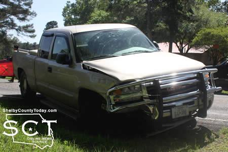
April, 5, 2018 - State Highway 87 south of Shelbyville was the scene of a three-vehicle crash which also involved a boat on Wednesday, April 5, 2018.
According to Texas Department of Public Safety State Trooper Dustin Ramos, at 2:50pm a beige 2004 GMC C1500 pickup truck driven by Charles Adams, 81, of Center was northbound on State Highway 87 near CR 2100 when the GMC failed to drive in a single lane due to a medical issue.

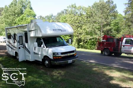
When the GMC traveled into the southbound lane it struck a white 2014 Freedom RV driven by Douglas Alan Loggins, 63, of Granbury with passenger Thomas Pavillard, 74, in its left rear quarter panel with the front left quarter of the GMC, causing damage.
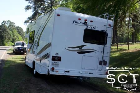
The GMC continued in the southbound lane where it struck a boat trailer being hauled by a red 2001 Dodge Ram 3500 driven by Douglas Brock Loggins, 30, of Weatherford. That collision included the right front of the GMC and causing right distributed damage to the trailer and to the truck. The collison also caused a Skeeter boat on the trailer to be ejected.
All vehicles involved came to rest in the roadway.

Adams was transported by ACE EMS to Nacogdoches Medical Center - Shelby Emergency Department for treatment. He was also issued a citation for failure to drive in a single lane.
Shelbyville Volunteer Firemen were on scene to direct traffic around the scene and they were assisted by a construction crew who had been working on culverts beside the roadway.

April 5, 2018 - The jury that has been summoned for Monday, April 9, 2018 for the 123rd District Court Honorable Leann Kay Rafferty presiding has been cancelled due to the scheduled cases being resolved or passed.
Anyone receiving a summons for that day is released from jury service until they receive a future summons.
Thank you,
Lori Oliver
District Clerk
Shelby County, Texas

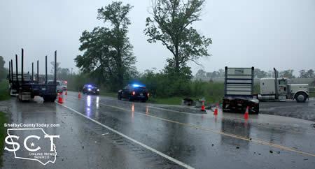
April 5, 2018 - U.S. Highway 84 outside of Tenaha was the scene of a two-vehicle crash involving 18-wheelers Tuesday, April 3, 2018.
Tenaha Volunteer Fire Department personnel were on scene to assist with the crash and direct traffic around the scene.
According to Texas Department of Public Safety State Trooper Dustin Ramos, at 3:40pm a white 2007 Peterbilt truck-tractor owned by Viking Transport LLC. and driven by Gregory Beard, 30, of Monroe, La. was westbound on U.S. Highway 84 just east of Tenaha when Beard began slowing to turn right while towing a trailer.
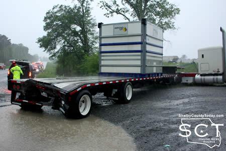
At that time, a white 2001 Volvo truck-tractor owned by DCE Services LLC. and hauling an empty trailer was driven by Tracy Osby, 50, of Center and was traveling in the same direction behind the Peterbilt. The Volvo failed to control speed and struck the rear of the trailer being hauled by the Peterbilt and causing distributed damage to the front of the Volvo.
The Volvo and the trailer it was hauling came to rest in the eastbound traffic lane. The Peterbilt and the trailer it was hauling came to rest in a private drive.

Beard was transported by ACE EMS to Nacogdoches Memorial Hospital for treatment.
Osby was issued citations for failure to control speed and no valid CDL license or permit.

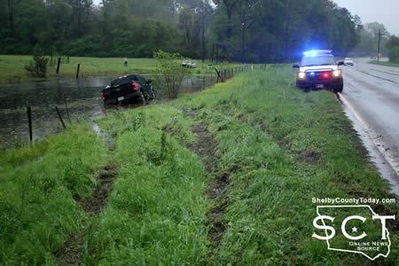
April 5, 2018 - A truck heading toward Shelbyville ended up in a pond just north of Shelbyville on State Highway 87 (SH87) Saturday, March 28, 2018.
According to Texas Department of Public Safety State Trooper Dustin Ramos, at 3:26pm a black 2016 Ford F150 driven by Courtney Greer, 38, of Shelbyville was southbound on SH87 at an unsafe speed for road conditions. The Ford hydroplaned and traveled off the roadway to the left where it struck a barbed wire fence with the front left distributed.
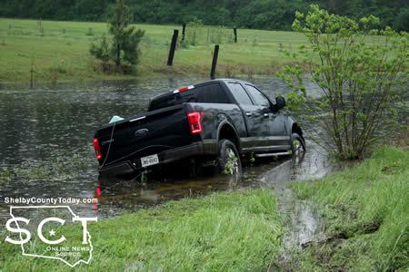
The Ford came to rest in a large body of water off the roadway, which partially flooded the front passenger compartment.
Greer was issued a citation for unsafe speed.
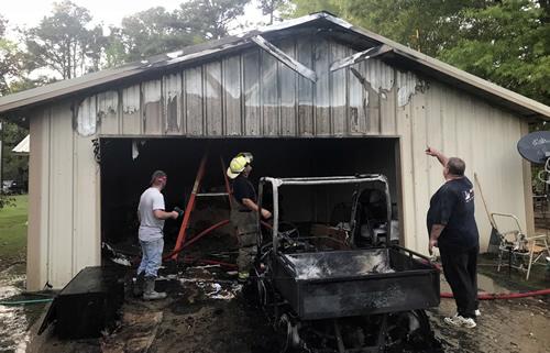
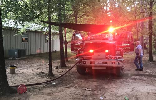
April 5, 2018 - On Wednesday evening, at approximately 6:16 p.m., the Joaquin Volunteer Fire Department was dispatched to a report of a structure fire at the corner of CR 3689 and CR 3853 in the Pine Ridge Community.
Fire units arrived to find a single story, wood frame metal sided home with heavy smoke showing from the attic above the garage. Firefighter’s attacked the fire through the attic access door in the garage and quickly extinguished the fire, limiting fire and smoke damage to the garage area. A side-by-side ATV parked outside the garage was completely destroyed.
After knocking the fire down, firefighters, with help from the homeowner, pulled the sheet rock ceiling down in the garage to ensure there was no hidden fire. The fire department returned to the station at 7:40 p.m.
4:30pm CDT, Tuesday, April 3, 2018
The National Weather Service in Shreveport has issued a Severe Thunderstorm Warning for Western Natchitoches Parish in northwestern Louisiana; Sabine Parish in northwestern Louisiana; Southeastern Nacogdoches County in eastern Texas; Southeastern Shelby County in eastern Texas; Eastern Angelina County in eastern Texas; San Augustine County in eastern Texas; and Sabine County in eastern Texas until 5:15pm CDT.
At 4:30pm CDT, severe thunderstorms were located along a line extending from near Patroon to 11 miles south of Macune, moving southeast at 45 mph.
HAZARD...60 mph wind gusts and quarter size hail.
SOURCE...Radar indicated.
IMPACT...Hail damage to vehicles is expected. Expect wind damage to roofs, siding, and trees.
Locations impacted include Milam, Many, San Augustine, Zwolle, Hemphill, Pineland, Patroon, Bland Lake, Neuville, Rosevine, Macune, Florien, Huxley, Noble, Fisher, Broaddus, Belmont, Bronson, McElroy and Yellowpine.
PRECAUTIONARY/PREPAREDNESS ACTIONS...
For your protection move to an interior room on the lowest floor of a building.
Pages