The story headline links to a better view of the story and share features.


News
February 10, 2018 - Alert: Crews are pretreating in Houston, Trinity, Nacogdoches, and Shelby counties today and Sunday for possible freezing precipitation.
More moisture is predicted with little or no accumulation. We will continue to monitor conditions.

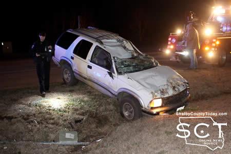
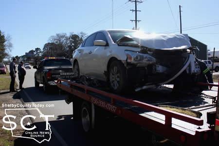
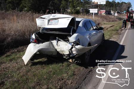
February 9, 2018 - State Highway 7 East was the scene of a two-vehicle crash in Center, Thursday, February 8, 2018 at Sardis Road.
When officers arrived, a white passenger car was on the eastbound shoulder and facing west. A white sport utility vehicle was on the westbound side of the roadway and flipped on its top.

ACE EMS personnel were also on scene to see to the medical needs of anyone involved in the crash.
According to Center Police Officer Angela Neal, at 7:15pm a white Dodge Neon driven by Jordan Shisler, 26, with passenger Raul Aquino Cortez, 23, both of Center was westbound on State Highway 7 and was stopped, preparing to turn.

As Shisler began turning onto Sardis Road, a white Chevrolet Trailblazer driven by Francisco Hernandez, 51, of Center approached from the rear and tried to pass on the shoulder, striking the right side of the Dodge. Hernandez lost control and the Trailblazer flipped onto its top in a ditch.
No injuries were reported as a result of the crash. Hernandez was issued a citation for no driver's license.


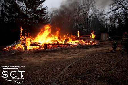
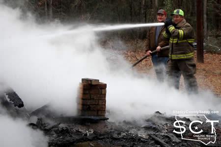
February 9, 2018 - East Liberty was the scene of a house fire 8:16am, Wednesday, February 9, 2018, and was a total loss for the residents.
When firemen arrived at the residence of Joseph Simpson on CR 2569, the house was fully engulfed in flames.

The house was too far along to be saved. Firemen worked quickly to extinguish the flames, and prevented further spread to the woods and homes nearby.
At the time of the fire, the cause was not immediately known. The heat from the fire caused damage to a vehicle on the property.


February 7, 2018 - The Tenaha City Marshal's Office has reported the arrest of three individuals involving two separate investigations.
 Tenaha City Marshal Jeremy Pope first reports on the result of the execution of a search warrant on February 5, 2018 in the city of Joaquin.
According to the press release, following a theft Investigation in the city limits of Tenaha, the Tenaha City Marshal's Office, on February 5, 2018, executed a search warrant at a residence located on East Saddle Street In Joaquin.
Officers with the Tenaha City Marshal's Office are reported to have located stolen property related to the theft along with an illegal firearm, narcotics and other dangerous drugs. A white female, identified as Elisha M. Remedies, 33, was taken into custody at the scene and transported to the Shelby County Jail, by the Tenaha Marshal's Office, and without incident.

Remedies was charged with Theft M(b), Unlawful Possession of a Firearm by a Felon F(3), Possession of a Controlled Substance M(a) and Possession of a Dangerous Drug M(a). This is an ongoing investigation with further arrests pending.
The Tenaha City Marshal's Office thanked the following agencies for their assistance In the county. Shelby County District Attorney's Office, Shelby County Constable Pct. 2, Texas Department of Public Safety and the Shelby County Probation Department.
In a separate investigation two more arrests occurred, according to City Marshal Pope. Following more information, on a theft that occurred in the city limits of Tenaha, on February 6, 2018, at approximately 8:30pm, officers with the Tenaha City Marshal's Office investigated a residence on West Drive in Tenaha.
 During the Investigation, a black male, identified as Bradley Brock, 27, was located inside the residence. Brock was taken into custody on a Tenaha warrant for Theft M (b). Brock was also arrested for Nacogdoches County warrants on three counts of Fail to Appear and one warrant for Bail Jumping.

During the Investigation, officers located marijuana inside the residence, which was located next to the Tenaha High School, Brock was also charged with Possession of Marijuana in a Drug Free Zone which is a State Jail Felony.

Also arrested at the residence was a white female, identified as Amy Allen, 37, Allen was charged with Possession of Marijuana in a Drug Free Zone, State Jail Felony. Both subjects were transported to the Shelby County Jail, by the Tenaha City Marshal's Office without Incident.
Marshal Jeremy H. Pope states, "This investigation Is still open, pending more arrests. The Tenaha Marshal's Office would like to thank the following agencies for their assistance in this investigation, Shelby County District Attorney's Office, The Department of Public Safety, Constable Pct. 2, Constable Pct. 4 and the Shelby County Probation Department."

February 7, 2018 - Timpson ISD Bear Update Alert
School Release
Due to illness, Timpson ISD will be closed Thursday and Friday, February 8th & 9th. School will also be closed Monday, February 12th.
Classes will resume on regular schedule Tuesday, February 13th. On the school calendar February 26th is indicated as a Remediation Day.
That day (Feb. 26th) will be a regular school day.
February 7, 2018 - The 2018 Primary Election Day draws near with March 6th now less than a month away. Early voting starts Tuesday, February 20 and runs through Friday, March 2nd. The last day to apply for a ballot by mail is Friday, February 23rd.
Shelby County has six local races unopposed which are James A. (Jim) Payne, Jr. (REP) for District Judge, 273rd Judicial District; incumbent Allison Harbison (REP,) County Judge; incumbent Lori Oliver (REP,) District Clerk; incumbent Jennifer Fountain (REP,) County Clerk; incumbent Jimmy Lout (REP,) County Commissioner PCT 2; and incumbent Marla Denby (REP,) Justice of the Peace PCT 2.
There are also six races with opponents:
- County Treasurer (2 Candidates) - Ann Blackwell (REP, Incumbent) and Donna Whitney (REP)
- County Commissioner PCT 4 (4 Candidates) - Bradley Allen (REP, Incumbent), Kevin Foster (REP), Sammy K Todd (REP), and Tom Bellmyer (REP)
- Justice of the Peace PCT 1 (3 Candidates) - Melissa Crouch (REP, Incumbent), Randy Robertson (REP), and Tommy Moody (REP)
- Justice of the Peace PCT 3 (3 Candidates) - Darrell Alford (REP), Deborah Sharp (REP), and Margie Anderson (REP, Incumbent)
- Justice of the Peace PCT 4 (2 Candidates) - Jackie Kirkwood (REP) and Jenny L. Hicks (DEM, Incumbent)
- Justice of the Peace PCT 5 (2 Candidates) - Tracy Broadway (REP) and Vernett Richardson (REP)
Almost all local elections will be decided during the March Primary as the majority of candidates filed with the Republican party. Only the race for Justice of the Peace PCT 4 had a Democratic candidate resulting in their matchup being in November.
Related articles:

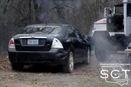
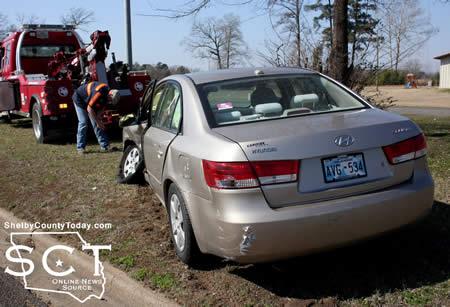
February 5, 2018 - Emergency personnel responded to the scene of a two-vehicle crash at U.S. Highway 59 just near U.S. Highway 84 in Timpson Monday, February, 5, 2018.
When first responders arrived, one vehicle was in the median on the northbound side of the roadway. Another vehicle was in the middle of a turning lane, also on the northbound side of the road.

According to Timpson Police Officer Michelle Ashworth, at 12:15pm a silver 2002 Toyota Camry driven by Veronica Farias-Prieto, 41, of Garrison with a 6-year-old female passenger was southbound on U.S. Highway 59 leaving Timpson.
At that time a tan 2008 Hyundai driven by Judith Beh Chiatoh, 31, of Louisiana exited from a private driveway at Woodland Christian Church and failed to yield right of way to the Toyota. As a result, the Toyota collided with the the front left of the Hyundai, causing major damage to both vehicles.
The Toyota circled through a turning lane through the median and came to rest on the northbound side. The Hyundai was knocked into the median where it traveled across and came to rest on the northbound side.
Timpson Volunteer Firemen arrived at the scene to direct traffic around the incident scene and assisted Timpson Volunteer Ambluance Service (TVAS) personnel.
Farias-Prieto was transported from the scene by TVAS to Nacogdoches Medical Center - Shelby Emergency Department for unknown minor injuries.
Beh Chiatoh was issued a citation for failure to yield right of way and Farias-Prieto was issued a citation for no driver's license.
February 5, 2018 - (New SWEPCO Texas Rates) - The Public Utility Commission of Texas (PUCT) has approved a base rate increase for Southwestern Electric Power Co. (SWEPCO), a unit of American Electric Power (NYSE: AEP).
The PUCT approved the increase in base rates to recover the costs of installing additional environmental controls at four major power plants, along with other generation, transmission, and distribution-related investments and operating costs.
The bill for a Texas residential customer using 1,000 kilowatt-hours (kWh) will increase approximately $8.59 per month, or 8.9 percent. This increase will begin with bills issued Feb. 5.
By Texas law, new rates are retroactive to May 20, 2017. A surcharge to collect the retroactive amounts will begin at a date to be determined by the PUCT. For residential customers, the surcharge is expected to be approximately $7.70 per month, or 7.9 percent, for an estimated 10 months.
“SWEPCO invested nearly $700 million in additional environmental controls so that four of our major power plants could meet stringent federal mandates,” said SWEPCO President and Chief Operating Officer Venita McCellon-Allen. “The retrofit projects were necessary for SWEPCO to continue providing reliable 24/7 power to our customers from a diverse energy resource mix,” McCellon-Allen said.
“We work hard to balance the need to make investments with the need to manage our costs because we recognize the impact that price increases can have on individuals, families and businesses,” McCellon-Allen said. “SWEPCO’s goal is always to serve Texas customers with a strong electric system that provides reliable, safe and affordable energy.”
SWEPCO completed major environmental retrofit projects at Welsh Power Plant Units 1 and 3 in Pittsburg, Texas; Pirkey Power Plant in Hallsville, Texas; Dolet Hills Power Plant in Mansfield, La.; and Flint Creek Power Plant in Gentry, Ark.
The PUCT decision, issued in a Jan. 11, 2018 final order, grants SWEPCO an annual base rate increase of $50 million.
Base rates refer to the costs of building, maintaining and operating SWEPCO’s electric system, including power plants, transmission and distribution lines, and facilities to serve customers. Base rates do not include the fuel portion of the customer’s bill, which pays for fuel and purchased power and is passed through to customers with no profit to the company.
SWEPCO serves 532,000 customers, including 184,300 in northeast Texas and the Texas Panhandle, 230,300 in northwest and central Louisiana, and 117,400 in western Arkansas. SWEPCO’s headquarters are in Shreveport, La. News releases and other information about SWEPCO can be found at SWEPCO.com. SWEPCO is an American Electric Power (AEP) company. AEP is one of the largest electric utilities in the United States, delivering electricity to nearly 5.4 million customers in 11 states.
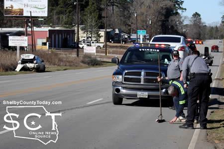
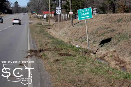
February 3, 2018 - DPS Troopers were dispatched to a two-vehicle crash on U.S. Highway 96 North just outside of Center at the intersection of FM 2026 (Folsom Chapel Road) January 22, 2018.
Previous to the arrival of Troopers, Shelby County Sheriff's Deputies arrived at the scene around 2:15pm to assist those involved and direct traffic around the vehicles involved.
According to DPS Trooper Taylor Buster, a white 2014 Nissan driven by April Calhoun, 39, of Center was stopped and preparing to turn left onto FM 2026 when a white Honda driven by Evette Bratchett, 35, of San Augustine approached from behind and collided with the rear of the Honda. Both vehicles received major damage.
The Nissan came to rest on the northbound side of the roadway and the Honda came to rest on the southbound side of the roadway.
Bratchett was issued citations for failure to control speed and no insurance.
February 2, 2018 - Center weather statistics for January, 2018 prepared and submitted by Ann Forbes, U.S. Weather Service Observer.
Highest Temp was 73 degrees on 1-21-2018
Highest Temp on Record was 85 degrees on 1-23-43 and 1-26-1950
Lowest Temp was 12 degrees on 1-17 and 1-18-2018
Lowest Temp on Record was 5 degrees on 1-19-1940 and 1-12-1982
Rainfall Recorded was 3.55 inches
Average Monthly Rainfall is 4.45 inches
Below Average by 0.90 inches
Highest Recorded for this Month was 12.13 inches in 1999
Lowest Recorded for this Month was 0.57 inches in 1986
17 days with temperatures of 32 degrees or below
One inch of Snow on 1-16-2018
Two Full Moons. One was a Super Blue Moon with Eclipse on 1-31-2018
Pages