

The story headline links to a better view of the story and share features.


News

April 24, 2026 - Severe Thunderstorm Watch 142 is in effect until 4am CDT April 25, 2026, for the following locations:
Texas counties included are Anderson, Bowie, Camp, Cass, Cherokee, Delta, Fannin, Franklin, Gregg, Harrison, Henderson, Hopkins, Huntsville, Lamar, Marion, Morris, Panola, Rains, Red Rover, Rusk, Shelby, Smith, Titus, Upshur, Van Zandt, Wood
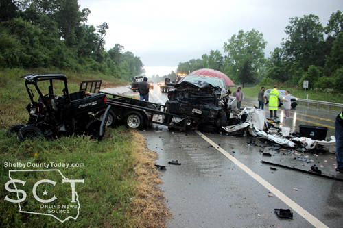
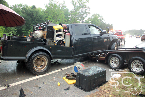
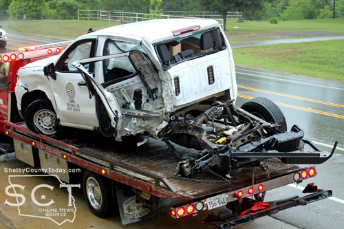
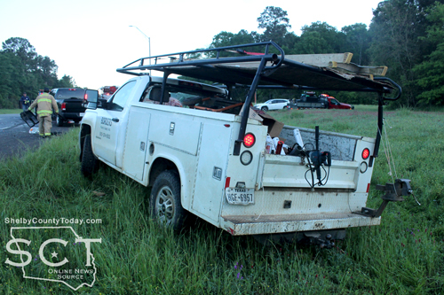
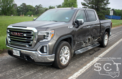
April 23, 2026 - U.S. Highway 96 South at the intersection of FM 417 was the scene of a two-vehicle crash incident Wednesday, April 22, 2026, during rainy conditions.
According to Texas Department of Public Safety State Trooper Josh Gradberg, sometime before 5:30pm a white 2025 Chevrolet pickup truck owned by CAPA, pulling a flatbed trailer, and driven by Christopher Miller of Bronson southbound at an unsafe speed hydroplaned into the northbound side of the roadway.
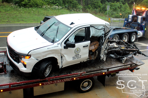
The truck and trailer traveled into the path of a black 2018 Dodge Ram pickup truck driven by James Martin of Center who was able to miss a head-on collision; however, the Ram still collided with the rear driver’s side of the Chevrolet.
Both vehicles came to rest in the northbound traffic lanes.
Miller was transported by private vehicle to Shelby Emergency Department for possible injuries.
Martin was not reported to have been injured.

Miller was also issued a citation for unsafe speed.
Trooper Gradberg was assisted at the scene by Trooper Ashley Hughes.

April 23, 2026 - (Update): Commissioner McSwain reports that after extensive rain yesterday, CR 1005 will be closed from Mill Creek to the intersection of CR 1024 until further notice!

April 22, 2026 - During the course of April 20-21, CR 1005 has been closed during the hours of 8am and 3pm to allow for school bus and mail traffic to run normally.
Commissioner Roscoe McSwain reports that the Precinct 1 Road and Bridge crew is handling a major project due to the storm of 2024, which caused a lot of damage to that road and a 60-foot long headwall. Three new culverts have been added to the road so that it could be worked on to redo the road completely and alter the water flow.
McSwain stated that when work begins on the headwall an outside contractor will be called in to help with the project. Commissioner McSwain commented that Stevie Smith, Precinct 2 Commissioner, was helpful in supplying a track hoe from Precinct 3 to help quickly install the three culverts.
The work crew is now building up the roadway, and Commissioner McSwain added that once they begin work on the headwall, the roadway will likely be closed for a week to 10 days. McSwain described a great deal of dirt work that will have to be completed to work on the headwall.
According to McSwain, FEMA had approved the project at a cost of $80,000; however, he indicated that after two years the county is still awaiting payment from FEMA for work already completed. He decided for Precinct 1 to absorb the cost at $30,000 to $40,000 instead of adhering to a more expensive design which might not be compensated.
Commissioner McSwain commented that FEMA already owes Precinct 1 $253,000, which has impacted his budget over the past two years. He said he's recovering now due to being very frugal and not spending much money.
It will be inconvenient for school buses and mail carriers who both use that route. Commissioner McSwain can't wait until school is out, because his precinct will then be making oil sand.
Residents should be prepared for future road closure notification on CR 1005 as the project begins on the headwall.
April 21, 2026 - Commissioner McSwain reports CR 1005 will remain closed Wednesday, April 22, 2026 from 8am until 3pm for continued repair work.
This article is copied from Shelby County Today without permission.
April 20, 2026 - Roscoe McSwain, Commissioner Precinct 1, reports that County Road 1005 at Mill Creek to the intersection of County Road 1024 will be closed Tuesday, April 21, from 8am till 3pm.
This article is copied from Shelby County Today without permission.
Drivers should plan an alternate route during this time until the roadway is back open.
April 21, 2026 - The Shelby County Commissioners were locked into an almost two-hour executive session with district judges, and prosecutors during their Wednesday, April 15, 2026 meeting.
The commissioners’ court went into executive session shortly after 10am and discussions continued there with Jim Payne, 273rd Judicial District Judge; LeAnn Kay Rafferty, 123rd Judicial District Judge; Karren Price, 123rd Judicial District Attorney; and John Price, County Attorney until the executive session released at 11:49am.
When court returned to open session, County Judge Allison Harbison advised that no action would be taken on what had been discussed during executive session and that items related to what was discussed would be placed on the April 22 meeting agenda.
As reflected in the April 22 meeting agenda, the court intends to discuss a new hourly rate of pay for the 273rd Court Coordinator and the resignation of the 123rd Court Coordinator, as well as approve the hiring of a new Court Coordinator at the current budgeted rate.

Shelby County Sheriff's Department Chief Deputy Mike Hanson presented the court with a request to purchase WatchGuard in-car and body camera equipment from Center Police Department in the amount of $3,625 to be paid from Senate Bill 22 funds.
Included in the purchase would be 16 body cameras, nine single chargers that can go in vehicles or elsewhere, one multi-bay charger that holds around 10 body cameras, 16 uniform clips, and then seven in-car systems.
"Center Police Department has recently went to a new camera system (AXON) both in their cars and for their body camera uses," said Chief Hanson.
Chief Hanson explained the video equipment currently used by the Sheriff's Department primarily is WatchGuard, and he believes one patrol vehicle has a Digital Ally system in it acquired from another agency.
"These camera systems are, they're really outdated. Motorola absorbed WatchGuard some years ago. The systems that we've got, we've got some issues," said Chief Hanson. "They had seven in-car camera systems. Some of that would be used to, this is a band-aid at best, but they would be used to fix some of the camera systems that we've got now."
According to Chief Hanson, one of the cameras they have been using will randomly turn off during a shift without any indication why, or that it has shut off.
Through the acquisition of the equipment from the Center Police Department, Chief Hanson explained parts would be used to hopefully repair current systems.
As Chief Hanson explained, camera systems prove to be very cost prohibitive in general.
"Right after we got there with the new trucks that were purchased, three of them were going to be marked and they were going to have cameras installed. I priced cameras from multiple companies at that time for those three trucks alone, with body cameras, and it was anywhere from $28,000 to $35,000 for three cameras," said Hanson.
The system the Sheriff's Department uses requires the removal of the memory stick from the system and a download be initiated to an external hard drive in a dedicated computer.
Newer systems, like the Center Police Department has, have cloud-based storage that automatically uploads. According to Chief Hanson, that system is in the $130,000 price range.
Commissioner Tom Bellmyer moved to approve purchase of the equipment. Commissioner Shannon Metcalf seconded the motion and it carried with all in favor.
Chief Hanson spoke to the commissioners about the purchase of a ballistic vest from Center Police Department in the amount of $900 to be paid from Senate Bill 22 funds.
"As the ballistic panels, all of the vests that were [at the Sheriff's Department] when we arrived were either expired, or they expired last year," said Hanson. "We've had to purchase new vests and going through the rep, it's going to be the same rep that Center PD had used."
According to Chief Hanson, when we were sizing ballistic vests for Sheriff's Department deputies, the rep encouraged them to contact the Center Police Department about one of the vests they have because the officer fitted for that vest works at the Sheriff's Department now.
"The vests are about $1,300 a piece. I talked to Center PD they allowed him, he's worked for us for some time now, but they allowed him to use that vest once he come over to our agency, but they priced it at $900. They have a five-year use life once they go into service and his I believe it's less than a year," said Chief Hanson.
Once again, Chief Hanson reiterated the purchase of the vest is a "band-aid" and not the solution yet. He said they hope to address several issues regarding equipment in the coming budget and with Senate Bill 22.
Teresa Hughes, County Auditor, stated that if the purchases are approved during the meeting the Senate Bill 22 money available for the remainder of the budget year would be $35,500.
Commissioner Bellmyer moved to approve the purchase of the vest. Commissioner Stevie Smith seconded the motion and it carried with all in favor.

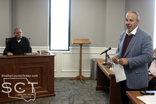
The commissioners were presented with a request to close a portion of CR 1512 by Jeff Davis, who happens to be the 145th Judicial District Judge in Nacogdoches County, and he was accompanied by his brother Brian.
Davis made the request with the understanding they would provide an area for the county to be able to turn around a maintainer. Also, that if anybody went down that road they'd be able to turn around safely and return to 1510 which is the main road that goes across the big dam.
Commissioner Roscoe McSwain moved to allow the closure of that portion of CR 1512. His motion was was seconded by Commissioner Shannon Metcalf, and it carried with all in favor.
The meeting adjourned at 11:53am.
Agenda items approved during the meeting include:
1. Pay weekly expenses.

2. Close a portion of County Road 1512 located in Shelby County, Texas; which portion has been surveyed with such survey and plat being attached to the written request to close.

3. Sheriff’s Department  to purchase WatchGuard in-car and body camera equipment from Center PD in the amount of $3,625 to be paid from SB22 funds.

4. Sheriff’s Department to purchase a ballistic vest from Center PD in the amount of $900 to be paid from SB22 funds.

5. Adjourn at 11:53am.
Center Volunteer Fire Department Notable Events Summary
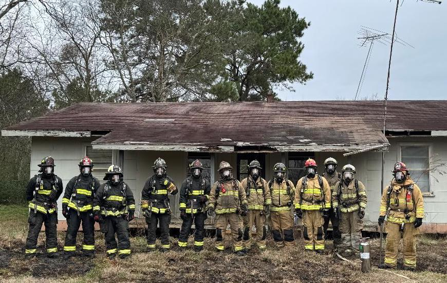
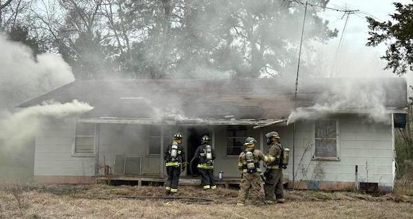
April 21, 2026 - Over the past several months, the Center Volunteer Fire Department (VFD) has participated in a variety of notable events that highlight the department’s continued commitment to training, leadership, and service to the community.
This article is copied from Shelby County Today without permission.
On February 21, the Center Volunteer Fire Department participated in a combined training exercise with the Shelbyville Volunteer Fire Department. During this training, personnel were able to utilize an acquired structure generously donated by Zack Mahan. This opportunity provided realistic, hands-on experience in critical fireground operations, including search and rescue, forcible entry, and fire suppression tactics. At the conclusion of the training, the structure was safely burned under controlled conditions, allowing crews to further enhance their operational readiness while maintaining scene safety.

In March, the Center Volunteer Fire Department conducted its annual officer elections. The results are as follows:
Volunteer Fire Chief – Del Birdwell
1st Assistant Chief – Luke Mooney
2nd Assistant Chief – Jason Burch
Secretary/Treasurer – Kaden LaRock
Training Officer – Luke Fausett
Chaplain – Joshua Eddins
As always, the members of the Center Volunteer Fire Department remain dedicated to serving the citizens of Center and the surrounding areas with professionalism, training, and a commitment to excellence.
April 20, 2026 - The Shelby County Commissioners learned of a new feature to alert taxpayers of delinquencies via text message during their meeting held April 8, 2026.
Kevin Dutton, representative of Linebarger, Goggan, Blair, and Samson LLP, provided details to the commissioners on text message notifications to individuals regarding delinquent taxes.
“The legislature enabled text message collecting for delinquent taxes, and there are several reasons that they've done that. One, everybody lives on their phone very few people even have home landlines now so when we skip trace we'll get these landline numbers but nobody answers,” said Dutton.
Dutton stated most people get all their mail that they think is relevant by email, which results in a lot of return mail or unanswered mail on tax collections. He said that doesn’t mean there isn’t good response from their mailings, and they will continue to send normal mailings.
“This went into effect September the 1st, [2025]. We've got our technology now where we can start doing that. And so we're going around and asking the tax collectors for their permission to do it,
which is all we really have to have,” said Dutton. “We don't have to have the commissioners’ court, but she wanted me to give y'all the information before she pulled the trigger.”
Dutton elaborated on the common use of smart phones among the public and the extensive reliance on texting as a means of communication.
“Everybody communicates that way. We found that text messages get more looked at than people opening mail. They'll open it and look at it, and so we decided we were going to do that,” said Dutton.
“Scammers” were considered when preparing the system for text communication and Dutton said that they devised the use of a short-code that displays as five digits at the top of the recipients text message to indicate that it’s real, as well as Linebarger, Goggan, Blair and Sampson branding at the bottom of the message.
“What you'll notice about scams also is they don't have branding. We will have the Linebarger brand down at the bottom of ours. We'll have a link for them to make a payment. We'll have a toll-free callback phone number that they can call and ask questions,” said Dutton. “We’ll also have their account number, so they can click on that and see what we're referring to.”
Dutton explained that attempts are being made to prevent people from being scammed.
“I will tell you, we've ran tests in Smith County that have been highly successful. I don't have the numbers on that yet because it hasn't gotten to me. I do know that we tried it in Van Zandt County three weeks ago and started it. Not tried it, but we started it. We sent out text messages on Monday, on Tuesday, three accounts that we had no contact with by mail or by telephone paid online. So people are going to respond to this.” said Dutton.
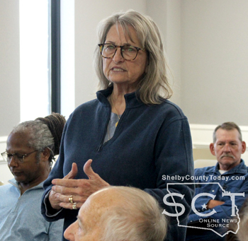
Debora Riley, Shelby County Tax-Assessor Collector, said that she has shared information on the Tax Assessor-Collector website about the text notification program. She noted there may be some hesitancy on the part of recipients to even open the text message and she advised they don’t even have to open the message.
“If they receive a text, they don't want to open it, that's fine, it just lets them know that they might need to go check out our online and see if they owe anything or give us a call and we'll be glad to go ahead and look that up for them so they don't actually have to open the text message if they get it,” said Riley.
Riley had a question of her own involving miscommunication, in the event a recipient has no connection to the property involved and they want their number removed.
“There is a toll free number on there that's on the actual text message itself that they can call and make those corrections. Evidently they can text back because we've received some, I’m not going to say them in court, but we've received some ugly text messages,” said Dutton.
Dutton described the cost difference of a text message being three cents to the cost of 85 cents to a dollar utilizing the United States Postal Service. Riley and Dutton clarified for the court that these messages won’t go out this year until July 2026, should they be delinquent.
“Like right now, they have their mailings, I think they had a mailing go out in February, and it didn't include the 2025s because they never include the current year until that first mailing that they do in July,” said Riley. “So that's kind of confusing for people, too, because they see their statement and they think that's everything they owe and they don't realize they owe for the current year. We have that happen a lot.”
No action was necessary to to be taken by the commissioners as the discussion was informational only. The commissioners sounded as though they were in favor of the endeavor.
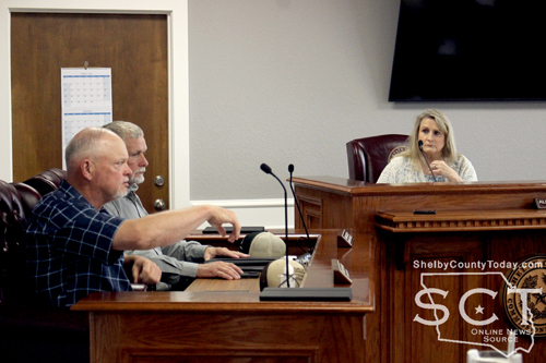
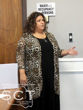
Karren Price, 123rd Judicial District Attorney, presented the court with the SART (Sexual Assault Response Team) report and she introduced Emma Skinner with the Family Crisis Center in Nacogdoches and Price said she is also their interface with the governor’s office.
“In 2021, the legislature mandated every county create or formulate a SART team, sexual assault response team. It works exactly the same as the Children's Advocacy Center MDT (Multidisciplinary) teams meet, so we have a number of people from around the county the legislature set out exactly who is supposed to be on that team. We are now meeting quarterly y'all may remember we formed it in December of ’22,” said Price.
Price informed the court that in 2026 they have had their first mandated report to the governor's office. Although, the reporting was a little late due to new legislation enacted in 2025, Price explained that Skinner was able to help resolve that late entry as a result of her interface with the governor’s office.
“The goal of the teams is to increase reporting, because we are under reporting in that area of crime,” said Price. “We need to get better at not only encouraging young men and women who are sexually assaulted to come forward, tell us about that so that we can help you get out of that situation.”
Price described a case pending on the court docket right now that occurred in 2025, and she said she doesn’t know how the woman involved survived. By Price’s estimation, and she said by the estimation of medical staff, the woman should not have survived.
“So those things happen in our own backyards, and I know that you all are as devastated to hear that, as I am to report it,” said Price. “Hopefully the formation, and the regular quarterly meetings of a team that's dedicated to thinking about making people understand how important it is for us to report it, so that we can prosecute those cases. It's been a long time since we actually prosecuted a sexual assault of an adult in Shelby County and we need to be better and we're gonna be better.”

Skinner explained for the court that the purpose of a SART is to support adult survivors of sexual assault and increase community collaboration. Skinner says this helps survivors heal faster when they have that support from law enforcement, the DA’s office, advocates, and local nurses.
“They are more likely to come forward and report if they know that they will have a listening ear and have support afterwards, and they're also more likely to participate in the prosecution process,” said Skinner. “These cases are more likely to go to court and get justice, and put that bad guy away when those survivors know that they have a whole team behind them.”
Skinner highlighted Shelby County is fortunate to have a District Attorney that cares about supporting survivors of sexual assault, as well as the support of law enforcement.
“So this community collaboration really, it doesn't happen by accident. It takes a DA who cares, it takes law enforcement who wants to show up. It's a chance for all of us to just get in the room together and discuss these cases, discuss the changes in the law and make sure that we are all providing services and support in the most trauma-informed way,” said Skinner.
Skinner shared that data was prepared to send to the state, and should bring them into compliance; however, the SART must have the endorsement of the court to move forward to allow them to meet regularly.
“That's really why we're here, just to get y'all on board, hopefully. I really believe in SARTs. We do this in five other counties where I help facilitate and kind of do the admin work. It's really y'all's county that will benefit from this and we're excited about that. This really does work in other counties as well. It's been shown to increase reporting and also increase prosecutions of these cases,” said Skinner.
Commissioner Tom Bellmyer moved to approve the SART report, and Commissioner Stevie Smith seconded his motion. It carried with all in favor.
The commissioners were presented with a quote for $34,550 from Cornerstone Construction project involving the courthouse parking areas. The project began with tree removal.
Commissioner Roscoe McSwain anticipated some discomfort at the courthouse while the project was ongoing, but he felt that the bid was fair.
Commissioner McSwain moved to go forward with the project and approve the contract of $34,550 to be taken out of the courthouse repairs fund. Commissioner Smith seconded his motion and it carried with all in favor.
The meeting adjourned at 10:09am.
Agenda items approved during the meeting include:

1. Minutes of: March 4th Special Meeting, March 11th Regular Meeting, March 18th Special Meeting and March 25th Special Meeting.
2. Pay weekly expenses.
3. Pay current payroll.
4. Officers Report.
5. Lift the burn ban that was put in place on March 27.
6. Linebarger, Goggan, Blair & Sampson LLP, to discuss text message alerts for resolving delinquent accounts.
7. SART Report.
8. Quote from Cornerstone Construction for the upgrades to the Courthouse parking areas in the amount of $34,550.
9. Adjourn at 10:09am.
March 30, 2026 - The May Uniform Election Day for local non-county political subdivisions such as cities and schools is Saturday, May 2, 2026.
The entities hosting an election May 2nd are: City of Tenaha, City of Timpson, Shelbyville ISD, and Timpson ISD.
Upcoming calendar dates to note are listed below.
- Last day to register to vote or update your voter registration is April 2.
- Early Voting is April 20 - 28, 2026. Note: No weekend voting and no voting on San Jacinto Day (April 21st).
- Election day is May 2, 2026

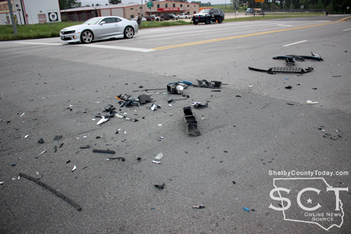
April 19, 2026 - State Loop 500 at the intersection of Farm-to-Market 699 was the scene of a major crash incident early on the morning of Wednesday, April 8, 2026.
Emergency responders were dispatched to the location of the incident and found both vehicles involved to be on the eastern side of the roadway with one on the shoulders and the other further off the roadway in a ditch.
Center Fire Department personnel and Shelby County Sheriff's deputies diverted traffic while Texas Department of Public Safety State Troopers investigated.

According to the Texas Department of Public Safety, the preliminary crash investigation indicates that at approximately 6:39am, a black 2018 Dodge Ram 1500 driven by Anthony Flemings, 60, of Center was traveling east on F.M. 699 approaching the intersection of S.L. 500, while a white 2015 Dodge Ram 1500 driven by Primitivo Reyna, 59, of Chicago, IL. was traveling east on S.L. 500. It is reported that Flemings disregarded the stop sign at the intersection and struck the 2015 Dodge.
Flemings was transported to the Shelby Emergency Department for treatment of non-life-threatening injuries and is being charged for driving while intoxicated, a misdemeanor offense, pending results.
Reyna was transported to Shelby Emergency Department of Center for treatment of non-life-threatening injuries.
Investigating the crash were Trooper Keith Jones assisted by Trooper Ashley Hughes.
Center Police Department officers also assisted at the scene.
According to DPS, this is an ongoing investigation, and no further information is available at this time.
April 17, 2026 - The U.S. Attorney’s office has reported the sentencing of a Houston man to Federal prison for his involvement in a “Hook and Chain” crime spree in at least two states.
According to details in a press release Cody “break da bank cobo” Williams, 27, pleaded guilty to conspiracy to commit bank theft and was sentenced to 60 months in federal prison by U.S. District Judge Sean D. Jordan on April 15, 2026. Williams was ordered to pay restitution in the amount of $71,639.
According to court documents, from June 2020 to June 2024, Williams was involved in a crime spree referred to as “Hook and Chain” burglaries, which involved stealing a truck, attaching hooks and chains to the vehicle, and using it to drag the door off an ATM to retrieve the cash currency from the machine. This crime spree involved several burglaries in Texas and Arizona, including the Texas Bank on South Preston Road in Prosper. The conspiracy resulted in a loss of over $400,000 in bank funds and damage to property.
Shelby County was the target of similar incidents during the same time period and law enforcement suspected the ATM thefts were well organized by a large group of individuals from the Houston area. In October 2020, thieves made an attempt at a “hook and chain” operation at the Shelby Savings Bank on Selma Street in Center when Center Police Officers interrupted that attempt and apprehended suspects Robert Washington, Jr. and Paul Benjamin Madison.
In November 2020, an ATM at Citizens Bank on Austin Street in Center was the target of a “hook and chain” involving a red 2000 Ford F-350 with a chain which was later located at a car dealership nearby. It wasn’t reported at that time if those involved were successful in obtaining any funds from the machine.
According to Shelby County court documents, cases against Madison which included two counts of engaging in organized criminal activity that were dismissed in consideration of convictions in Harris and Cass Counties for other crimes. He was sentenced to 10 years in the Texas Department of Criminal Justice Inmate Division, and is eligible for parole as of January 2025. Otherwise, his projected release date is September 2030.
Madison was sentenced to 10 years in Harris County for theft of property <$300K ATM; and aggravated robbery. In Cass County he was sentenced to five years for two counts of engaging in organized criminal activity.
Washington’s Shelby County case of engaging in organized criminal activity remains open as of April 2026; however, it is listed as being placed on inactive status and hasn’t had any new entries since August 2023 when his attorney withdrew as counsel.
According to the U.S. Attorney's Office, the case against Williams was investigated by the FBI, Fort Worth Police Department, and Pottsboro Police Department and was prosecuted by Assistant U.S. Attorney Matthew T. Johnson.
Related articles:

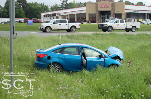
April 16, 2026 - State Loop 500 and U.S. Highway 96 South was the scene of a two-vehicle crash incident Wednesday, April 15, 2026.
When officers arrived, one vehicle involved was located in a ditch and the other vehicle had come to rest on the southbound side of U.S. 96.
According to the Center Police Department, at 8am a blue 2015 Ford Focus Titanium passenger car driven by Arnyrice Wallace, 22, of Louisiana was westbound on SL 500. The Ford entered the intersection at a green light and a brown 2019 GMC pickup truck driven by Guadalupe Arguello, 44, of Center was southbound on U.S. Highway 96 when it ran a red light traveling into the intersection, striking the Ford.
The Ford came to rest on the southeastern corner of the intersection. The GMC came to a stop on the southbound shoulder of U.S. 96.
Wallace was transported by ambulance to Shelby Emergency Department for treatment of possible injuries.
No citations were reported to have been issued.
Texas Department of Public Safety State Troopers assisted at the scene.
Pages