

The story headline links to a better view of the story and share features.


News
June 4, 2026 - Emergency responders were dispatched to the intersection of U.S. Highway 59 and U.S. Highway 84 on Wednesday, June 3, 2026, for a two-vehicle crash involving a truck tractor and a passenger car at around 8:20am.
According to the Texas Department of Public Safety (DPS), a white 2023 Infiniti QX60 driven by Melaney Morris, 66, of Lufkin was stopped at the sign on U.S. 84 waiting to cross U.S. 59. A two-tone blue and white 2012 Peterbilt driven by Dominique Emerson, 35, of Shreveport, La. towing a bobtail trailer was traveling south on U.S. 59. It is reported that the Infiniti failed to yield the right-of-way at the stop sign, attempted to cross U.S. 59, and was struck by the Peterbilt.
Morris, and one passenger Nancee Bennett, 65, of Lufkin were not injured. Emerson was also not injured.
DPS did not provide citation data at the time of this report.
According to DPS, this is an ongoing investigation, and no further information is available at this time.
The crash was investigated by DPS Trooper Jordan Ford. Timpson Volunteer Fire Department assisted at the scene of the crash.
According to TxDOT crash report data, there have been 21 crash incidents recorded in the vicinity of the intersection involved in the past four years. Four of those reported crashes occurred in 2025 and five are reported to have occurred in 2026.

Update: National Weather Service Shreveport LA issued a Severe Thunderstorm Warning at 4:13pm for Northwestern Sabine Parish in northwestern Louisiana, Angelina County in eastern Texas, Nacogdoches County in eastern Texas, Northwestern Sabine County in eastern Texas, San Augustine County in eastern Texas, Shelby County in eastern Texas, and Southeastern Cherokee County in northeastern Texas until 5:15pm.
At 413 PM CDT, severe thunderstorms were located along a line from over Shelbyville to 12 miles southwest of Forest, or along a line from 6 miles southeast of Center to 25 miles south of Rusk, moving southeast at 20 mph.
Radar indicated 60 mph wind gusts and quarter size hail. Impact includes hail damage to vehicles is expected and expect wind damage to roofs, siding, and trees.
Update: At 4:05pm a line of strong thunderstorms will impact Nacogdoches, Northwestern Angelina, Southeastern Cherokee, Northern San Augustine, and Central Shelby Counties until 5pm.
At 4:05pm, Doppler radar was tracking a line of strong thunderstorms extending from over Shelbyville to 8 miles southwest of Morrill, or extending from 5 miles east of Center to 18 miles south of Rusk, moving south at 15 mph.
June 2, 2026 - The National Weather Service in Shreveport has issued a Severe Thunderstorm Warning for Southern De Soto Parish in northwestern Louisiana, Northwestern Natchitoches Parish in northwestern Louisiana, Central Red River Parish in northwestern Louisiana, Northwestern Sabine Parish in northwestern Louisiana, Eastern Shelby County in eastern Texas until 4:45pm CDT.
At 3:40pm CDT, severe thunderstorms were located along a line from 5 miles east of Coushatta to over Logansport, or along a line from 22 miles northwest of Natchitoches to 14 miles northeast of Center, moving south at 20 mph.
Hazard: 60 mph wind gusts and quarter size hail.
Source: Radar indicated.
Impact: Hail damage to vehicles is expected. Expect wind damage to roofs, siding, and trees.
Locations impacted include: Mansfield, Coushatta, Logansport, Campti, Joaquin, Converse, Patroon, Allen, Oak Grove, Pleasant Hill, Martin, Huxley, South Mansfield, Noble, Edgefield, Powhatan, Stanley, Pelican and Rambin.
Instruction: Seek shelter inside a well-built structure and stay away from windows. These storms are capable of producing damaging winds and large hail.
A line of strong thunderstorms will impact northeastern Nacogdoches, southeastern Panola, northwestern San Augustine and Shelby counties and southwestern De Soto parish until 4pm CDT.
At 3:24pm CDT, Doppler radar was tracking a line of strong thunderstorms extending from over Joaquin to over Timpson, or extending from 12 miles northeast of Center to 14 miles northwest of Center, moving south at 20 mph.
Hazard: Wind gusts up to 50 mph and half inch size hail.
Source: Radar indicated.
Impact: Gusty winds could knock down tree limbs and blow around unsecured objects. Minor damage to outdoor objects is possible.
Locations impacted include: Center, Logansport, Tenaha, Timpson, Joaquin, Shelbyville, Neuville, Patroon, Martinsville, Jericho, James, Arcadia, Paxton, Calgary, Stockman, Hurstown and Jordans Store.
Precautionary/Preparedness Actions: Monitor the weather situation closely and be alert for threatening weather conditions.
If on or near Toledo Bend Texas side, get out of the water and move indoors or inside a vehicle. Remember, lightning can strike out to 10 miles from the parent thunderstorm. If you can hear thunder, you are close enough to be struck by lightning. Move to safe shelter now! Do not be caught on the water in a thunderstorm.
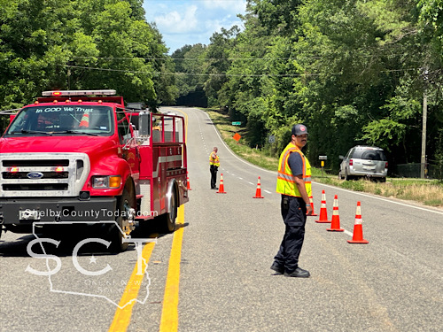
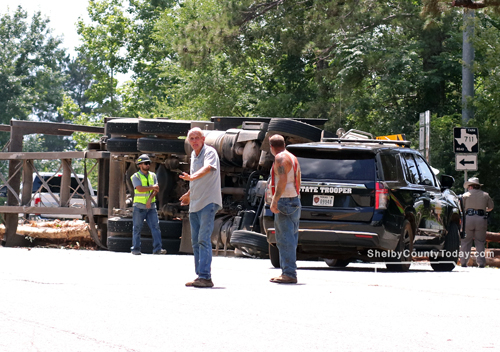
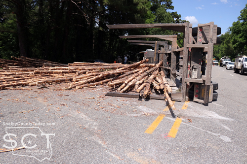
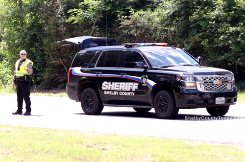
June 1, 2026 - State Highway 7 West at FM 711 was the scene of a truck tractor rollover Monday, June 1, 2026 as of 3:13pm. Traffic is blocked on the westbound side of the roadway. Traffic control by Center Fire Department and Shelby County Sheriff’s Department deputies was underway while Texas Department of Public Safety State Troopers investigated.

According to Texas Department of Public Safety State Trooper Colton Bearden, a white 2015 Mack truck owned by AB Services and driven by Henry Stevens, 55, of Nacogdoches out of Center was hauling a load of logs northbound on FM 711. Stevens disregarded the stop sign at the intersection of State Highway 7 West and the truck and trailer turned over and lost its load.
No injuries were reported to have resulted from the crash.
Stevens was issued a citations for disregard stop sign.
Richard Tomlin happened to be in the vicinity when the incident occurred. He assisted with traffic control and used a track hoe to lift debris to help Hopkins Wrecker Sevice right the truck tractor.
The roadway was cleared at 4:45pm.


May 31, 2026 - A Shelby County Grand Jury delivered 25 indictments on Thursday, May 28, 2026. The grand jury was impaneled for the January 2026 term of the 273rd Judicial District Court.
Arturo Gonzalez was indicted for intoxication assault, third degree felony. The indictment alleges, on June 1, 2025, Gonzalez operated a motor vehicle in a public place while intoxicated, and by reason of such intoxication caused serious bodily injury to another, namely Da Pra, by accident or mistake in crossing the center line and median striking the victim's vehicle head-on. (123rd Judicial District Court)
Brad Ernest Smith was indicted for assault family violence - enhanced, third degree felony. The indictment alleges, on February 11, 2026, Smith recklessly caused bodily injury to Dusty Davis, a member of Smith's family as described by the Texas Family Code - Section 71.003, by striking Davis in the face with his fist. The indictment further shows Smith was previously convicted in Orange County in 2006 for an offense under Chapter 22 of the Texas Penal Code against a family member as described by the Texas Family Code - Section 71.003. (123rd Judicial District Court)
Gregory Lemond Harper was indicted for terroristic threat against peace officer/judge, state jail felony. The indictment alleges, on April 30, 2026, Harper threatened to commit an offense involving violence to a person, namely murder, aggravated assault or assault, with intent to place Andrew Williams in fear of imminent serious bodily injury. The indictment further indicates [Lt.] Andrew Williams to be a peace officer employed bu the Center Police Department. (273rd Judicial District Court)
Ramiro Reyes was indicted for evading arrest with a motor vehicle, third degree felony. The indictment alleges, on March 3, 2026, Reyes used a vehicle to intentionally flee from Center Police [Sgt.] Brian Wright, a person Reyes knew was a peace officer who was attempting to lawfully arrest or detain Reyes. (123rd Judicial District Court)
Kentrell Cortez Claiborne was indicted for unlawful possession of a firearm by felon, third degree felony. The indictment alleges, on December 15, 2025, after having been previously convicted in 2001 of the Felony offense of unlawful restraint less than 17 years of age, Claiborne recklessly possessed a firearm after the fifth anniversary of his release from confinement following conviction for the previous felony. It is further alleged that Claiborne possessed the firearm on State Highway 7, which was a location other than the premises at which he lived. (273rd Judicial District Court)
Charles Seth Alexander was indicted for theft of property >=$30,000 but less than $150,000, third degree felony. The indictment alleges, on January 31, 2026, Alexander took a 2019 Kubota tractor valued at $30,000 or more but less than $150,000 from Hoffpauir Tree Service Inc., the owner. It is further alleged this was done without consent of the owner and with intent to deprive the owner of the property. (273rd Judicial District Court)
Clayton Russell was indicted for theft of property >=$30,000 but less than $150,000, third degree felony. The indictment alleges, on January 31, 2026, Alexander took a 2019 Kubota tractor valued at $30,000 or more but less than $150,000 from Hoffpauir Tree Service Inc., the owner. It is further alleged this was done without consent of the owner and with intent to deprive the owner of the property. (123rd Judicial District Court)
Alan Jay Runnels was indicted for unlawful possession of firearm by felon, third degree felony. The indictment alleges, on April 6, 2026, recklessly possessed a firearm before the fifth anniversary of his release from supervision under parole or mandatory supervision following pervious conviction of prohibited substance in a correctional facility on July 12, 2029 in Gregg County. (123rd Judicial District Court)
(Some of the following content contained within indictments is of a sensitive nature and may not be suitable for younger viewers.)
Sabrina Lynn Parent was indicted for sexual assault, second degree felony. The indictment alleges, on June 7, 2025, Parent caused the sexual organ of a child who was then and there younger than 17 years of age to contact and penetrate the sexual organ of Parent. (123rd Judicial District Court)
(Dates in parenthesis indicate the date of the alleged incident):
- John David Farnell, possession of a controlled substance PG1/1-B >=1G<4G (methamphetamine), third degree felony (June 11, 2025). (273rd Judicial District Court)
- Kurt Glenn Russell, driving while intoxicated - 3rd or more, third degree felony (Punishment Enhancement - 25 years to life) (February 23, 2025). (123rd Judicial District Court)
- Tracy Denard Osby, driving while intoxicated - 3rd or more, third degree felony (Punishment Enhancement - 25 years to life) (January 23, 2026). (273rd Judicial District Court)
- Danny Brown, felony driving while intoxicated, third degree felony. (January 21, 2026) (273rd Judicial District Court)
- Orell Parker, Jr., driving while intoxicated - 3rd or more, third degree felony (Punishment Enhancement - 2nd degree felony) (January 12, 2026). (123rd Judicial District Court)
- Kevin Dwayne King, manufacture or delivery of substance - PG1 >=4G<200G (methamphetamine), first degree felony (Punishment Enhancement - 15 years to life) (August 20, 2025). (123rd Judicial District Court),
- Marquis Deon Reed, possession of a controlled substance PG1/1-B >=1G<4G (methamphetamine), third degree felony (Punishment Enhancement - 25 years to life) (July 18, 2025). (273rd Judicial District Court)
- Mitchell Carroll Permenter, possession of a controlled substance PG1/1-B <1G (methamphetamine), state jail felony (February 8, 2026). (273rd Judicial District Court)
- Derek Clinton Ward, possession of a controlled substance PG1/1-B <1G (methamphetamine), state jail felony (Punishment Enhancement - 2nd degree) (January 15, 2026). (123rd Judicial District Court)
- Mateo Garcia, possession of a controlled substance PG1/1-B <1G (methamphetamine), state jail felony (December 21, 2025). (273rd Judicial District Court)
- John Leo Etheridge, driving while intoxicated - 3rd or more, third degree felony (Punishment Enhancement - 25 years to life) (July 16, 2025). (123rd Judicial District Court)
- Armando Olivera Santos, driving while intoxicated - 3rd or more, third degree felony (March 2, 2025). (273rd Judicial District Court)
- Bianca Betty Vazquez, possession of a controlled substance PG1/1-B <1G (methamphetamine), state jail felony (March 7, 2026). (123rd Judicial District Court)
- Jerry Bell, possession of a controlled substance PG1/1-B <1G (methamphetamine), state jail felony (Punishment Enhancement - 2nd degree) (January 30, 2026). (273rd Judicial District Court)
- Glendon Dale Webb, possession of a controlled substance PG1/1-B <1G (methamphetamine), state jail felony (April 2, 2026). (123rd Judicial District Court)
- Gina Loye Smith, possession of a controlled substance PG1/1-B >=1G<4G (methamphetamine), third degree felony (April 22, 2026). (273rd Judicial District Court)
Indictments and Information are not a conviction, and are a matter of public record. All individuals are presumed innocent until found guilty in a court of law.
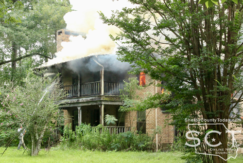
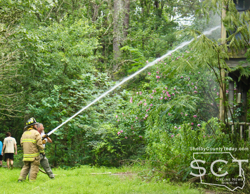
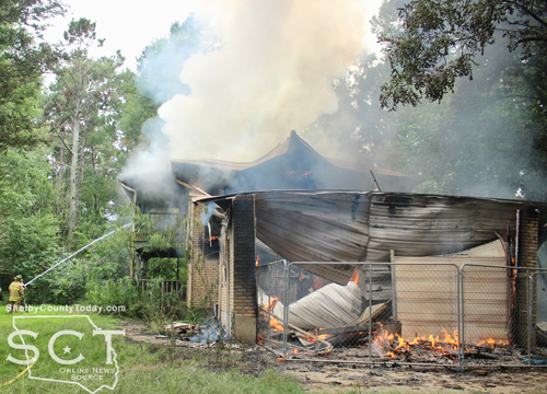
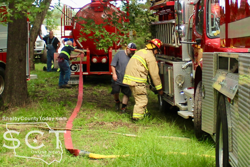
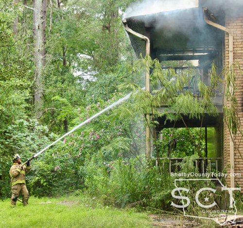
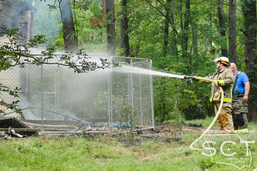
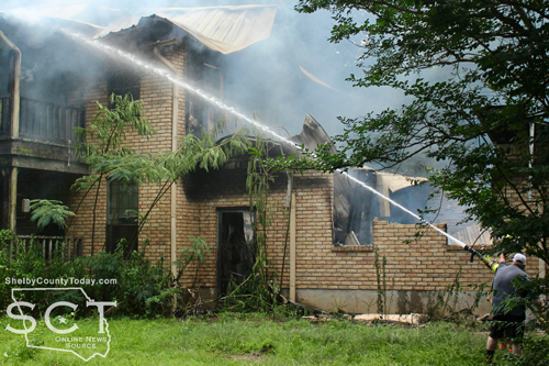
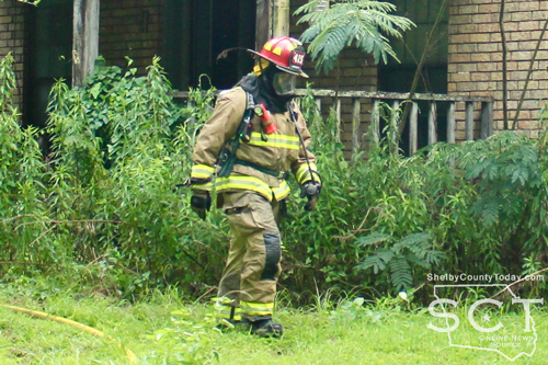
May 28, 2026 - The 3000 block of CR 4293 was the scene of a two-story house fire on Wednesday, May 27, 2026.
When firefighters arrived, the house was partially engulfed in flames on the northern side toward the structure’s garage. Firefighters were seen entering the home wearing Self-contained Breathing Apparatus (SCBA) equipment to facility a safe breathing environment while they were inside the home.
According to the Center Fire Department, they received a call at 4:15pm from a person advising that their neighbor’s house was on fire. When firefighters arrived, they found the two-story house to be on fire. The firefighters were able to extinguish the fire with assistance by Tenaha Volunteer Fire Department personnel.
A cause was not immediately reported to have been determined and it appeared that the fire began in the garage.


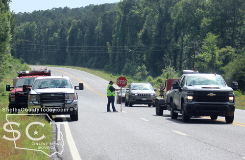
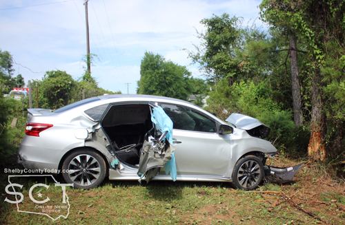
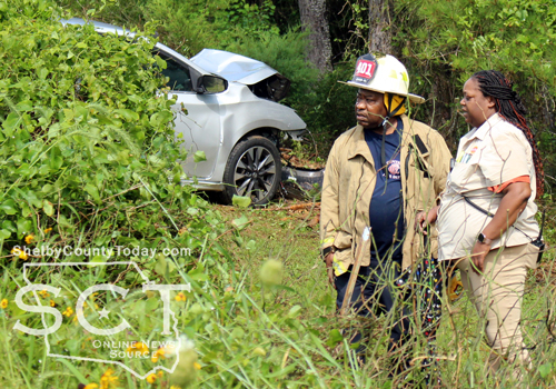
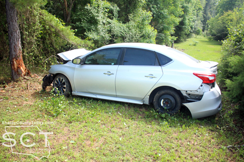
May 28, 2026 - State Highway 7 West near CR 1234 was the scene of a single-vehicle crash on Tuesday, May 26, 2026, at around 3:15pm.
Emergency personnel with multiple agencies responded to the location. Center Fire Department and West Shelby County Volunteer Fire Department both were on scene to help free the driver who was initially reported to be trapped. Extrication equipment was utilized to successfully get him out of the vehicle and assist EMS in moving him to an ambulance.
According to Texas Department of Public Safety State Trooper Matt Chandler, a silver Nissan Sentra driven by Mohamed Yakob Isack, 65, of Lufkin was eastbound at an unsafe speed on State Highway 7 when he drove off the roadway and struck a fence before then striking a tree head-on. The driver stated his windshield wipers were defective.
Isack was transported by ambulance to Shelby Emergency Department for treatment of possible injuries.
Isack was issued a citation for unsafe speed.
Shelby County Sheriff’s Deputies also assisted at the scene.

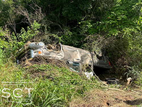
May 27, 2026 - U.S. Highway 96 North, just passed Loop 157 (Center Street) in Tenaha was the scene of a single-vehicle crash involving a pickup truck on Friday, May 22, 2026.
Tenaha Volunteer Fire Departement personnel responded to the scene to assist those involved in the crash and to initiate traffic control, if needed.
According to details from the Texas Departement of Public Safety, the preliminary crash investigation indicates that at approximately 2:14pm, a brown GMC Sierra pickup truck driven by Zaqueo Arcibar, 20, of Tenaha was traveling north. It is reported that the pickup left the road to the right and overturned.
Arcibar and two passengers Bryanna Stevens, 20, and an infant passenger, were transported to Nacogdoches Medical Center in Center for treatment of possible injuries. Arcibar was cited for fail to drive in a single lane.
According to DPS, there is no further information available.
Tenaha VFD personnel remained at the scene until the vehicle was extracted from the creek bed in which it came to rest. The truck was towed from the scene by Smith Towing.


May 26, 2026 - The May 26 Primary Runoff Elections are over and unofficial results are in.
Editor's note: Results are unofficial until they have been ratified.
Results below are in order of:
Statistics
- Ballots Cast - Total: 1,618
- Ballots Cast - Republican Party: 1,487
- Ballots Cast - Democratic Party: 131
- Ballots Cast - Blank: 1
DEMOCRAT FEDERAL AND STATE RESULTS
| UNITED STATES REPRESENTATIVE, DISTRICT 1 (DEM) |
| Dax Alexander |
| Absentee 6 | Early 12 | Election Day 26 | TOTAL 44 |
| Yolanda R. Prince |
| Absentee 24 | Early 40 | Election Day 65 | TOTAL 129 |
| LIEUTENANT GOVERNOR (DEM) |
| Marcos Isaias Velez |
| Absentee 8 | Early 9 | Election Day 14 | TOTAL 31 |
| Vikki Goodwin |
| Absentee 18 | Early 31 | Election Day 50 | TOTAL 99 |
| ATTORNEY GENERAL (DEM) |
| Joe Jaworski |
| Absentee 11 | Early 14 | Election Day 30 | TOTAL 55 |
| Nathan Johnson |
| Absentee 15 | Early 26 | Election Day 35 | TOTAL 76 |
REPUBLICAN FEDERAL AND STATE RESULTS
| UNITED STATES SENATOR (REP) |
| Ken Paxton |
| Absentee 31 | Early 484 | Election Day 571 | TOTAL 1,086 |
| John Cornyn |
| Absentee 30 | Early 150 | Election Day 216 | TOTAL 396 |
| ATTORNEY GENERAL (REP) |
| Mayes Middleton |
| Absentee 24 | Early 317 | Election Day 437 | TOTAL 778 |
| Chip Roy |
| Absentee 32 | Early 307 | Election Day 335 | TOTAL 674 |
| RAILROAD COMMISSIONER (REP) |
| Jim Wright |
| Absentee 33 | Early 263 | Election Day 374 | TOTAL 670 |
| Bo French |
| Absentee 25 | Early 356 | Election Day 384 | TOTAL 765 |
| JUDGE, COURT OF CRIMINAL APPEALS, PLACE 3 (REP) |
| Thomas Smith |
| Absentee 30 | Early 390 | Election Day 440 | TOTAL 860 |
| STATEWIDE Percentage 0% | TOTAL VOTES 0 |
| Alison Fox |
| Absentee 21 | Early 185 | Election Day 258 | TOTAL 464 |
| STATEWIDE Percentage 0% | TOTAL VOTES 0 |
May 26, 2026 - Due to a busted main line at the water distribution system, the Texas Commission on Environmental Quality has required the City of Joaquin/2100010 public water system to notify all customers to boil their water prior to consumption (e.g., washing hands/face, brushing teeth, drinking, etc.). Children, seniors, and persons with weakened immune systems are particularly vulnerable to harmful bacteria, and all customers should follow these directions).
To ensure destruction of all harmful bacteria and other microbes, water for drinking, cooking, and ice making should be boiled and cooled prior to use for drinking water or human consumption purposes. The water should be brought to a vigorous rolling boil and then boiled for two minutes.
In lieu of boiling, individuals may purchase bottled water or obtain water from some other suitable source for drinking water or human consumption purposes.
When it is no longer necessary to boil the water, the public water system officials will notify customers that the water is safe for drinking water or human consumption purposes.
Once the boil water notice is no longer in effect, the public water system will issue a notice to customers that rescinds the boil water notice in a manner similar to this notice.
Please share this information with all the other people who drink this water, especially those who may not have received this notice directly (for example, people in apartments, nursing homes, schools, and businesses). You can do this by posting this notice in a public place or distributing copies by hand or mail.
If you have questions concerning this matter, you may contact Stacy Cranford at Joaquin City Hall located at 130 Steve Hughes Dr., Joaquin, Texas 75954 at (936)269-3021.
To the registered voters of the County of Shelby, Texas:
May 18, 2026 (English/Spanish Notices: Democratic, Republican) - Notice is hereby given that the polling places listed below will be open from 7am to 7pm, May 26, 2026, for voting in the (Democratic and Republican) Primary Runoff Election.
Sample Ballots: Democratic, Republican
On Election Day, voters must vote in the precinct where registered to vote, unless the countywide polling place program is being used in the election.
Location of Election Day Polling Places Include Name of Building and Address:
- Precinct 1N (Center) - Center Community House, 423 San Augustine Street, Center, Texas 75935
- Precinct 1S (Center) - Center Community House, 423 San Augustine Street, Center, Texas 75935
- Precinct 1SE (Center) - Center Community House, 423 San Augustine Street, Center, Texas 75935
- Precinct 1SW (Center) - Center Community House, 423 San Augustine Street, Center, Texas 75935
- Precinct 1 W (Center) - Center Community House, 423 San Augustine Street, Center, Texas 75935
- Precinct 2 (Excelsior) - Excelsior ISD, 11280 St. Hwy 7 W, Center, Texas 75935
- Precinct 3 (Sardis) - First Baptist Church Fellowship Hall, 5030 St. Hwy 87 S, Shelbyville, Texas 75973
- Precinct 4 (Huxley) - First Baptist Church Fellowship Hall, 5030 St. Hwy 87 S, Shelbyville, Texas 75973
- Precinct 5 (Joaquin) - Word of Faith Outreach Center, 12413 US Hwy 84 East, Joaquin, Texas 75954
- Precinct 6 (Dreka) - First Baptist Church Fellowship Hall, 5030 St. Hwy 87 S, Shelbyville, Texas 75973
- Precinct 7 (Shelbyville) - First Baptist Church Fellowship Hall, 5030 St. Hwy 87 S, Shelbyville, Texas 75973
- Precinct 8 (Tenaha) - First Methodist Church - Schiede Hall, 256 N. George Bowers Drive, Tenaha, Texas 75954
- Precinct 9N (Timpson) - BOM Bank, 830 North 1st, Timpson, Texas 75975
- Precinct 9S (Timpson) - BOM Bank, 830 North 1st, Timpson, Texas 75975
During early voting, a voter may vote at any of the locations listed below:
Location of Main Early Voting Polling Place, Center Community House, 423 San Augustine Street, Center, Texas 75935
Days and hours of operation will be:
Monday, May 18, 2026 through Friday, May 22, 2026 7am to 7pm
Application for ballot by mail shall be mailed to:
Shelby County Early Voting Clerk
Nancy Adams, 200 San Augustine Street, Box 9, Center, Texas 75935
Telephone Number: 936-598-5340
Email: nancy.adams@co.shelby.tx.us
Early Voting Clerk's Website: www.co.shelby.tx.us/page/shelby.Elections
Application for Ballot by Mail (ABBM) must be received no later than the close of business on: May 15, 2026.
Federal Post Card Applications (FPCA) must be received no later than the close of business on: May 15, 2026.
Pages