Updated at 4:40pm: At 432 PM CDT, Doppler radar was tracking a strong thunderstorm near Joaquin, or 12 miles north of Center, moving northeast at 15 mph.
Updated at 4:25pm: The National Weather Service issued a Special Weather Statement at 4:04pm on Saturday, August 20, 2022. A strong thunderstorms will impact portions of southwestern De Soto Parish, southeastern Panola, Shelby and northeastern San Augustine Counties through 4:30pm CDT.
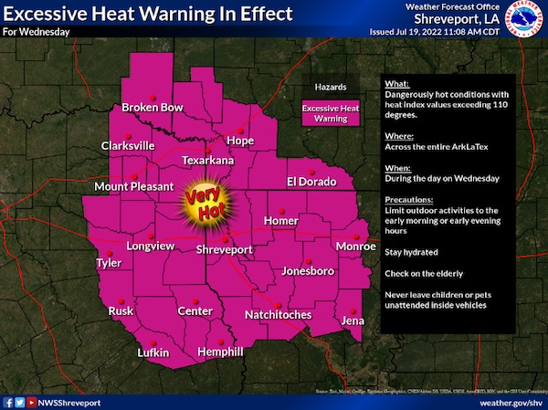
July 20, 2022 - The National Weather Service, Shreveport, LA issued at 3:07am on Wednesday, July 20, 2022 the Excessive Heat Warning remains in effect until 7pm this evening.
July 13, 2022 - The National Weather Service in Shreveport has issued a Severe Thunderstorm Warning for West central De Soto Parish in northwestern Louisiana, Southeastern Panola County in northeastern Texas, North central Shelby County in eastern Texas until 8pm CDT.
At 709 PM CDT, a severe thunderstorm was located near Joaquin, or 12 miles north of Center, and is nearly stationary.
April 13, 2022 - The National Weather Service in Shreveport LA has issued a Flood Warning for the Attoyac Bayou Near Chireno affecting Nacogdoches, Shelby, San Augustine and Rusk Counties.
For the Attoyac Bayou...including Chireno...Minor flooding is forecast.
April 13, 2022 - The National Weather Service Prediction Center, Norman, OK issued a Tornado Watch at 10:35am on Wednesday, April 13, 2022. The Tornado Watch is until 5pm.
Texas counties included are Angelina, Bowie, Camp, Cass, Cherokee, Gregg, Harrison, Marion, Morris, Nacogdoches, Panola, Rusk, Sabine, San Augustine, Shelby, Smith, Titus, and Upshur.
April 12, 2022 - The National Weather Service in Shreveport issued a Flash Flood Warning for East Central Shelby County in eastern Texas until 2:45am CDT.