July 13, 2022 - The National Weather Service in Shreveport has issued a Severe Thunderstorm Warning for West central De Soto Parish in northwestern Louisiana, Southeastern Panola County in northeastern Texas, North central Shelby County in eastern Texas until 8pm CDT.
At 709 PM CDT, a severe thunderstorm was located near Joaquin, or 12 miles north of Center, and is nearly stationary.
April 13, 2022 - The National Weather Service in Shreveport LA has issued a Flood Warning for the Attoyac Bayou Near Chireno affecting Nacogdoches, Shelby, San Augustine and Rusk Counties.
For the Attoyac Bayou...including Chireno...Minor flooding is forecast.
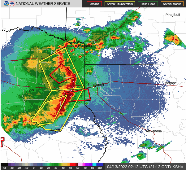
April 13, 2022 - The National Weather Service Prediction Center, Norman, OK issued a Tornado Watch at 10:35am on Wednesday, April 13, 2022. The Tornado Watch is until 5pm.
Texas counties included are Angelina, Bowie, Camp, Cass, Cherokee, Gregg, Harrison, Marion, Morris, Nacogdoches, Panola, Rusk, Sabine, San Augustine, Shelby, Smith, Titus, and Upshur.
April 12, 2022 - The National Weather Service in Shreveport issued a Flash Flood Warning for East Central Shelby County in eastern Texas until 2:45am CDT.
April 12, 2022 - The National Weather Service has issued Tornado Watch 116 in effect until 2am CDT Wednesday for the following areas in Arkansas this watch includes seven counties in South Central Arkansas, Union in Southwest Arkansas, Columbia, Hempstead, Lafayette, Little River, Miller, Nevada.
In Louisiana this watch includes 15 Parishes in North Central Louisiana, Caldwell, Jackson, Lincoln, Ouachita, Union, Winn. In Northwest Louisiana, Bienville, Bossier, Caddo, Claiborne, De Soto, Natchitoches, Red River, Sabine, Webster.